1597 Wytlfiet Map of Chile
Chile-wytfliet-1597$1,200.00

Title
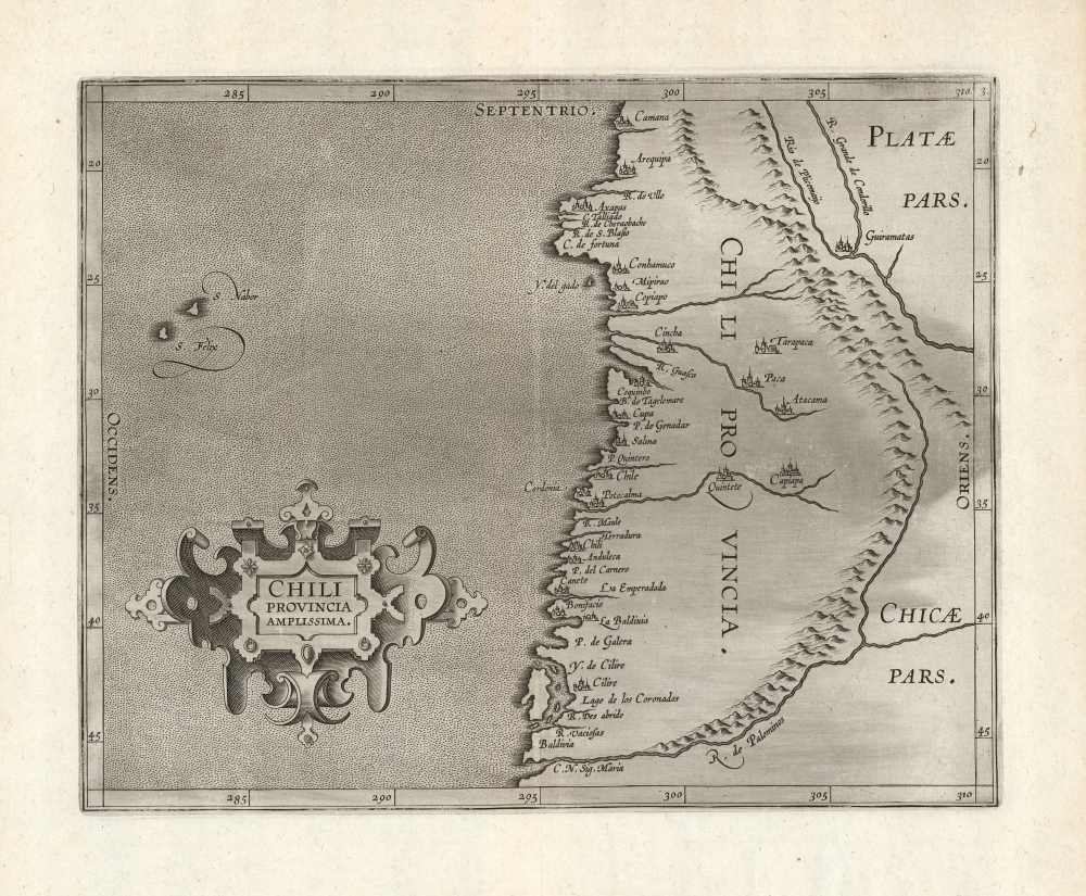
Chili Provincia Amplissima.
1597 (undated) 9 x 11.25 in (22.86 x 28.575 cm) 1 : 15500000
1597 (undated) 9 x 11.25 in (22.86 x 28.575 cm) 1 : 15500000
Description
A strong example, with an unusually bold impression, of Cornelis Wytfliet's Chili Provincia Amplissima, the first printed map to focus on Chile. It appeared in his Descriptionis Ptolemaicae Augmentum, the first atlas specifically of the Americas.
A Closer Look
The map is oriented to the north, covering from Camana to just south of Valdivia. The coastal plains are greatly exaggerated, with the mountains of the coastal range appearing far east of the coastline. The placenames and the topography - notably the bulge appearing south of Arequipa - reveal Wytfliet's source as Peter Plancius' 1592 Nova et Exacta Terrarum Orbis Tabula Geographica Ac Hydrographica, which indeed informed most of the maps of Wytfliet's atlas.Publication History and Census
The map was engraved in Louvain for inclusion in Cornelis Wytfliet's Descriptionis Ptolemaicae Augmentum, and appeared in all editions of that work. The separate map is catalogued in ten institutional collections, although it does appear on the market from time to time.CartographerS
Cornelius van Wytfliet (1555 - 1597) was a Flemish cartographer and engraver active in the second half of the 16th century. Little unfortunately is known of Wytfliet's life or education. He seems to have been employed as secretary to the Council of Brabant, essentially the supreme court of the Duchy of Brabant. In cartographic circles Wytfliet is best known for his publication in 1597 of Descriptionis Ptolemaicae Augmentum, the first atlas dedicated exclusively to the America's. Wytfliet imaged the atlas as a supplement to classical Ptolemaic geographic, which traditionally accounted only for Europe, Africa, and Asia. The 19 maps contained within the Descriptionis Ptolemaicae Augmentum are some of the earliest specific maps detailed various parts of the Americas. More by this mapmaker...
Petrus Plancius (1522 - May 15, 1622) was a Dutch-Flemish cartographer, astronomer, and clergyman. Born in Dranouter, he studied theology in Germany and England. He became a minister in the Dutch Reformed Church at the age of 24. In 1585, fearing religious prosecution by the Inquisition after Brussels fell into Spanish hands, Plancius fled to Amsterdam. It was in Amsterdam that he became interested in navigation and cartography and soon became a recognized expert on the shipping routes to India. Plancius published his best known world map in 1592, entitled ‘Nova et exacta Terrarum Tabula geographic et hydrographica’. Plancius was also one of the founders of the Dutch East India Company, for which he drew over 100 maps. Learn More...
Source
Wytfliet, C., Descriptionis Ptolemaicae Augmentum, (Louvain: Bogardus) 1597.
Wytfliet's Descriptionis Ptolemaicae Augmentum, published in Louvain (Belgium) in 1597, is considered the first atlas specifically dedicated to the Americas. Classical geography, as defined by Claudius Ptolemy's Geographia, only accounted for a three part world - consisting of Asia, Europe, and Africa. The discovery of the Americas in 1492 threw a wrench into this well-established geographic system. Wytfliet imagined his work as a supplement to the Ptolemaic atlas. Drawn from earlier maps, as well as the texts of Acosta, Hakluyt, de Bry, and Ramusio, the Descriptionis Ptolemaicae Augmentum consisted of a history of New Work exploration illustrated by 19 unique maps of the American continent. Many of the individual maps are the first specific illustrations of their respective regions. The work proved popular and went through several editions. The first Latin edition, printed in Louvain, appeared in 1597. Two subsequent Latin ediitons were printed in 1598 and 1603. Further editions appeared in 1605, 1607, and 1611.
Condition
Excellent.
References
OCLC 641545734. Rumsey 11622.017.