This item has been sold, but you can get on the Waitlist to be notified if another example becomes available, or purchase a digital scan.
1796 Carey and Tanner Map of China
China-carey-1796$225.00

Title
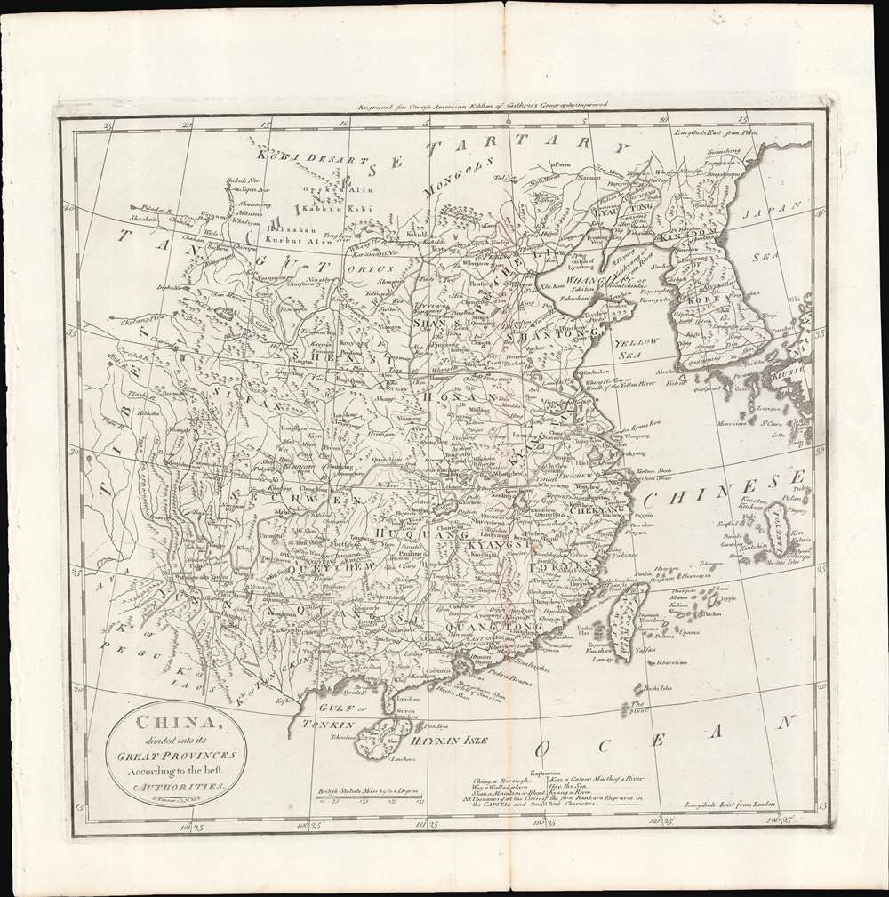
China, divided into its Great Provinces. According to the best Authorities.
1796 (undated) 16.25 x 16 in (41.275 x 40.64 cm) 1 : 15625000
1796 (undated) 16.25 x 16 in (41.275 x 40.64 cm) 1 : 15625000
Description
This is a c. 1796 map of China from Carey's General Atlas, the first atlas published in the new American Republic. It depicts 'China proper,' roughly the territory covered by the Ming Dynasty, which had been conquered by the Manchu Qing Dynasty in 1644.
The map contains several errors typical of 18th and early 19th century Western maps of China. For instance, Sifan (西番), towards left-center, was not a province or domain but a vague and inconsistently used term for people and lands to the west of the Han heartland. Translated literally, it means something close to 'Western barbarians,' or in this context, 'land of the Western barbarians.'
The Ryukyu Islands (here 'Lekeyo') and surrounding islands are far too large, reflecting their outsize importance as middlemen in trade between Japan and China, both of which had restrictive trade policies. Taiwan itself is a bit too large, most likely as Europeans were more familiar with it, with the Dutch and the Spanish having established coastal colonies there in the 17th century.
For a time, this system worked well, as China received what it needed from the outside world, namely silver to satisfy its growing and increasingly commercialized domestic economy, and foreign traders received Chinese goods (tea, silk, porcelain, lacquerware, etc.) that they could sell or exchange back in their home countries, or sometimes in India and Africa, at a considerable profit. But the insatiable demand for Chinese goods in the West without a similar demand in China for Western goods caused countries to run a large trade deficit with China, and the requirement of paying in silver was impacting the money supply of Britain and other countries.
Already by the time of this map's publication, British traders were illegally importing opium to China to offset this trade imbalance. American traders followed suit, importing opium from the Ottoman Empire, where they had a monopoly from 1805. Traders from New England were especially engaged in the 'China trade' and it supplied the fortunes of many 'Boston brahmin' families, including the Delano, whose patriarch Warren Delano Jr. (grandfather of Franklin Delano Roosevelt) was the leading partner of Russell and Co., the largest American importer of opium to China.
China - More or Less
Although this map dates to c. 1796, it presents China at an earlier date, either in the late Ming or the early Qing , before the dissolution of Huguang and Jiangnan Provinces (here Huquang and Kyangnan). This is because Carey, via Guthrie, was working from one of a small number of reliable maps of China available in 18th century Europe, most likely Jean-Baptiste Bourguignon d'Anville's c. 1730 map considered the 'gold standard' into the 19th century. As a result, the map does not include territorial additions that the Qing made, nearly doubling the size of the Ming domain by controlling (loosely) peoples and lands in Mongolia, Tibet, and Central Asia.The map contains several errors typical of 18th and early 19th century Western maps of China. For instance, Sifan (西番), towards left-center, was not a province or domain but a vague and inconsistently used term for people and lands to the west of the Han heartland. Translated literally, it means something close to 'Western barbarians,' or in this context, 'land of the Western barbarians.'
The Ryukyu Islands (here 'Lekeyo') and surrounding islands are far too large, reflecting their outsize importance as middlemen in trade between Japan and China, both of which had restrictive trade policies. Taiwan itself is a bit too large, most likely as Europeans were more familiar with it, with the Dutch and the Spanish having established coastal colonies there in the 17th century.
The 'China Trade' in the Early Republic
The southern coast of China and particularly the Pearl River Delta near Canton (Guangzhou) would have been of particular interest to Carey's audience, which was published just as Americans were becoming more involved in the trading system at Canton. This was the only way for Western traders to access the Chinese market, albeit only through designated Chinese traders called hongs (行), later merged into a monopoly called the cohong (公行), who were overseen by Qing officials.For a time, this system worked well, as China received what it needed from the outside world, namely silver to satisfy its growing and increasingly commercialized domestic economy, and foreign traders received Chinese goods (tea, silk, porcelain, lacquerware, etc.) that they could sell or exchange back in their home countries, or sometimes in India and Africa, at a considerable profit. But the insatiable demand for Chinese goods in the West without a similar demand in China for Western goods caused countries to run a large trade deficit with China, and the requirement of paying in silver was impacting the money supply of Britain and other countries.
Already by the time of this map's publication, British traders were illegally importing opium to China to offset this trade imbalance. American traders followed suit, importing opium from the Ottoman Empire, where they had a monopoly from 1805. Traders from New England were especially engaged in the 'China trade' and it supplied the fortunes of many 'Boston brahmin' families, including the Delano, whose patriarch Warren Delano Jr. (grandfather of Franklin Delano Roosevelt) was the leading partner of Russell and Co., the largest American importer of opium to China.
Publication History and Census
This map is likely from an early edition of Carey's General Atlas (sometimes subtitled American Edition of Guthrie's Geography improved), multiple editions of which were printed between 1795 and 1818. This is likely an early edition as later editions included colored ink to show borders between countries or to shade entire countries to more easily distinguish them. It appears to be identical to the edition included in the David Rumsey Map Collection, which is dated to 1796. The prevalence of the map is difficult to determine since the map is not always cataloged with the year recorded, but aside from the edition in the Rumsey Collection, it is cataloged by the Newberry Library, and the 1796 edition of the entire atlas is held by a handful of universities and research institutions in the United States.CartographerS
Matthew Carey (January 28, 1760 - September 16, 1839) was a Dublin born publisher who established himself in Philadelphia in the late 18th and early 19th century. A young man of socially progressive views, Carey's first known publication, produced when he was but 17 years old, was a pamphlet criticizing dueling. Another pamphlet, issued in the same year, attacked the Irish penal code. Shortly afterwards, in 1779, legal issues, possibly arising from his liberal political activism, forced Carey to flee to Paris. In Paris, Carey had the good fortune to befriend the visiting American diplomat and founding father, Benjamin Franklin (1706 - 1790). As an Irishman chafing under the rule of England, Carey sympathized with and admired the American revolutionary. The liberally minded pair struck up a lifelong friendship and Carey was hired to work at Franklin's press in Passy, France. A year later, Carey returned to Ireland and resumed his politically provocative publishing career with The Freemans's Journal and The Volunteer's Journal. It didn't take long for political pressure to once again force Carey from Ireland - this time to America (1784). Although largely without funds, Carey convinced Gilbert du Motier, Marquis de Lafayette (1757 - 1834), who he knew from Franklin's Paris circle, to lend him funds to establish a new publishing concern in Philadelphia. Despite this loan, Carey's firm remained under financed and opened on a shoestring budget. It was most likely his limited budget that led Carey to some of his most important publishing innovations. At the time cartographic publishing was dominated by large printing houses in London and Paris where most, if not all, of the work was completed in house. Without the finances to emulate this large publishing houses, Carey was forced to outsource much of his publishing work. This set the stage for subsequent American publishers who, in order to compete effectively with European firms, relied on an often bewildering network of alliances and collaborations. Carey was also a master of republishing many of his own maps in multiple different atlases and formats to maximize their profitability. His most important work is without a doubt the 1795 issue of the American Atlas the first atlas to be published in America. Carey died in 1839 but was succeeded by his son Henry Charles Carey (1793 - 1879) who, in partnership with his brother-in-law Isaac Lea (1792 - 1886), published numerous important maps and atlases under the Carey and Lea, Lea Brothers, and Lea and Blanchard imprints. More by this mapmaker...
Benjamin Tanner (March 27, 1775 - c. 1846) was an American engraver active in the late 18th and early 19th centuries. Benjamin was the brother of the more prominent younger brother, the Philadelphia engraver Henry S. Tanner. Benjamin, who was based in New York City for most of his early career. Although is master is unknown, he most likely trained under the New York mapmaker Peter R. Maverick. His earliest work dates to 1792 and his is known to have engraved many of the maps for Reid's 1775 An American Atlas. Around 1811 he relocated to Philadelphia and established a business with his brother as a general engraver and map publisher. He also worked as a bank note publisher under the imprint of Tanner, Vallance, Kearny & Co. perfecting the stereographic technique until roughly 1846. Learn More...
William Guthrie (1708 - March 9, 1770) was a Scottish historian, journalist, and writer. Born in Brechin, he studied at Aberdeen University with the idea of becoming a parochial schoolmaster. Instead, in 1730, he elected to settle in London and try his hand at literature. He covered parliamentary debates f or the Gentleman's Magazine and soon earned a reputation for being a political writer. He published several scholarly works, including a History of England from the Invasion of Julius Caesar to 1688 in four volumes, and, most notably, his Geographical Historical, and Commercial Grammar. Learn More...
Source
Carey, M., Carey's General Atlas, (Philadelphia: Carey) 1796.
Condition
Very good. Wear along fold line and edges, especially at top margin. Minimal periodic foxing.
References
Rumsey P683-20. OCLC 984128954.