
This item below is out of stock, but another example (left) is available. To view the available item, click "Details."
Details
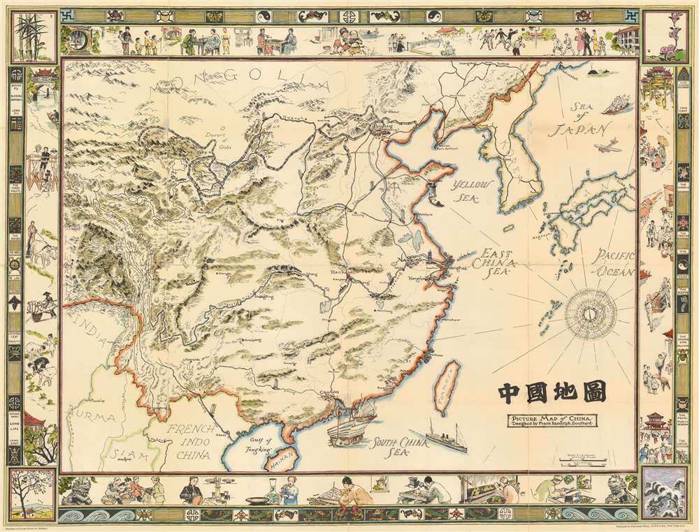
1932 Frank Randolph Southard Pictorial Wall Map of China
$1,800.00
1932 Frank Randolph Southard Pictorial Wall Map of China
China2-southard-1932$1,150.00

Title
Picture Map of China. 中國地圖
1932 (dated) 37.6 x 48.5 in (95.504 x 123.19 cm) 1 : 16000000
1932 (dated) 37.6 x 48.5 in (95.504 x 123.19 cm) 1 : 16000000
Description
This is a striking large format 1932 pictorial wall map of China illustrated by Frank Randolph Southard in 1932. The map covers all of China as well as neighboring Korea and parts of Japan. It is surrounded by an elaborate decorative border featuring Chinese iconography as well as views of Chinese street and country life. The map embraces the romanticized view of Chinese life and culture that many Americans held before World War II. It is moreover, the only large format American pictorial map of China to be issued before the war. While the present map is uncolored, Southard intended the map to be colorized by the buyer.
Publication History and Census
This map was printed and published by Gilbert Q. LeSourd of Friendship Press. Friendship Press published a number of maps and other ephemera intended to education American children about China. Among their works is this and another smaller pictorial map of China. Today it is quite rare on the market. The OCLC identifies only 3 institutional holdings. We are further aware of 2 others in private hands.CartographerS
Frank Randolph Southard (1886 - 1958) was an American painter, graphic artist, book illustrator, and photographer based in Brooklyn, New York. Southard was born in New Jersey, the son of Charles F. Southard and Katharine Emilie Keller. Southard graduated with a degree in graphic design from Pratt and studied at the Art League of Manhattan. Southard lived most of his life in Brooklyn at 1388 Dean Street. He was an avid touring cyclist and traveled extensively in Europe just prior to World War I. After returning to Brooklyn, he became licensed as a teacher of commercial design. When war broke out he joined the Army where he was assigned to the 77th Division. After the war he returned to New York where he continued to peruse his teaching and artistic career. Southard is known for numerous graphic illustrations including maps of Brooklyn and a notable pictorial wall map of China. He was married to Ida Hinsch and was survived by two children. More by this mapmaker...
Gilbert Quinn LeSourd (February 1, 1887 - June 22, 1962) was an American missionary, educator, reverend, and publisher active in New York and New Jersey in the early 20th century. LeSourd was born in Seattle, Washington. He received his early education at the College of Puget Sound, followed by and a bachelor of divinity from Drew Theological Seminary, an da doctorate of philosophy from New York University. LeSourd was the owner of Friendship Press, a printing house focused on missionary texts, maps, and other educational materials. He was also the Associate Secretary of the Missionary Education Movement. LeSourd died in Schenectady, New York. Learn More...
Condition
Good. Original creases exhibit soiling and some wear. Backed on archival tissue for stability.
References
Rumsey 11377.001. OCLC 21920663.