This item has been sold, but you can get on the Waitlist to be notified if another example becomes available, or purchase a digital scan.
1535 Fries Map of China and Japan - Rare issue of 1st European Map of East Asia
ChinaJapan-fries-1535$1,550.00

Title
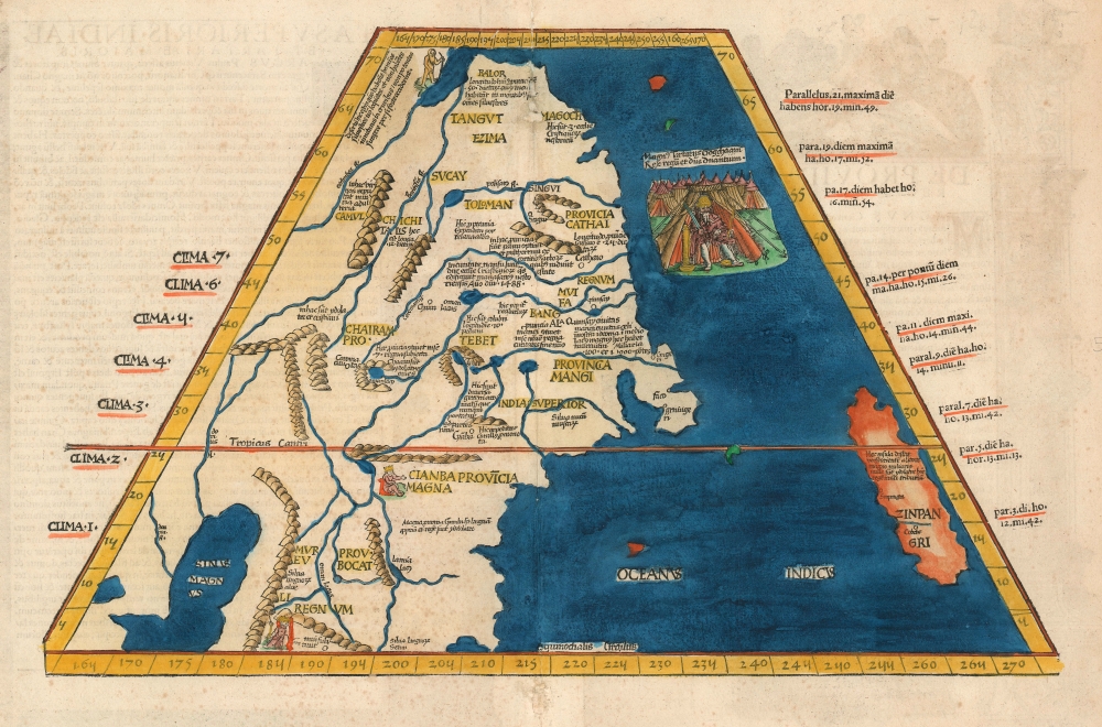
Tabula Superioris Indiae et Tartariae Majoris.
1535 (undated) 14 x 20 in (35.56 x 50.8 cm)
1535 (undated) 14 x 20 in (35.56 x 50.8 cm)
Description
A seminal work, this 1522 Lorenz Fries map is the first European map to focus on China and Japan and the first specific map to utilize Marco Polo's geographical reports of East Asia. It was also one of the first maps in a printed edition of Ptolemy's Geographia to reflect a contemporaneous understanding of the region depicted. It is, moreover, the only acquirable printed map of the region derived from Martin Waldseemüller's great 1507 world map. Surprisingly, Waldseemüller's depiction of Japan was not reprised in the 1513 Ptolemy, either on the world map or on any more narrowly focused map. It represents one of the first efforts to reconcile ancient geography with the growing stream of new information coming back from recent exploration and geographical theory.
Framework
The map utilizes a Ptolemaic, trapezoidal projection. It retains some of Ptolemy's assumptions - most notably the existence of the Sinus Magnus ('Great Bay') beyond the Malay Peninsula and the coast of Vietnam, and a vast land mass reaching south, beyond, and below that bay. The map then incorporates new information - derived from the 1507 Waldseemüller - where this new cartographic information about East Asia appeared for the first time on a map.The New Data
The map features an abundance of place names that were utterly unknown to Ptolemy. Northern China, Provincia Cathai, is named; south of that, Marco Polo's Provincia Mangi appears. Far to the north, the 'Balor' are identified with an accompanying photograph of a bearded hunter - these were nomadic people who, according to Marco Polo, ate 'only deer.' Off the coast to the right of Cathai is an impressive illustration of the Great Khan, King of the Tartars, sitting in a tent surrounded by his army. It was the Great Khan's court that received Marco Polo along with his father and uncle during their journey. Tibet, here spelled 'Tebet,' is prominent - of note, this is the earliest acquirable map to use that place name. The Champa civilization, which prospered in modern-day Vietnam, is here identified as Cianba Provincia Magna, with the king of Champa illustrated on his throne. (Fries' retention of the so-called 'Dragon's Tail' (see below) confuses matters: 'Cianba' ought to be further west.) Likewise, Bocat - that is to say, Cambodia (Cambocati) - appears here on the eastern rather than the western shore of the Sinus Magnus. Were it not for the efforts to preserve Ptolemy's geography, these places would have likely been much more accurately positioned; as it is, the retention of the Sinus Magnus led Waldseemüller and Fries to place these kingdoms too far to the east.Japan
In the Pacific to the east of China, a large island is shown and identified as Zinpangri, which is Japan. This is the first regional map to show Japan in relation to the coast, and to show it based on the data appearing on the 1507 Waldseemuller: the two cities there, Sinpaugen and Cobebe appear first on the Waldseemüller. The only earlier separate map of Japan, appearing in the 1528 Bordone, does not place the island in relation to the coast and does not include any placenames beyond a single city of 'Ciampagu.'Indian Ocean, the Sinus Magnus, and Ptolemy's Appendix
Waldseemüller's geography in many areas radically moved beyond Ptolemaic assumptions, but in other areas made more gradual shifts. One of the notable features of early world maps based on Ptolemy is that the Indian Ocean was mapped as an inland sea, with the southern part of Africa continuing eastward to meet, beyond the Malay peninsula, with China. The body of water between the Malay Peninsula and this encircling landmass Ptolemy termed the Sinus Magnus (the Great Bay.) By the time Waldseemüller was producing his map, Europeans well understood that such a 'land bridge' between Africa and China did not exist (Portuguese navigation had proven this point), but there was as yet no exploratory evidence to indicate what precisely was beyond the legendary Sinus Magnus.. The solution offered by Henry Martellus in 1490 (which Waldseemüller adopted) was to truncate the 'land bridge' at a point some distance south of India-beyond-the-Ganges. What remained, then, of the land mass once thought to enclose the Indian Ocean was a massive, inward-curving peninsula referred to as the Dragon's Tail. This feature graces many late 15th and early 16th-century world maps, including Waldseemüller's 1507 and 1513 maps. Fries, whose work was essentially a new edition of Waldseemüller, incorporates the same feature on both of his 'modern' world maps and includes the northernmost portions of it on his map of China and Japan.Publication History and Census
This map was first issued in the 1522 Lorenz Fries Strasbourg edition of Ptolemy's Geographia. Another edition was produced in that same city in 1525. Thereafter, two further editions of 1535 and 1541 were published in Lyons and Vienne-in-the-Dauphane, respectively. The editor of the 1535 edition, Michael Villanovus (better known as Servetus), was tried for heresy in 1553 and burned at the stake. Reportedly, Calvin ordered copies of the Servetus edition of the book to be burned. Consequently, maps from the 1535 edition (of which this is a representative) are scarce. The four editions of Fries' Ptolemy are, overall, well-represented in institutional collections.CartographerS
Lorenz Fries (c. 1490 – 1531) was a German cartographer, cosmographer, astrologer, and physician based in Strasbourg. Little is known of Fries' early life. He may have studied in Padua, Piacenza, Montpellier, and Vienna, but strong evidence of this is unfortunately lacking. The first recorded mention of Fries on a 1513 Nuremberg broadside. Fries settled in Strasbourg in March of 1519, where he developed a relationship with the St. Die scholars, including, among others, Walter Lud, Martin Ringmann, and Martin Waldseemüller. There, he also befriended the printer and publisher Johann Grüninger. Although his primary profession was as a doctor, from roughly 1520 to 1525, he worked closely with Grüninger as the geographic editor of various maps and atlases based upon the work of Martin Waldseemüller. Although his role is unclear, his first map seems to have been a 1520 reissue of Waldseemüller's world map of 1507. Around this time, Fries also began working on Grüninger's reissue of Waldseemüller's 1513 edition of Ptolemy's Geographie Opus Novissima. That edition included three new maps by Fries based upon the Waldseemüller world map of 1507 – two of these, his maps of East Asia and Southeast Asia, are quite significant as the first specific maps of these regions issued by a European publisher. In 1525, Fries decided to leave Strasbourg and surrendered his citizenship, relocating to Trier. In 1528, he moved to Basel. Afterward, he relocated to Metz where he most likely died. In addition to his cartographic work, Fries published tracts on medicine, religion, and astrology. More by this mapmaker...
Martin Waldseemüller (September 11, 1470 - March 16, 1520) was a German cartographer, astronomer, and mathematician credited with creating, along with Matthias Ringmann, the first map to use the placename America. He was born in Wolfenweiler, near Freiburg im Breisgau. Waldseemüller studied at the University of Freiburg and, on April 25, 1507, became a member of the Gymnasium Vosagese at Saint-Dié. Martin Waldseemüller was a major proponent of theoretical or additive cartography. Unlike contemporary Portuguese and Spanish cartographers, who left maps blank where knowledge was lacking, Waldseemüller and his peers speculated based upon geographical theories to fill unknown parts of the map. He is best known for his Universalis Cosmographia a massive 12-part wall map of the world considered the first map to contain the name America, today dubbed as 'America's Birth Certificate'. This map also had significance on other levels, as it combined two previously unassociated geographical styles: Ptolemaic Cartography, based on an ancient Greek model, and the emergent 'carta marina', a type of map commonly used by European mariners in the late 15th and 16th centuries. It also extended the traditional Ptolemaic model westward to include the newly discovered continent of America, which Waldseemüller named after the person he considered most influential in its discovery, Amerigo Vespucci. When Waldseemüller died in 1520, he was a canon of the collegiate Church of Saint-Dié. In contemporary references his name is often Latinized as Martinus Ilacomylus, Ilacomilus, or Hylacomylus. Learn More...
Source
Ptolemy, C., Geographicae Enarrationis..., (Lyons: Servetus) 1535.
Condition
Good. Minor centerfold repair, top center. Attractive hand color. Even overall toning. Latin text on verso.
References
A. E. Nordenskold, A. E., The Early History of Cartography, p. 101.63. Saurez, T., Early Mapping of Southeast Asia, pp 114 - 119.