This item has been sold, but you can get on the Waitlist to be notified if another example becomes available, or purchase a digital scan.
1848 Horsburgh Map of of the South China Sea: Hong Kong, Philippines, Hainan
ChinaSeaHongKong-horsburgh-1848$1,475.00

Title
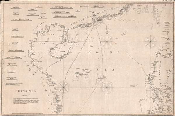
China Sea. Sheet II.
1848 (dated) 26.5 x 39.5 in (67.31 x 100.33 cm) 1 : 2200000
1848 (dated) 26.5 x 39.5 in (67.31 x 100.33 cm) 1 : 2200000
Description
An attractive example of James Horsburgh's rare 1848 China Trade nautical chart or Maritime map of the South China Sea, including Hong Kong, Macao, Canton (Guangzhou), the Philippines, Hainan, the Paracel Islands, southern Taiwan (Formosa), and the northeastern coast of modern day Vietnam. This edition of the chart includes Hong Kong and Victoria, founded as a British Crown Colony after the First Opium War only a few years prior. Four routes from Hong Kong are identified, one for the early part of the 'Northeast Monsoon,' one for the 'Late Season,' one passing by the Philippines, and a third coast hugging route for 'leaky or crazy ships.' There are 23 coastal profiles occupying the left-hand quadrants of the map.
This chart expands somewhat on Horsburgh's earlier 1811 chart of the same region, offering a more accurate charting of the China coast, adding shipping route details important to the Hong Kong trade, and incorporating Luzon in the Philippines. Much of the cartography is the work of Daniel Ross, considered the Father of the Indian Surveys, who surveyed the coast of south China between 1806 and 1820. It was first published in 1823, and here exhibits updates and revisions to 1848.
This chart expands somewhat on Horsburgh's earlier 1811 chart of the same region, offering a more accurate charting of the China coast, adding shipping route details important to the Hong Kong trade, and incorporating Luzon in the Philippines. Much of the cartography is the work of Daniel Ross, considered the Father of the Indian Surveys, who surveyed the coast of south China between 1806 and 1820. It was first published in 1823, and here exhibits updates and revisions to 1848.
CartographerS
James Horsburgh (September 28, 1762 – May 14, 1836) was a Scottish hydrographer and navigator active in the late 18th and early 19th century. Horsburgh was born in Fife, Elie, Scotland, to a humble family. Like many young Scottish men of little means, Horsburgh was destined for a sea-faring life and at just 16 signed on as a cabin boy in a coal trading ship. After many misadventures, including a brief incarceration by the French at Dunkirk, Horsburgh made his way to the West Indies and eventually to Calcutta, India. As the center for British maritime trade in the region, Horsburgh had no difficulty finding work with the British East India Company who maintained an active trade network between India and China. Despite the regular trade, one these voyages to China, aboard the ironically named Atlas, taught Horsburgh just how poorly the East Indies were charted. The 1786 shipwreck of the Atlas, on which he was the First Mate, near Diego Garcia Island proved a pivotal moment Horsburgh's life. He subsequently devoted himself to accurately charting the Indian Ocean and the dangerous Straits of Malacca, Sunda, and Singapore. Many of Horsburgh's charts are the direct results of his own unique survey work on board the Carron and later as captain of the Anna. Horsburgh's work culminated in the publication if his 1809 Directions for Sailing to and from the East Indies, China, New Holland, Cape of Good Hope, and the Interjacent Ports, a monumentally important guide to navigating the waters of the Indian Ocean and the East Indies. His work earned him friendships in London's highest naval and scientific circles, among them Joseph Banks and Alexander Dalrymple. He became a member of the Royal Society in 1806, when he retired from active sailing. When Alexander Dalrymple died in 1810, Horsburgh was appointed to the prestigious position of Hydrographer to the British East India Company where he worked until his death in 1836. Whereas Dalrymple was somewhat indiscriminate regarding the charts he published, Horsburgh was exacting and double checked the veracity of each and every chart that passed through his office. Horsburgh's work with the East India Company elevated the standards of the Hydrographic Department and earned him a Fellowship with the Royal Society. Today's Horsburgh's accomplishments are memorialized by the Horsburgh Lighthouse, near Singapore, and Horsburgh Island. When Horsburgh died most of his work was passed by his children to the Admiralty, which continued to publish updates until roughly 1864. More by this mapmaker...
Daniel Ross (November 11, 1780 - October 29, 1849) was a British hydrographer and naval officer active in India and the Far East during the first half of the 19th century. Ross is admiringly referred to as 'The Father of the Indian Surveys.' He was born in Jamaica, the illegitimate son of Hercules Ross (1745 - December 25, 1816), a powerful Jamaican-English merchant, privateer ship owner, and naval price agent. His mother was Elizabeth Foord, a quadroon slave who Hercules later freed. Ross joined the Bombay Marine in 1795. From 1806 to 1820 he was assigned to survey the coast of China from Vietnam to Macao. In 1822 he was elected a fellow of the Royal Society. By 1823 he had been appointed Marine Surveyor General of Calcutta, a position he held until he resigned in 1833. Afterwards he retired to Bombay (Mumbai) where in 1838 he was appointed President of the Bombay Geographical Society. He retained the position until retiring in ill-heath in 1849. He is the half-brother of sportsman and photography pioneer Horatio Ross. Learn More...
Condition
Good. Overall toning. Minor margin repair and reinforcements on verso. Lower margin narrow and chipped in a few places.
References
Library of Congress, Map Division, G7822.C5 1823 .H6.