This item has been sold, but you can get on the Waitlist to be notified if another example becomes available, or purchase a digital scan.
1925 U.S. Coast and Geodetic Survey Climate Map of the Philippines
ClimatePhilippines-uscgs-1925$87.50

Title
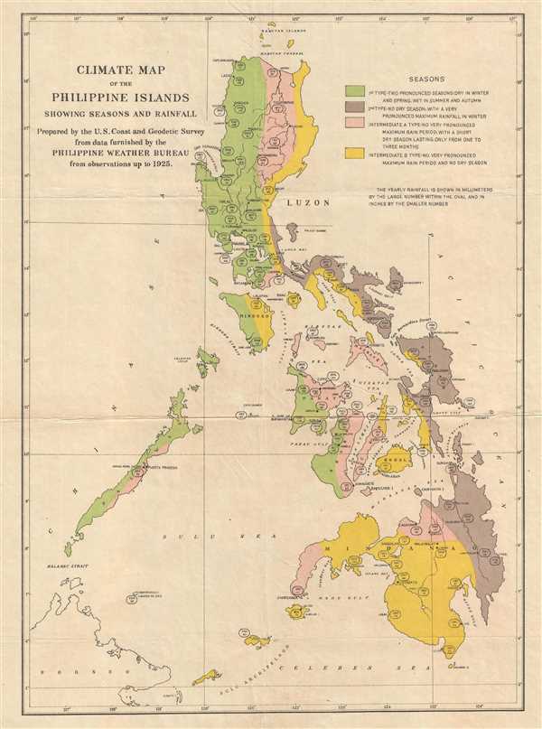
Climate Map of the Philippine Islands showing Seasons and Rainfall.
1925 (dated) 16.5 x 12 in (41.91 x 30.48 cm) 1 : 4300000
1925 (dated) 16.5 x 12 in (41.91 x 30.48 cm) 1 : 4300000
Description
This is a 1925 U.S. Coast and Geodetic Survey climate map of the Philippines. The map depicts the entire Philippine Archipelago from the Babuyan Islands and Luzon to Mindanao, the Sulu Archipelago, and the Celebes Sea; and from the China Sea to the Pacific Ocean.
Four different climate types are illustrated. The first type has two pronounced seasons: dry in the winter and in the spring and we in the summer and fall. The second type has no dry season with a very pronounced maximum rainfall during the winter. Per the map, there are two intermediate climates: intermediate A type and intermediate B type. The intermediate A type climate has no very pronounced maximum rain period with a short dry season which lasts for only one to three months, while the intermediate B period has no very pronounced maximum rain period and no dry season. Yearly rainfall totals are noted on the map in the ovals, with the larger number denoting millimeters and the smaller number denotes inches. Numerous cities are labeled, including Manila, Capiz, Iloilo, Cebu, and the Iwahig Penal Colony.
This map was prepared by the U.S. Coast and Geodetic Survey from data furnished by the Philippine Weather Bureau in 1925.
Cartographer
The Office of the Coast Survey (later the U.S. Geodetic Survey) (1807 - present), founded in 1807 by President Thomas Jefferson and Secretary of Commerce Albert Gallatin, is the oldest scientific organization in the U.S. Federal Government. Jefferson created the "Survey of the Coast," as it was then called, in response to a need for accurate navigational charts of the new nation's coasts and harbors. The first superintendent of the Coast Survey was Swiss immigrant and West Point mathematics professor Ferdinand Hassler. Under the direction of Hassler, from 1816 to 1843, the ideological and scientific foundations for the Coast Survey were established. Hassler, and the Coast Survey under him developed a reputation for uncompromising dedication to the principles of accuracy and excellence. Hassler lead the Coast Survey until his death in 1843, at which time Alexander Dallas Bache, a great-grandson of Benjamin Franklin, took the helm. Under the leadership A. D. Bache, the Coast Survey did most of its most important work. During his Superintendence, from 1843 to 1865, Bache was steadfast advocate of American science and navigation and in fact founded the American Academy of Sciences. Bache was succeeded by Benjamin Pierce who ran the Survey from 1867 to 1874. Pierce was in turn succeeded by Carlile Pollock Patterson who was Superintendent from 1874 to 1881. In 1878, under Patterson's superintendence, the U.S. Coast Survey was reorganized as the U.S. Coast and Geodetic Survey (C & GS or USGS) to accommodate topographic as well as nautical surveys. Today the Coast Survey is part of the National Oceanic and Atmospheric Administration or NOAA. More by this mapmaker...
Condition
Very good. Backed on archival tissue for stability. Blank on verso.
References
OCLC 214958743.