1846 Blunt Blueback Nautical Chart of the Atlantic Coast of the United States
CoastNorthAmerica-blunt-1846$950.00


Title
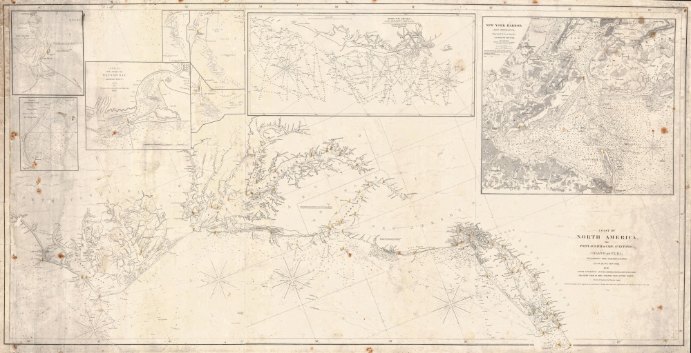
Coast of North America, from Point Judith to Cape St. Antonio (Island of Cuba) Including the Bahama Banks.
1846 (dated) 29.5 x 58 in (74.93 x 147.32 cm) 1 : 750000
1846 (dated) 29.5 x 58 in (74.93 x 147.32 cm) 1 : 750000
Description
This is a first edition 1846 Edmund and George William Blunt nautical map of the mid-east coast of the United States featuring manuscript notations.
A Closer Look
Coverage embraces from Barren Inlet, North Carolina, to Point Judith, Rhode Island. Dense depth soundings are indicated along the coast, in Long Island Sound, Delaware Bay, and Chesapeake Bay, and along the Potomac River to Washington, D.C. Cities up and down the Atlantic Seaboard are labeled, including New London, New Haven, New York City, Brooklyn, Williamsburg, Philadelphia, Wilmington, and Annapolis. Other identified locations include Cape Lookout, Cape Hatteras, Cape Henry, Cape Henlopen, Cape May, and Block Island. Lighthouses are noted by red dots with yellow beams emitting from them. Inset maps of New York Harbor, Absecum Shoals, Cape Fear, Cape Hatteras, Cape Lookout, Winyaw Bay, Bald Head, and Lewiston Bay are situated along the top border. Manuscript navigational notes appear along the coast from Ocracock Inlet, North Carolina, to Montauk Point on Long Island, complete with course information and other notes.Blueback Charts
Blueback nautical charts began appearing in London in the late 18th century. Bluebacks, as they came to be called, were privately published large-format nautical charts known for their distinctive blue paper backing. The backing, a commonly available blue manila paper traditionally used by publishers to wrap unbound pamphlets, was adopted as a practical way to reinforce the low-quality paper used by private chart publishers trying to cut costs. The earliest known blueback charts include a 1760 chart issued by Mount and Page and a 1787 chart issued by Robert Sayer. The tradition took off in the early 19th century, when British publishers like John Hamilton Moore, Robert Blachford, James Imray, William Heather, John William Norie, Charles Wilson, David Steel, R. H. Laurie, and John Hobbs, among others, rose to dominate the chart trade. Bluebacks became so popular that the convention was embraced by chartmakers outside of England, including Americans Edmund March Blunt and George Eldridge, as well as Scandinavian, French, German, Russian, and Spanish chartmakers. Blueback charts remained popular until the late 19th century when government-subsidized organizations like the British Admiralty Hydrographic Office and the United States Coast Survey began issuing their own superior charts on high-quality paper that did not require reinforcement.Publication History and Census
This chart was first published by Edmund and George William Blunt in 1846 and appeared in several subsequent editions through 1869. We have located a handful of examples of later editions of this chart dating mostly from the mid-1850s through the 1860s in institutional collections and on the private market. We have not located any examples from the 1840s, and there are no other known examples of the 1846 first edition.CartographerS
Edmund March Blunt (June 20, 1770 - 1862) was an American navigator, bookseller, chartmaker, and cartographer based in Newburyport, Massachusetts. Blunt was born in Portsmouth, New Hampshire in 1770. In 1796, along with the nominal assistance of prominent navigator Captain Lawrence Furlong, Blunt published The American Coast Pilot, one of the most important published works on American navigation. Although much of the work was plagiarized from British publications, the Coast Pilot was an immediate popular success. In response to the popularity of his work, Blunt published 21 subsequent editions, each with important updates and revisions. The first edition to contain map plates was printed in 1804. Following a fire that destroyed his offices at The Sign of the Bible in 1811, Blunt moved his business to New York and opened a new shop, The Sign of the Quadrant. His sons Edmund Jr. (1799 - 1866) and George William (1802 - 1878), joined the firm in 1824 and eventually took over the family business, renaming the firm 'E. and G. W. Blunt'. They both produced their own nautical books, charts, and instruments, as well as republished their father’s work. In 1830, Edmund accepted a position under Ferdinand Hassler at the United States Office of the Coast Survey. Much of Blunt's original work eventually found its way into U.S. Coast Survey Publications. George closed the firm in 1872 and sold the plates and chart copyrights to the U.S. Coast Survey and the U.S. Navy Hydrographic Office. Due to the quality and detail of Blunt's work, revised editions of his most important charts were republished well into the 1880s. More by this mapmaker...
Charles Copley (1800 - November 17, 1880), was an American nautical chart and globe publisher based in Brooklyn, New York and active in the middle part of the 19th century. He was born in England and emigrated to the United States in the 1840s. He became a citizen in 1844. Charles Copley's earliest work is associated with the firm of E. and G. W. Blunt and his name appears as hydrographer or engraver on several of Blunt's c. 1840 charts – so he must have began working the Blunt shortly after emigrating. Around 1847 Copley began publishing independently, advertising himself as an engraver and map publisher. Most of his independent work was published in the 1850s. By 1860, the firm renamed itself Charles Copley and Son's, accommodating Charles John Copley Jr. (1826 - 18xx) and Frederick S. Copley (1827 - 18xx). From this point forward, most charts are copyrighted by 'C.C.J and F.S. Copley.' All Copley charts are extremely rare. Learn More...
Condition
Good. Blueback. Working nautical chart. Remargined along left side. Soiling and cracking.