
This item below is out of stock, but another example (left) is available. To view the available item, click "Details."
Details
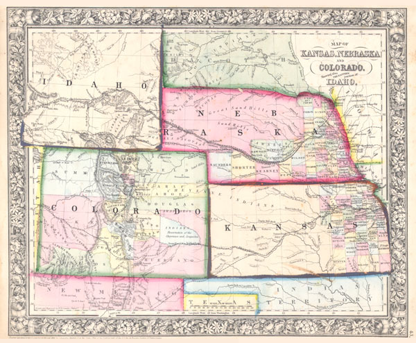
1863 Mitchell Map of Colorado, Kansas, Nebraska and Idaho / Wyoming
1863 (dated) $350.00
1864 Mitchell Map of Colorado, Kansas & Nebraska
COKANE-mitchell-1864$125.00

Title
Map of Kansas, Nebraska and Colorado, Showing also the Eastern Portion of Idaho.
1861 (dated) 11.5 x 14 in (29.21 x 35.56 cm)
1861 (dated) 11.5 x 14 in (29.21 x 35.56 cm)
Description
A beautiful example of S. A. Mitchell Jr.'s 1864 map of Kansas, Nebraska, Colorado and Idaho. Wyoming has yet to appear. Counties cover only the eastern portions of Nebraska and the eastern third of Kansas. Shows various proposed railroads, geographic features, American Indian tribes, and gold deposits as well as providing details on towns, counties, and other political data. Following the gold rush settlers teamed into the region seeking a new life and new opportunities in the American 'wild west.' Identifies both the Santa Fe Trail and the Pony Express Route. One of the most interesting and ephemeral maps of this transitional region to appear in the mid 19th century. Prepared by W. H. Gamble for inclusion as plate 43 in the 1864 issue of Mitchell's New General Atlas. Dated and copyrighted, 'Entered according to Act of Congress in the Year 1861 by S. Augustus Mitchell Jr. in the Clerk's Office of the District Court of the U.S. for the Eastern District of Pennsylvania.'
Cartographer
Samuel Augustus Mitchell (March 20, 1792 - December 20, 1868) began his map publishing career in the early 1830s. Mitchell was born in Bristol, Connecticut. He relocated to Philadelphia in 1821. Having worked as a school teacher and a geographical writer, Mitchell was frustrated with the low quality and inaccuracy of school texts of the period. His first maps were an attempt to rectify this problem. In the next 20 years Mitchell would become the most prominent American map publisher of the mid-19th century. Mitchell worked with prominent engravers J. H. Young, H. S. Tanner, and H. N. Burroughs before attaining the full copyright on his maps in 1847. In 1849 Mitchell either partnered with or sold his plates to Thomas, Cowperthwait and Company who continued to publish the Mitchell's Universal Atlas. By about 1856 most of the Mitchell plates and copyrights were acquired by Charles Desilver who continued to publish the maps, many with modified borders and color schemes, until Mitchell's son, Samuel Augustus Mitchell Junior, entered the picture. In 1859, S.A. Mitchell Jr. purchased most of the plates back from Desilver and introduced his own floral motif border. From 1860 on, he published his own editions of the New General Atlas. The younger Mitchell became as prominent as his father, publishing maps and atlases until 1887, when most of the copyrights were again sold and the Mitchell firm closed its doors for the final time. More by this mapmaker...
Source
Mitchell's New General Atlas, containing Maps of the Various Countries of the World, Plans of Cities, Etc., Embraced in Fifty-three Quarto Maps, forming a series of Eighty-Four Map and Plans, together with Valuable Statistical Tables. (1864 Edition)
Condition
Very good condition. Wide clean margins. Blank on verso. Color degradation on Idaho and Kansas border.
References
Karrow, Robert W., Checklist of Printed Maps of the Middle West to 1900, 1-0176. Rumsey 2483.036. Phillips (Atlases) 831-16. Wheat, Carl Irving, Mapping of the Transmississippi West, 1540-1861, 1030.