This item has been sold, but you can get on the Waitlist to be notified if another example becomes available, or purchase a digital scan.
1798 Wigram Map Columbia County, New York (1850 reissue)
ColumbiaCounty-wigram-1850-2$100.00

Title
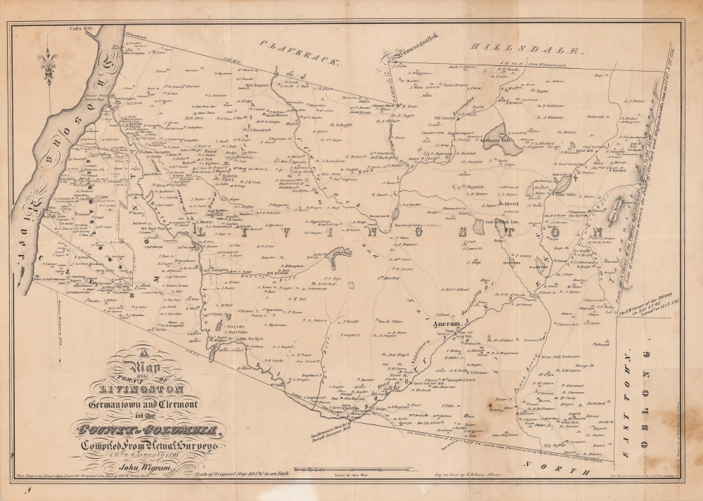
A Map of the Towns of Livingston Germantown and Clermont in the County of Columbia.
1850 (dated) 17 x 24 in (43.18 x 60.96 cm) 1 : 63360
1850 (dated) 17 x 24 in (43.18 x 60.96 cm) 1 : 63360
Description
A fine example of David Vaughan's 1850 reissue of John Wigram's 1798 ornate map of the towns of Livingston, Germantown, and Clermont in Columbia County, New York. It was produced for The Documentary History of the State of New-York, an important reference work for the early history of the state.
Aside from their eponymous manor, the Livingston family also were Lords of the Claremont Manor to the south of Germantown (not noted here, but perhaps the home marked 'Madam Livingston'). Descendants of the Livingstons include Presidents George H. W. and George W. Bush, Eleanor Roosevelt, members of the Astor family, and Robert R. Livingston, a Founding Father who signed the Declaration of Independence.
A Closer Look
The map covers the Hudson River to the boundary of Massachusetts. Multiple homesteads, family names, farms, mills, roads, churches, rivers, lakes, and various other topographical details are identified. Notably, individual landowners are recorded in significant detail. The boundaries of the towns named in the title, as well as neighboring towns, are also drawn.American Aristocrats
The Livingston Manor is identified along the Hudson River. This should not be confused with the hamlet of Livingston Manor further west in Sullivan County, named in honor of the same family. The original Livingston Manor seen here was a massive land grant along both sides of the Hudson River. Palatine German refugees worked the land in the early 18th century, mostly cutting timber for the Royal Navy, the origin of the name Germantown.Aside from their eponymous manor, the Livingston family also were Lords of the Claremont Manor to the south of Germantown (not noted here, but perhaps the home marked 'Madam Livingston'). Descendants of the Livingstons include Presidents George H. W. and George W. Bush, Eleanor Roosevelt, members of the Astor family, and Robert R. Livingston, a Founding Father who signed the Declaration of Independence.
Publication History and Census
This map was originally drawn by John Wigram in 1798. David Vaughan, a cartographer working for the State Engineer and Surveyor, accessed and copied the original in the late 1840s, and his drawing was then engraved by R. H. Pease for publication in The Documentary History of the State of New-York. Wigram's original is only held by the State Library of New York in Albany, while Vaughan's 1850 reissue is cataloged among the holdings of the New York Historical Society, the New York Public Library, the Brooklyn Public Library, the Library of Congress, the University of Wisconsin-Milwaukee, and the University of California Los Angeles, while the entire Documentary History of the State of New-York is more widely distributed in institutional collections.CartographerS
Richard H. Pease (1813 - 1869) was an American merchant and lithographer active in Albany, New York, during the middle part of the 19th century. Pease is best recognized for his publication of America's first Christmas card for the 1849 -1850 holiday season. He also played a role in populating the American version of Santa Claus and tying it to consumerism in the holiday advertisements his produced for his 'Temple of Fancy or Pease's Great Variety Store.' Pease operated the Great Variety Store in tandem with his lithography business until he passed the store on to his son, Harry E. Pease, in 1855. The store was located at 516 Broadway, Albany. Pease also published hand-colored lithographs of fruit for Ebenezer Emmons’s book Agriculture of New York State, published between 1846 and 1854. From 1856 to 1867 he worked with the lithography firm of Hoffman, Knickerbocker and Co. More by this mapmaker...
David Vaughan (? - 1865) was an Irish-born cartographer who settled in Albany, New York and worked for the State Engineer and Surveyor. He was renowned for maps that proved crucial to the enlargement of the Erie Canal and the construction of the Adirondack reservoirs in the 1850s - 1860s. His maps tended towards embellishment, with ornate lettering, depictions of animals, and illustrations of local lore. Learn More...
Source
Morgan, C., The Documentary History of the State of New-York, (Albany: Weed, Parsons, and Co.), 4 Vols, 1849 - 1851.
Condition
Good. Fold lines visible. Uneven toning and soiling, especially towards bottom-right.
References
OCLC 877912472.