This item has been sold, but you can get on the Waitlist to be notified if another example becomes available, or purchase a digital scan.
1876 Treadwell View and Map of the Comstock Mines, Nevada
ComstockMinesNevada-treadwell-1876$1,875.00

Title
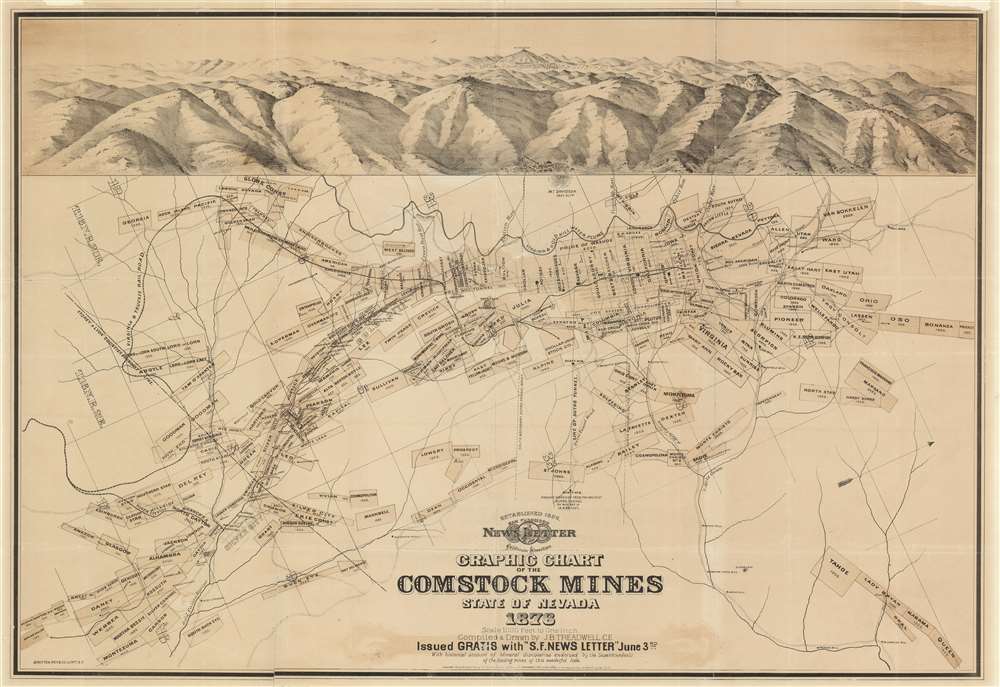
Graphic Chart of the Comstock Mines State of Nevada 1876.
1876 (dated) 25 x 36 in (63.5 x 91.44 cm) 1 : 12000
1876 (dated) 25 x 36 in (63.5 x 91.44 cm) 1 : 12000
Description
A scarce 1876 broadsheet map and view of the Comstock Mines in Nevada by the mining engineer John B. Treadwell. Treadwell at the time was manager of the Comstock Mine. Oriented to the west and roughly centered on Virginia City, the map details the heart of the Comstock Strike, what is generally known as the Mother Lode. It identifies claims in and around Virginia City, Gold Hill, and Silver City. Surmounting the map there is a view of the silver region centered on Mount Davidson and Virginia City. At the base of the view is Dayton, Nevada, and the outlet of the Sutro Tunnel.
As the most significant discover since the California Gold Rush of 1849, the Comstock discovery precipitated a major silver rush in 1859, leading to six great 'Bonanzas' and countless enormous fortunes. The discover precipitated the construction of several boom towns, including Virginia City and Silver City. Most history suggest that silver in the region began to decline in 1874, but in fact, it was in that year that the largest discovery the 'Big Bonanza' occurring right below Virginia City! The mines remained active until the 1920s.
This view is extremely rare. It is identified in the OCLC in 2 institutional collections. Six additional collections hold facsimiles. There most recent market history we have been able to identify is a dealer catalog listing in 1956.
The Comstock Lode
The Comstock Lode was the first major silver mine in the United States. Named after the fur trader and silver miner Henry Comstock (who did not himself profit from the discovery), the Comstock Lode was located under the eastern slope of Mount Davidson, in the Virginia Range of modern-day Nevada. From about 1850 the area was known for gold, which Mormon emigrants discovered in Gold Hill. The gold strike was impressive but difficult to mine because of an annoying blue-gray clay that clung to their picks and shovels. When the clay was finally assayed in the 1858, it was discovered to be mostly silver, worth thousands of dollars.As the most significant discover since the California Gold Rush of 1849, the Comstock discovery precipitated a major silver rush in 1859, leading to six great 'Bonanzas' and countless enormous fortunes. The discover precipitated the construction of several boom towns, including Virginia City and Silver City. Most history suggest that silver in the region began to decline in 1874, but in fact, it was in that year that the largest discovery the 'Big Bonanza' occurring right below Virginia City! The mines remained active until the 1920s.
Publication History and Census
This broadsheet map was published by the San Francisco News Letter and California Advertiser (1856 - 1923), a weekly newspaper focused on California news. It was given away free with the June 3, 1876 issue. The map was compiled and drawn by John B. Treadwell, a mining engineer then managing the Comstock Mine. There appears to be only one edition.This view is extremely rare. It is identified in the OCLC in 2 institutional collections. Six additional collections hold facsimiles. There most recent market history we have been able to identify is a dealer catalog listing in 1956.
CartographerS
John B. Treadwell (April 13, 1846 - November 5, 1931) was an American surveyor, mapmaker, and civil engineer active in California during the second half of the 19th century. Treadwell was born in Garland, Maine and served as a drummer boy in the American Civil War. After the war he studied engineering and moved to California in 1873. By 1874 he was in charge of the Comstock Mine in Virginia City and befriended the four Comstock Lode millionaires known as the 'Bonanza Kings' and the California business tycoon Elias J. 'Lucky' Baldwin (1828 - 1909). In the 1880s he produced various surveys for the California surveyor general's office. He took part in the development of the Southern Pacific Railroad's oil reserves, influencing the switch from coal to oil to fuel locomotives. He is considered the first to pioneer offshore drilling and constructed the Treadwell Wash mines in Summerland, near Santa Barbara, California. Along with his brother, George Treadwell, he worked to develop the Jerome, Arizona copper district. He died in Glendale, California. More by this mapmaker...
Britton and Rey (1852 - 1906) was a lithographic firm based in San Francisco founded by Joseph Britton (1825 - 1901) and Jacques Joseph Rey (1820 - 1892). The leading firm in the area during the second half of the 19th century, Britton and Rey eventually earned the reputation of being the western Currier and Ives. They published both large-format and postcard views of California, as well as with stock certificates, stationery, and maps. Within the partnership, Rey was the artist and Britton the principal lithographer. Britton was also principally concerned with the business aspects of the firm. The firm also printed lithographs by other artists, including Thomas Almond Ayres (1816 - 1858), George Holbrook Baker (1824 - 1906), Charles Christian Nahl (1818 - 1878), and Frederick August Wenderoth (1819 - 1884). After Rey's death in 1892 and Britton's subsequent retirement, the firm passed to Rey's son, Valentine J. A. Rey, who ran the firm until at least the 1906 San Francisco earthquake and fire. A. Carlisle and Company, another San Francisco printer, acquired the remains of the Britton and Rey firm in 1916. For more information about Joseph Britton and Jacques Joseph Rey, please reference their individual biographies included in our cartographer database. Learn More...
Condition
Good. Backed on archival tissue to repair fold spits and minor closed tears. Margin repairs.
References
OCLC 53980282.