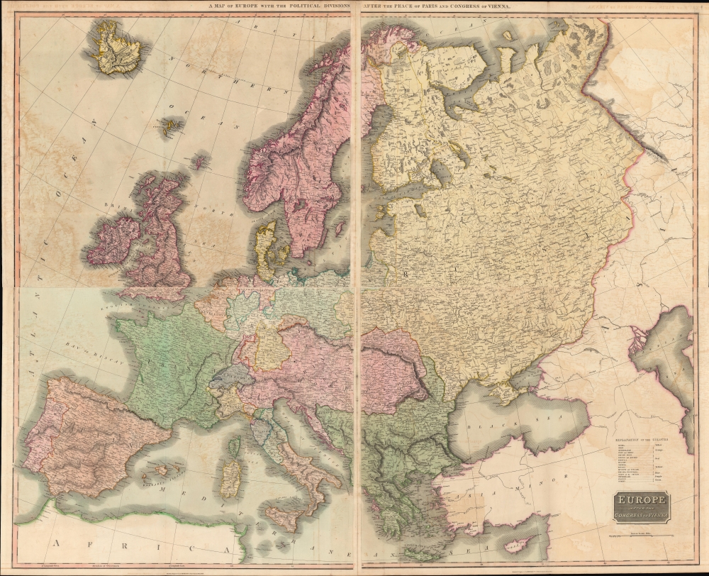
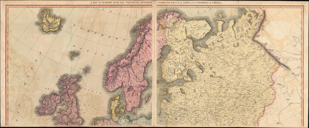
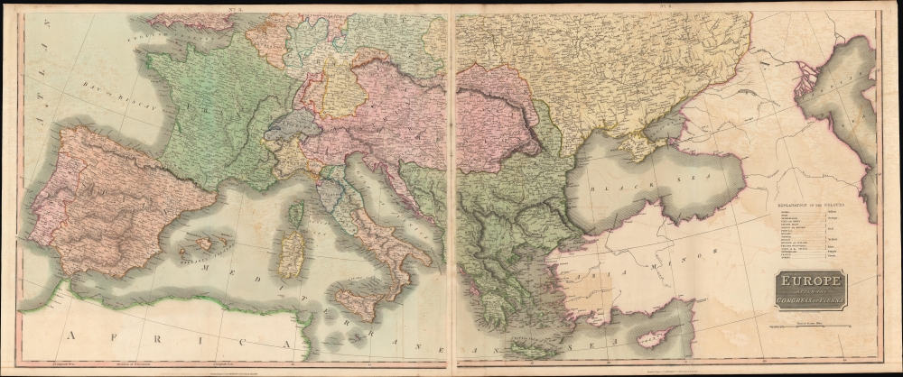
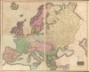
1816 Thomson Four-Sheet Wall Map of Europe after the Congress of Vienna
CongressOfVienna-thomson-1816$950.00


Title
A Map of Europe with the Political Divisions after the Peace of Paris and Congress of Vienna / Europe after the Congress of Vienna.
1816 (dated) 42 x 49 in (106.68 x 124.46 cm) 1 : 4050000
1816 (dated) 42 x 49 in (106.68 x 124.46 cm) 1 : 4050000
Description
A stunning map in four sheets (conjoined in twos to form a top and bottom half), this 1816 work by John Thomson depicting Europe in the wake of the Congress of Vienna clocks in at more than three feet tall by four feet wide. It represents the summation and apogee of Thomson's diligent and aesthetically-pleasing cartographic work in his New General Atlas.
This map can be compared to Thomson's smaller map of Europe from the same atlas (also sold by us), which was undoubtedly produced earlier and maintains the late Napoleonic borders of Europe, with some hint at their eventual rearrangement. Aside from the changes mentioned above, Germany is seen here as subdivided into kingdoms rather than unified in Confederation. Curiously, a large portion of northern Germany is displayed as 'British Dominions,' a reflection of the fact that the sovereign of the newly-created Kingdom of Hanover was also the British King George III.
The whole is beautifully engraved in the minimalist English style pioneered in the early part of the 19th century. A table above the title of the bottom sheet explains the colors employed, distinguishing the domains of different empires. Thomson maps are known for their stunning color, awe-inspiring size, and magnificent detail, and they represent some of the finest cartographic art of the 19th century.
A Closer Look
This lovely hand-colored map displays the continent of Europe with the borders determined at the Congress of Vienna at the end of the Napoleonic Wars. The negotiations, which lasted nearly a year, with interruptions due to Napoleon's escape from exile and the Battle of Waterloo, resulted in a redrawn map of Europe. Most notably, Poland was partitioned between Austria, Prussia, and Russia, which emerged from the conflict in a much-enhanced position in Europe,. The appearance of the short-lived United Kingdom of the Netherlands here is also significant; it would cease to exist 15 years later following a successful independence movement in Belgium.This map can be compared to Thomson's smaller map of Europe from the same atlas (also sold by us), which was undoubtedly produced earlier and maintains the late Napoleonic borders of Europe, with some hint at their eventual rearrangement. Aside from the changes mentioned above, Germany is seen here as subdivided into kingdoms rather than unified in Confederation. Curiously, a large portion of northern Germany is displayed as 'British Dominions,' a reflection of the fact that the sovereign of the newly-created Kingdom of Hanover was also the British King George III.
The whole is beautifully engraved in the minimalist English style pioneered in the early part of the 19th century. A table above the title of the bottom sheet explains the colors employed, distinguishing the domains of different empires. Thomson maps are known for their stunning color, awe-inspiring size, and magnificent detail, and they represent some of the finest cartographic art of the 19th century.
Publication History and Census
This map was engraved in 1816 by Samuel John Neele for the 1817 edition of Thomson's New General Atlas, which went through multiple printings in Edinburgh, London, and Dublin between 1815 and 1817. This four-sheet map appears to be much rarer than the other maps in Thomson's atlas, suggesting that it was not included in all printings. Although the top or bottom half appear on the market occasionally, the full map of four sheets in two conjoined halves is scarce to the market.CartographerS
John Thomson (1777 - c. 1841) was a Scottish cartographer, publisher, and bookbinder active in Edinburgh during the early part of the 19th century. Thomson apprenticed under Edinburgh bookbinder Robert Alison. After his apprenticeship, he briefly went into business with Abraham Thomson. Later, the two parted ways, John Thomson segueing into maps and Abraham Thomson taking over the bookbinding portion of the business. Thomson is generally one of the leading publishers in the Edinburgh school of cartography, which flourished from roughly 1800 to 1830. Thomson and his contemporaries (Pinkerton and Cary) redefined European cartography by abandoning typical 18th-century decorative elements such as elaborate title cartouches and fantastic beasts in favor of detail and accuracy. Thomson's principle works include Thomson's New General Atlas, published from 1814 to 1821, the New Classical and Historical Atlas of 1829, and his 1830 Atlas of Scotland. The Atlas of Scotland, a work of groundbreaking detail and dedication, would eventually bankrupt the Thomson firm in 1830, at which time their plates were sequestered by the court. The firm partially recovered in the subsequent year, allowing Thomson to reclaim his printing plates in 1831, but filed again for bankruptcy in 1835, at which time most of his printing plates were sold to A. K. Johnston and Company. There is some suggestion that he continued to work as a bookbinder until 1841. Today, Thomson maps are becoming increasingly rare as they are highly admired for their impressive size, vivid hand coloration, and superb detail. More by this mapmaker...
Samuel John Neele (July 29, 1758 - May 13, 1824) was a prolific British map engraver active in the late 18th and early 19th centuries. Neele apprenticed as a printer and engraver with Harry Ashby from about 1781 to 1782 before establishing himself independently in 1785 at 352 Strand, London. The combination of business acumen and technical skill made Neele extremely successful with literally hundreds of maps to his credit. His vast corpus was composed of notable maps by most major English publishers of the period including, Haywood, Faden, Wallis, Stockdale, Arrowsmith, Thomson, Pinkerton, and Greenwood, among others. Neele's sons, James and Josiah Neele, also engravers, took over their fathers business around 1818, both becoming notable in their own right. Learn More...
Source
Thomson, J., A New General Atlas, (Edinburgh) 1817.
Thomson's New General Atlas was first published in 1817 and continued to be published until about 1821. This is the first of Thomson's major cartographic works and the atlas for which is most celebrated. The New General Atlas follows in the Edinburgh School, which eschews excessive decoration in favor of a more minimalistic fact-based cartographic vision, as established by John Pinkerton, Laurie and Whittle, John Cary, and others in the previous decades. The maps are notable for their massive scale, heavy stock, elegant color work, and easy-to-read typefaces. Although the atlas stopped being published after 1821, Thomson continued to offer 'supplementary' maps that could be tipped into the atlas as late as 1830, when he declared bankruptcy. The maps in the Thomson Atlas were engraved by Thomas Clerk, William Dassauville, Nathaniel Rogers Hewitt, James Kirkwood, Robert Kirkwood, John Menzies, George Menzies, Edward Mitchell, John Moffatt, Samuel John Neele, Robert Scott, and James Wyld.
Condition
Good. Light foxing and soiling. Offsetting, most noticeable in the top-left sheet.
References
Rumsey 1007.037.