1846 Bradford Map of Connecticut
Connecticut-bradford-1846$250.00

Title
Connecticut.
1846 (dated) 12 x 14.5 in (30.48 x 36.83 cm) 1 : 460000
1846 (dated) 12 x 14.5 in (30.48 x 36.83 cm) 1 : 460000
Description
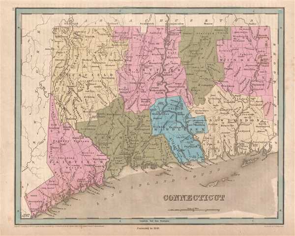
This is an 1846 Thomas G. Bradford map of Connecticut. The map depicts the region from New York to Rhode Island and from Massachusetts to Long Island Sound. As is the case among many maps from Bradford's A Universal Illustrated Atlas, the recently constructed rail network throughout Connecticut is highlighted.
Railroads in Connecticut
The oldest railroad in the state, the Hartford and New Haven Railroad, was chartered in 1833 and is illustrated here between Hartford and New Haven but is simply labeled 'Rail Road'. This is due to the fact that the Hartford and New Haven merged with the Hartford and Springfield Railroad in 1845, the year before this map was published. The Hartford and Springfield runs north from Hartford and is labeled here, but, as the Hartford and New Haven was technically an extension of this line, it is probable that Bradford elected to not label both lines with the same name. In 1846, the New York and New Haven Railroad, meant to connect New Haven and New York City, was still under construction. The line would not open until 1849 but accomplished what many believed to be a difficult task. The New York and New Haven built along the shore of Long Island Sound, which, due to the many rivers that emptied into Long Island Sound, many believed to be an overly difficult task. When this line was opened, it created a much more direct route between New York and Boston, avoiding a trip north via the New York Central or Boston and Albany lines, or a trip by steamship along the Sound to a harbor in Connecticut, Rhode Island, or Massachusetts. These three lines would merge into the New York, New Haven, and Hartford Railroad in 1872. The Housatonic Railroad, chartered in 1836, is also illustrated near the Connecticut-New York state line. The Housatonic operated from 1840 until 1971, on one form or another. A new Housatonic Railroad was incorporated in 1983 and operated 2011.
Like all of Bradford's maps, each county is illustrated, labeled, and shaded a different color to allow for easy differentiation. Individual townships are also labeled, along with numerous cities and towns, such as Hartford, New Haven, and New London. The Farmington Canal, a private canal built to provide water transportation from New Haven to Hartford and beyond, is also illustrated.
This map was engraved by George Boynton and published in the 1846 edition of Bradford and Goodrich's A Universal Illustrated Atlas.
CartographerS
Thomas Gamaliel Bradford (1802 - 1887) was born in Boston, Massachusetts, where he worked as an assistant editor for the Encyclopedia Americana. Bradford's first major cartographic work was his revision and subsequent republishing of an important French geography by Adrian Balbi, Abrege de Geographie published in America as Atlas Designed to Illustrate the Abridgment of Universal Geography, Modern and Ancient. Afterwards Bradford revised and expanded this work into his own important contributions to American cartography, the 1838 An Illustrated Atlas Geographical, Statistical and Historical of the United States and Adjacent Countries. Bradford's cartographic work is significant as among the first to record Texas as an independent nation. In his long career as a map publisher Bradford worked with William Davis Ticknor of Boston, Freeman Hunt of New York, Charles De Silver of Philadelphia, John Hinton, George Washington Boynton, and others. We have been able to discover little of Bradford's personal life. More by this mapmaker...
George Washington Boynton (fl. c. 1830 - 1850) was a Boston based cartographer and map engraver active in the first half of the 19th century. Boynton engraved and compiled maps for numerous publishers including Thomas Bradford, Nathaniel Dearborn, Daniel Adams, and S. G. Goodrich. His most significant work is most likely his engraving of various maps for Bradford's Illustrated Atlas, Geographical, Statistical, and Historical, of the United States and the Adjacent Countries and Universal Illustrated Atlas. He also engraved for the Boston Almanac. In 1835, Boynton is listed as an employee of the Boston Bewick Company, an engraving, stereotype, and printing concern based at no. 47 Court Street, Boston. Little else is known of his life. Learn More...
Source
Bradford, T. G. and Goodrich, S. G., A Universal Illustrated Atlas, exhibiting a Geographical, Statistical, and Historical view of the World, (Boston: Charles D. Strong) 1846.
The Universal Illustrated Atlas is one of the great American atlases of the first half of the 19th century. The atlas was first published in 1838 under the imprint of Charles D. Strong. It replaced and superseded Bradford's earlier smaller format Illustrated Atlas, Geographical, Statistical, and Historical, of the United States and the Adjacent Countries. Numerous reissues of the Universal Illustrated Atlas followed until about 1848. Although there are minor variations between the editions, most contain about 50 maps, the majority of which focus on the United States. Bradford's atlases are significant for recording North America during the Republic of Texas Era. In later editions, particularly the 1846 edition, Bradford illustrates the boom in railroad construction, possibly with the idea that his maps would aid travelers in planning journeys by rail. It was compiled by Thomas Gamaliel Bradford and Samuel Griswold Goodrich with most of the plates engraved by George Washington Boynton (fl. c. 1830 - 1850). Other contributors include Thomas Gordon (1778 - 1848), Fielding Lucas Jr. (1781 - 1854), Samuel Edward Stiles (1844 - 1901), Sherman and Smith (fl. c. 1829 - 1855), and Horace Thayer (1811 - c. 1874).
Condition
Very good. Even overall toning. Blank on verso.
References
Rumsey 0089.013 (1838 edition).