1859 Clark and Tackabury Wall Map of Connecticut
Connecticut-clarktackabury-1859$1,500.00

Title
Clark and Tackabury's New Topographical Map of the State of Connecticut.
1859 (dated) 57 x 73 in (144.78 x 185.42 cm) 1 : 95040
1859 (dated) 57 x 73 in (144.78 x 185.42 cm) 1 : 95040
Description
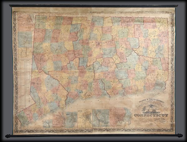
A 1859 first-edition example of Richard Clark and Robert and George Tackabury's important wall map of Connecticut. When published, it was by far the best and largest map of the state obtainable.
A Closer Look
The map covers the entire state of Connecticut with impressive detail, including topography, color coding by county and township, notes on railroad lines, rivers, and roads, and countless depth soundings along the Long Island Sound. There are multiple insets of Connecticut cities. Drawn on a scale of 1.5 miles to the inch, Clark and Tackabury's map purports to be the most complete map of Connecticut ever published, identifying 'the location of all public buildings, churches, school-houses, manufacturing establishments, and private residences'. Nine insets focus on the cities of Norwalk, New London, Bridgeport, Hartford, Norwich, Middleton, Waterbury, Norwich, Waterbury, Stamford, and New Haven, where Yale College is identified. To the left of the map proper are 1850 census population statistics for both counties and cities arrayed in a table.Publication History and Census
The cartography is an amalgam of older maps and new private survey work produced by G. M. Hopkins and Company of Philadelphia. The countless depth soundings along the Long Island Sound are drawn from the U.S. Coast Survey. This is one of the last great wall maps of Connecticut in the 19th-century. It was printed in Philadelphia and sold by subscription in both wall and case format from March 2, 1859.CartographerS
Richard Clark (fl. c. 1850 - 1865) was an American cartographer active in the middle part of the 19th century. Though he seems to have been based in Philadelphia, most of Clark's work was compiled in conjunction with other publishers and focused on Connecticut and Massachusetts. Clark is associated with several maps, but his most important are a wall map of Fairfield County, Connecticut, and Connecticut itself. Little is known of Clark's life. More by this mapmaker...
Robert Middleton Tackabury (1826-1906) and George Neusum Tackabury (1828 - 1894) were Philadelphia-based map publishers active in the middle part of the 19th century. The Tackaburys were born in New York. They published several case maps, pocket maps and atlases in conjunction with Robert Clark and Henry Francis Walling. The firm had actually been founded by the father of Robert M. and George N. Tackabury named James Tackabury (1795-1884), with his own brother John Wesley Tackabury (1804-1877) who emigrated from Ireland to Madison County, NY in 1807. James Tackabury had three sons who all worked for the firm at different points in their life; Robert Middleton Tackabury, George Neusum Tackabury, and Rev. Samuel T. Tackabury (1832-1888). His brother John Wesley Tackabury moved from New York to London, Upper Canada (future Ontario) and may have been involved in Tackabury's output of maps and atlases of Canada in the 1860s and early 1870s (Robert and George Tackabury established an office in London in 1860). Meanwhile, the New York Tackabury's established an office in Philadelphia in the late 1850s, though it is unclear if and for how long either brother actually resided in the city. Beginning in the 1870s, the Tackabury brothers began to shift focus towards maps, atlases, and business directories of states in the American Midwest and new states/territories in the Great Plains. George Tackabury remained in Madison County, new York for the rest of his life, while brother Robert traveled widely, moving to Syracuse, New York around 1870, then to Detroit, Michigan in the mid-1870s, and seems to have moved between Madison County, Syracuse, and Detroit for several years before moving to South Dakota in the mid-1890s and briefly to Los Angeles late in life, probably for health reasons. The firm published under George's name only from the late 1870s, but its continued output of maps related to Michigan and South Dakota strongly suggests Richard's continued involement. The firm's last known publication was an 1893 updated edition of an 1884 map of the Upper Peninsula of Michigan, 'Map showing the military road lands belonging to the estate of James C. Ayer'. Learn More...
Griffith Morgan Hopkins (George M. Hopkins, G. M. Hopkins; 1834 - September 23, 1901) was an American Civil Engineer active in Philadelphia. Hopkins was born in Camden, New Jersey, and spent most of his career in Philadelphia. His earliest known map is the 1859 Clark and Tackabury map of Connecticut. He is also credited with work on the well-known Kitchell map of New Jersey (1860). In 1865, he partnered with his brother, Henry W. Hopkins (1838 - 1920), to found G.M. Hopkins and Company. This prosperous firm issued numerous plat maps and atlases of American cities and counties, most along the eastern seaboard. Hopkins retired from the firm in 1901 and died one year later. The firm was taken over by his brother, Henry, who himself retired in 1902. G. M. Hopkins went through numerous subsequent owners and remains active to this day. Learn More...
Thomas S. Wagner and M'Guigan (fl. 1846 - 1858) were Philadelphia based publishers and lithographers active in the mid 19th century. The Wagner and M'Guigan (or McGuigan) firm were general interest lithographers and as such their work consisted of portraits, bookplates, advertisements and views as well as map. The firm was also an early pioneer of color lithography and for this were awarded a Silver Medal by the Franklin Institute in the 1840s. The Wagner and M'Guigan firm succeeded the Pinkerton, Wagner and M'Guigan firm. Learn More...
Condition
Good. Professionally restored and backed with fresh linen. Original rollers. Part of top border missing - see image. Measurement includes rollers.
References
Thompson, E., Maps of Connecticut for the Years of the Industrial Revolution, #181.