1875 Tilden Pocket Map of Connecticut - amazing condition
Connecticut-tilden-1875
Title
1875 (dated) 21.25 x 27.75 in (53.975 x 70.485 cm) 1 : 285120
Description
A Closer Look
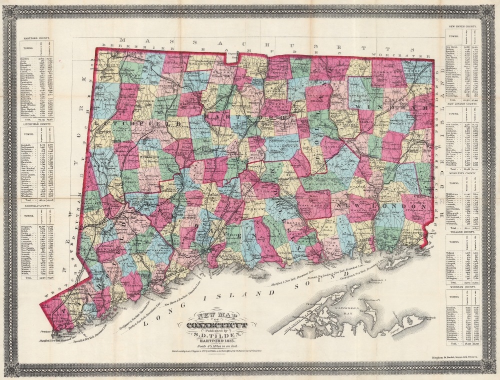
Strong color highlights townships across Connecticut. Connecticut's extensive railroad network is detailed, including the Boston, Hartford, and Erie Railroad; the New York, New Haven, and Hartford Railroad; the Connecticut Western Railroad; and the Hartford, Providence, and Fishkill Railroad. Proposed new railroads are marked by dashed black lines. Steamboat lines connecting Norwalk, Bridgeport, Derby, New Haven, Hartford, Norwich, New London, and Stonington with New York City are noted in Long Island Sound. The northeastern most part of Long Island is included along the bottom border with Greenport, Sag Harbor, Shelter Island, and Montauk named. Tables line the left and right borders and detail Connecticut's counties, providing census data for both 1860 and 1870.Publication History and Census
This map was published by Samuel D. Tilden and printed in 1875 by Bingham and Dodd. It is well represented in institutional collections. The present example is the cleanest examples to appear on the private market in years. Most known examples varnished and suffer related typical condition issues. The present example is an exception in that it has never been varnished and retains bright original color and strong paper integrity. If this map is on your radar, this is the one you want.CartographerS
Samuel D. Tilden (July 28, 1828 - July 13, 1893) was an American publisher. Tilden was a partner in the New York City based map publishing firm Baker and Tilden which was active in the 1850s. The partnership then reappears in the Hartford, Connecticut 1869 city directory. He was living in Colchester in 1870 and died in Hartford on July 13, 1873. More by this mapmaker...
John Henry Bingham (March 7, 1831 - June 10, 1910) was an American lithographer. Born in New York, Bingham and John Kelley formed the partnership Bingham and Kelley which was active in 1857 and 1858. Bingham then went into business with William H. Dodd in 1860 in Hartford. In 1861, Bingham, Dodd, and Company advertised in the Hartford, Connecticut City Directory, stating that they printed labels for druggists and prefumers, views of buildings, portraits, and landscapes from nature as well as 'engravings on stone, of checks, notes, bill heads, certificates of stock, circulars, maps, charts, etc.'. That partnership lasted until 1884. By 1900, he and his family then moved to Chicago, where he continued to work as a lithographer. He married Anna Maria Ehret (1835 - 1909) on February 19, 1854, with whom he had thirteen children. Learn More...
William H. Dodd (May 25, 1826 - February 20, 1914) was a Hartford, Connecticut based lithographer and publisher. He operated the firm Bingham and Dodd with John H. Bingham (1831 - 1910) from 1860 until 1884 and then started his own firm, William H. Dodd and Company, which operated in Hartford until around 1910. Learn More...


