1946 Survey of Palestine Map of Convoy Routes in British Mandatory Palestine
ConvoyRoutesPalestine-survey-1946$800.00

Title
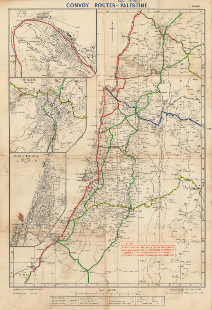
Convoy Routes - Palestine.
1946 (dated) 23 x 15 in (58.42 x 38.1 cm) 1 : 500000
1946 (dated) 23 x 15 in (58.42 x 38.1 cm) 1 : 500000
Description
This is a 1946 Survey of Palestine map of British Mandatory Palestine highlighting British Army convoy routes. This map captures an ephemeral period near the end of World War II (1939 - 1945), where the British in Palestine were combating several hardline Zionist paramilitary insurgencies. Convoy routes throughout Palestine were the key to maintaining regional control and a frequent target for insurgents hoping to destabilize British dominance.
A Closer Look
The map depicts the entirety of Mandatory Palestine from Sarafand south to Beersheba, Rafah, and the Sinai Peninsula in Egypt, and from the Mediterranean Sea to Amman and Irbid in Jordan (Transjordan) and Quneitira in Syria. A railroad travels up the Mediterranean coast and spurs head east to connect with Jerusalem, Nablus, and Beisan, and then heads east off the map towards Daraa. Insets along the left border highlight Haifa, Jerusalem, Jaffa, and Tel Aviv.British Convoys
Bold multicolored overprinted lines highlight six convoy routes linking major cities. A note in the lower-right statesConvoy routes are indicated on the road by coloured signposts at important or difficult turnings and crossroads and by periodic colouring of milestones etc. where necessary.A manuscript notation to the left of Gaza notes the headquarters of the Royal Army Service Corps (RASC). The RASC was responsible for transporting supplies and securing convoys in British Mandatory Palestine - a key to maintaining regional control. The previous owner's name, Captain H. Hamersley, is handwritten in the upper margin, suggesting that he may have served with the RASC.
Zionist Insurgency in Mandatory Palestine
The Jewish Insurgency in Mandatory Palestine began in February 1944 and continued until May 1948. Three Jewish paramilitary groups, the Haganah, Lehi, and Irgun, carried out an insurgent campaign against British Mandatory Palestine with the goal of opening unrestricted Jewish immigration. These insurgent groups occasionally coordinated but more often fought amongst themselves. The groups each carried out attacks on British military and police targets, including immigration posts, police stations, the railway network, and other targets. The insurgency only came to an end after the British set a final withdrawal date, May 15, 1948.Publication History and Census
This map was initially compiled, drawn, and printed by the Survey of Palestine in 1940 and revised and printed in October 1945. The present edition was printed by the Sarafand Section, 512 Field Survey Company Royal Engineers, in April 1946. This is the only known cataloged example of the present edition. The base map was first published in 1933 by the Survey of Palestine as the Survey of Palestine Motor Map.Cartographer
The Survey of Palestine (1920 - 1948) was a department of the government of the British Mandate of Palestine that surveyed and mapped Palestine. Established in 1920, the Survey moved from Jaffa to Tel Aviv in 1931. The Zionist Organization (now the World Zionist Organization) pressured the Survey to begin triangulation surveys of Palestine from its creation with the goal of using the surveys to identify land in Palestine that the Organization could acquire. For this reason, Palestinian Arabs resisted the Survey's efforts, since they viewed its projects as efforts to sell their land out from under them. The survey completed the national triangulation framework in 1930 and the 1:10,000 survey in 1934. In 1940 the government relieved the Survey of its responsibility to adjudicate land settlement claims, which allowed the department to focus on surveying. The department had finalized topographical maps for all of Palestine except the southern Negev by the 1947-1949 Palestine war. The British Mandate appointed a temporary Director General of the Survey Department for the both the forthcoming 'Jewish State and 'Arab State' in early 1948 under the terms of the United National Partition Plan for Palestine. More by this mapmaker...
Condition
Good. Soiling. Wear along original fold lines. Verso repairs to fold separations and at fold intersections. Some very small areas of loss along fold lines and at fold intersections. Closed edge tears professionally repaired on verso.