1921 U.S. Geological Survey of Cook Inlet Oil Fields, Alaska
CookInletOilFields-usgs-1921$250.00

Title
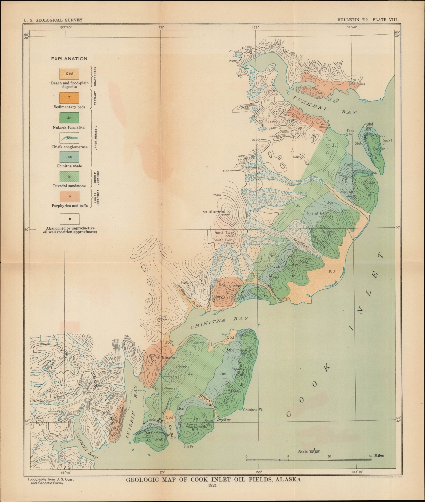
Geologic Map of Cook Inlet Oil Fields, Alaska.
1921 (dated) 14.5 x 11.75 in (36.83 x 29.845 cm) 1 : 250000
1921 (dated) 14.5 x 11.75 in (36.83 x 29.845 cm) 1 : 250000
Description
A colorful map of the southwestern portion of the Cook Inlet in Alaska produced in 1921 by the U.S. Geological Survey. This period saw a thorough exploration of the Alaskan coast for large-scale oil and gas deposits, which were eventually discovered and exploited in the Cook Inlet Basin several decades later.
A Closer Look
Coverage includes a portion of the Cook Inlet between Tuxedni Bay and Iliamna Bay, southwest of Anchorage. Color shading is used to distinguish different types of rock, which are explained and organized at left according to geologic era. Elevation is shown by contour lines and marked in feet at peaks. Bays, coastal points, hills, mountains, waterways, and abandoned oil wells are noted.Oil and Gas Production in the Cook Inlet Basin
This map was produced during an intermediary period, following the initial oil and gas explorations of the early 20th century, but before a second wave of exploration and limited commercial-scale production began in the mid-20th century. As was the case elsewhere along the coast of Alaska, oil and gas seeps were discovered here in the first decade of the century (especially around Oil Bay here) but were not able to sustain large-scale production. Further explorations were made in the 1950s and 1960s which likewise did not result in hoped-for production, though some geologists believe that the region may still be able to sustain commercial oil and gas production. Further into the Cook Inlet, just north and east of the area shown here, large-scale gas and oil deposits have been exploited since the 1950s.Publication History and Census
This map was produced by the U.S. Geological Survey in 1921, borrowing topographical information from the U.S. Coast and Geodetic Survey, to accompany the text 'Preliminary Report on Petroleum in Alaska' by G. C. Martin that appeared in the survey's Bulletin. It is only independently cataloged among the holdings of the University of Calgary and the Sorbonne Université, while the entire report and the full 1921 issue of the Bulletin are more widely distributed.CartographerS
The United States Geological Survey (1878 - Present), aka the U.S.G.S., is a scientific agency of the United States government, which was founded in 1879. USGS scientists study the landscape of the United States, its natural resources, and the natural hazards that threaten it. The organization has four major science disciplines: biology, geography, geology, and hydrology. It is a bureau of the United States Department of the Interior and is the department's only scientific agency. More by this mapmaker...
The Office of the Coast Survey (1807 - present) founded in 1807 by President Thomas Jefferson and Secretary of Commerce Albert Gallatin, is the oldest scientific organization in the U.S. Federal Government. Jefferson created the "Survey of the Coast," as it was then called, in response to a need for accurate navigational charts of the new nation's coasts and harbors. The spirit of the Coast Survey was defined by its first two superintendents. The first superintendent of the Coast Survey was Swiss immigrant and West Point mathematics professor Ferdinand Hassler. Under the direction of Hassler, from 1816 to 1843, the ideological and scientific foundations for the Coast Survey were established. These included using the most advanced techniques and most sophisticated equipment as well as an unstinting attention to detail. Hassler devised a labor intensive triangulation system whereby the entire coast was divided into a series of enormous triangles. These were in turn subdivided into smaller triangulation units that were then individually surveyed. Employing this exacting technique on such a massive scale had never before been attempted. Consequently, Hassler and the Coast Survey under him developed a reputation for uncompromising dedication to the principles of accuracy and excellence. Unfortunately, despite being a masterful surveyor, Hassler was abrasive and politically unpopular, twice losing congressional funding for the Coast Survey. Nonetheless, Hassler led the Coast Survey until his death in 1843, at which time Alexander Dallas Bache, a great-grandson of Benjamin Franklin, took the helm. Bache was fully dedicated to the principles established by Hassler, but proved more politically astute and successfully lobbied Congress to liberally fund the endeavor. Under the leadership of A. D. Bache, the Coast Survey completed its most important work. Moreover, during his long tenure with the Coast Survey, from 1843 to 1865, Bache was a steadfast advocate of American science and navigation and in fact founded the American Academy of Sciences. Bache was succeeded by Benjamin Pierce who ran the Survey from 1867 to 1874. Pierce was in turn succeeded by Carlile Pollock Patterson who was Superintendent from 1874 to 1881. In 1878, under Patterson's superintendence, the U.S. Coast Survey was reorganized as the U.S. Coast and Geodetic Survey (C & GS) to accommodate topographic as well as nautical surveys. Today the Coast Survey is part of the National Oceanic and Atmospheric Administration or NOAA as the National Geodetic Survey. Learn More...
Source
Martin, G., Preliminary Report on Petroleum in Alaska, (U.S. Geological Survey Bulletin 719, Washington, D.C.: Government Printing Office) 1921.
Condition
Good. Wear along original fold lines. Verso repairs to fold separations and at fold intersections. Light offsetting.
References
OCLC 150513304, 493296240.