This item has been sold, but you can get on the Waitlist to be notified if another example becomes available, or purchase a digital scan.
1859 Roche-Poncié Chart of the Korean Peninsula
Coree-rocheponcie-1859$1,500.00

Title
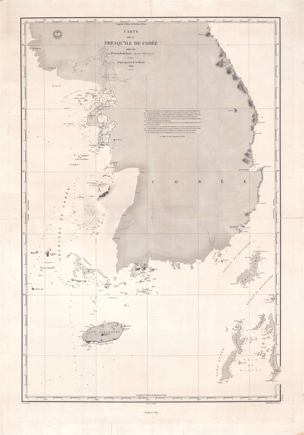
Carte de la presqu'île de Corée.
1859 (dated) 34.5 x 23 in (87.63 x 58.42 cm) 1 : 710000
1859 (dated) 34.5 x 23 in (87.63 x 58.42 cm) 1 : 710000
Description
This is a fine potentially unique example of the 1859 edition of Ferdinand de la Roche-Poncié's chart of Korea, the first scientifically surveyed chart of the southern half of the peninsula. It depicts the Korean coastline from the Ongjin Peninsula on the western side of the peninsula to Mt. Kumgang (here as Siedlovaia) on the eastern side.
Soundings are provided at various points along the coast, particularly on the west. Handwritten annotations are included near the title at top-left, filling in Ganghwa Island and the Han River down to Seoul; in later editions of the map, these have been engraved and printed. The dashed line marked 'Route des navaries' is likely Roche-Poncié's own ship, the Sabine, and/or other ships under the command of Admiral Guérin. Aside from the Ganghwa-Seoul region, special detail is also provided around important ports such as Busan (Havre Chosan) and Pohang (Unkovskago), bays, and islands.
Joseon's rulers had reason to be concerned, as missionaries commonly presaged a colonial presence, as in Vietnam. The French were especially prone to such tactics, as they lacked the commercial power of the British but had a surplus of zealous missionaries. From 1862 until his death in 1898, one of the leading figures in Korean politics was the regent Heungseon Daewongun, anti-Christian hardliner who recognized the chaos in China as a warning against foreign influence. In 1865, he launched a crackdown and executed seven French missionaries along with many Korean Catholics. In response, France launched a punitive military expedition, but were held off for six weeks by the Korean garrison at Ganghwa Island, which protects the Han River flowing into Seoul. France's defeat was an embarrassment, further cementing their secondary role vis-à-vis the British in East Asia, and also seemingly confirmed Joseon's isolationist policies, with profound long-term consequences.
A Closer Look
Combining survey work done by Roche-Poncié, his sub-engineers, and other recent French and British explorers, this chart covers the Korean coastline along a stretch roughly concurrent with today's South Korea. The names of features along the coast reflect this multinational process of exploration, for example the Ile Quelpaert (Jeju Island) and Aukland Island (most likely Wando Island). Some placenames, such as Unkovskago for Yongil Bay off Pohang and Siedlovaia for Mt Kumgang, come from Russian, perhaps derived from second-hand accounts of Korea written by Russian ambassadors in Beijing. Other names, especially for coastal towns and cities (Chang-yuen, Ya-chan, Chou-yng, Fou-an, Yo-keou, etc.), look to be derived from Chinese but have been garbled in transliteration beyond recognition.Soundings are provided at various points along the coast, particularly on the west. Handwritten annotations are included near the title at top-left, filling in Ganghwa Island and the Han River down to Seoul; in later editions of the map, these have been engraved and printed. The dashed line marked 'Route des navaries' is likely Roche-Poncié's own ship, the Sabine, and/or other ships under the command of Admiral Guérin. Aside from the Ganghwa-Seoul region, special detail is also provided around important ports such as Busan (Havre Chosan) and Pohang (Unkovskago), bays, and islands.
Franco-Korean Relations
Although the 'hermit kingdom' moniker applied to Joseon Korea by Westerners was an exaggeration, there is no question that the Joseon were deeply concerned with limiting foreign influence and justly alarmed at the increasing number of foreign ships on Korea's shores. In particular, they opposed the influence of Christian missionaries, who often snuck into Korea and made inroads among Korea's large underclass, which the Confucian elite saw as politically and culturally subversive. Aside from contact with Korean diplomats and traders in Beijing, these missionaries (including Chinese Catholics who went to Korea and Koreans in China who converted to Christianity like Andrew Kim Taegon) were the primary source of direct information about Korea in the West from the 17th through the mid-19th century.Joseon's rulers had reason to be concerned, as missionaries commonly presaged a colonial presence, as in Vietnam. The French were especially prone to such tactics, as they lacked the commercial power of the British but had a surplus of zealous missionaries. From 1862 until his death in 1898, one of the leading figures in Korean politics was the regent Heungseon Daewongun, anti-Christian hardliner who recognized the chaos in China as a warning against foreign influence. In 1865, he launched a crackdown and executed seven French missionaries along with many Korean Catholics. In response, France launched a punitive military expedition, but were held off for six weeks by the Korean garrison at Ganghwa Island, which protects the Han River flowing into Seoul. France's defeat was an embarrassment, further cementing their secondary role vis-à-vis the British in East Asia, and also seemingly confirmed Joseon's isolationist policies, with profound long-term consequences.
Publication History and Census
This chart was drawn by Ferdinand de la Roche-Poncié with assistance from his sub-engineers Estignard and J. Delbalat, with text engraved by Jacques-Marie Hacq and nautical features engraved by Stanislas Joseph Jacobs. It was first published in 1848 for the Dépôt de la Marine and went through multiple editions afterwards, including the present one, an 1884 Russian edition, and an 1887 French edition (which included Tsushima and some other Japanese coastal islands). All of these are quite rare, and the present edition has no known institutional presence or history on the market.CartographerS
Ferdinand Antoine Jules de la Roche-Poncié (August 19, 1810 – March 30, 1881) was a French hydrographic engineer and cartographer active throughout the 19th century. Poncié was born in Vauxrenard, France. After graduating from the École Polytechnique in 1829 he joined the French navy, becoming a naval hydrographic engineer in 1832. Numerous important French surveys bear his name, including the first detailed hydrographic survey of the St. Pierre and Miquelon Islands, and numerous maps of East Asian waters. He received the Legion of Honor in 1841, ultimately attaining the grade of Commander. In 1860 he settled in Paris where he became a member of the Hydrographic Committee under Rear-Admiral Pierre Mathieu. He died in Paris in 1881. More by this mapmaker...
Jacques-Marie Hacq (September 22, 1785 – 18??) was a French letter and line engraver, and historian, active in Paris during the middle part of the 19th century. Hacq was born in Paris and trained under J. P. Besançon, who he succeeded at the Dépôt de la Guerre in 1830. He engraved for the Dépôt de la Guerre as early as 1830 and for the Dépôt des Cartes et Plans de la Marine from, at least, 1840 to 1852. In addition to his work for the French Government, he also completed maps and engravings for Lesage, Lapie, Dufour, Duperrez, Gouvion St. Cyr, and Dumont d'Urville. His historical works include a history of the Napoleonic Wars and a history of Paris under the reign of Louis XIII. During most of his career in Paris he lived at 58 Rue de la Harpe. Learn More...
Stanislas Joseph Jacobs (18?? – July 5, 1867) was a French line engraver active in Paris during the middle part of the 19th century. Jacobs did work for the both the Dépôt de la Guerre ad Dépôt de la Guerre and the Dépôt des Cartes et Plans de la Marine. He often worked with Jacques-Marie Hacq. His most important publication is most likely the Eugène Duflot de Mofras map of the American west, published in 1844. Stanislas was a member of the French Société de Géographie from 1842. In 1862 Stanislas' son, Alfred Joseph Jacobs (December 15, 1827 - July 16, 1889), also an engraver, descended into mental illness and was consigned the Charenton hospice. His son's illness apparently catapulted Stanislas into a deep unremitting despair. Stanislas retired in 1862. He was married to Thérèse Alexandrine Outrequin (January 28, 1804 – February 20, 1873). He lived in Paris at Rue De Condé, 1. Learn More...
Dépôt des Cartes et Plans de la Marine (fl. 1720 - present), often called the Dépôt de Marine, was a French hydrographic mapping organization founded in 1720 under Charles-Hercule of Albert de Luynes (1674 - 1734). Much like the U.S. Coast Survey, the British Admiralty, and the Spanish Deposito Hydrografico, the Dépôt was initiated as a storehouse and distribution center of existing nautical and marine charts. Eventually the Dépôt initiated its own mapping activities in an attempt to improve and expand upon existing material. Some of the more prominent cartographers and hydrographers associated with the of Dépôt des Cartes were, Philippe Buache, Jacques-Nicholas Bellin, Giovanni Rizzi-Zannoni, Rigobert Bonne, and Jean Nicolas Buache. Learn More...
Condition
Good. Fold lines visible and some wear at fold intersections. Creases in the bottom margin.