1704 / 1729 Joachim Ottens Map of Corfu
Corfu-ottens-1717$1,750.00
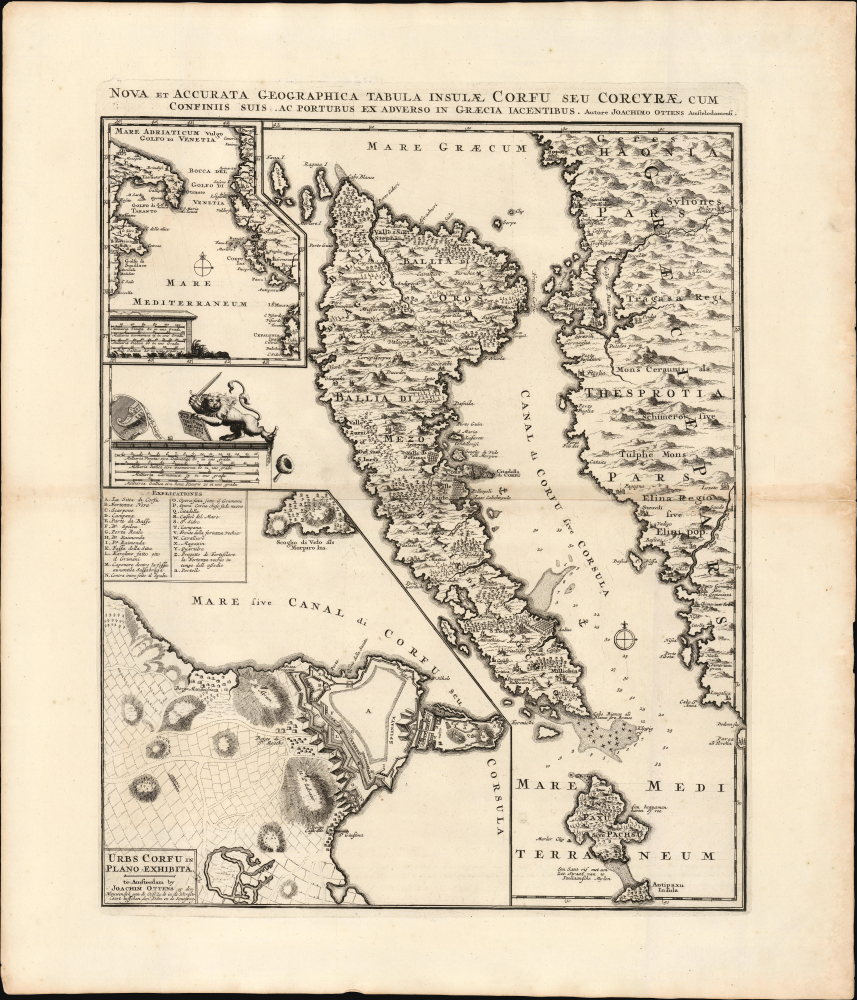

Title
Nova et Accurata Geographica Tabula Insulae Corfu seu Corcyrae cum Confinis suis ac Portubus ex Adverso in Graecia Iacentibus. Auctore Joachimo Ottens Amstelodami.
1717 (undated) 20.25 x 16 in (51.435 x 40.64 cm) 1 : 250000
1717 (undated) 20.25 x 16 in (51.435 x 40.64 cm) 1 : 250000
Description
This is Joachim Ottens' rare, beautiful 1717 map of Corfu. It was published in the wake of the famous 1716 Siege of Corfu; the victory is alluded to with the decorative element of the Venetian Lion of Saint Mark, sword upraised while kicking aside an Ottoman scimitar and turban. Ottens' map proved the canonical mapping of Corfu for the rest of the century.
The depth soundings of the southern approach to Corfu shown on this map do not appear on the 1672 Marmora. A surviving 1716 Gerard Van Keulen chart of Corfu is the likely source for these elements.
An inset in the upper left shows Corfu's strategic position, governing the passage between the Gulf of Venice and the Mediterranean Sea, bottlenecked between the Greek coastline and the boot-heel of Italy. The latter is presented based on the mapping of Magini, for better or for worse. While Magini's was the most accepted mapping of Italy throughout the 17th century, it contained a glaring error, reproduced here: the nonexistent island of Monte Sardo in the Gulf of Taranto.
The lower left inset focuses on the city and fort of Corfu, on the island's eastern shore. It lays out the old and new forts defending the city and harbor, and mainly follows the model followed by Joan Blaeu, prepared for his town book but not published until 1704 by Pierre Mortier. Ottens' copy includes the descriptive table keyed to the plan. But it includes a detailed depiction of a further stage of improvements to the city's walls, particularly an additional layer of glacises facing the land approaches of both the new fort and the old. This is important, as Venetian forces had been actively upgrading the defenses of the city in preparation for an Ottoman attack. By the time of the Second Ottoman Siege of Corfu in 1716, these defenses were complete. The Venetian victory is largely ascribed to their improvements to the city's defenses in advance of the war.
A Closer Look
The main map delineates the island of Corfu, with the Greek coastline to the west. Terrain is shown pictorially, as are salt pans, forests, and vineyards. As with most contemporaneous maps, it is derived from the foundational 1672 map by Andrea Marmora, but has been updated in several areas. Notably, the lake in the west of the island, appearing on Marmora's map and most of its derivatives, has here been replaced with vineyards. Historically, swampland had existed there, swelling to the depth of a lake; drainage projects over the course of the 18th century would result in the disappearance of the lake altogether.The depth soundings of the southern approach to Corfu shown on this map do not appear on the 1672 Marmora. A surviving 1716 Gerard Van Keulen chart of Corfu is the likely source for these elements.
An inset in the upper left shows Corfu's strategic position, governing the passage between the Gulf of Venice and the Mediterranean Sea, bottlenecked between the Greek coastline and the boot-heel of Italy. The latter is presented based on the mapping of Magini, for better or for worse. While Magini's was the most accepted mapping of Italy throughout the 17th century, it contained a glaring error, reproduced here: the nonexistent island of Monte Sardo in the Gulf of Taranto.
The lower left inset focuses on the city and fort of Corfu, on the island's eastern shore. It lays out the old and new forts defending the city and harbor, and mainly follows the model followed by Joan Blaeu, prepared for his town book but not published until 1704 by Pierre Mortier. Ottens' copy includes the descriptive table keyed to the plan. But it includes a detailed depiction of a further stage of improvements to the city's walls, particularly an additional layer of glacises facing the land approaches of both the new fort and the old. This is important, as Venetian forces had been actively upgrading the defenses of the city in preparation for an Ottoman attack. By the time of the Second Ottoman Siege of Corfu in 1716, these defenses were complete. The Venetian victory is largely ascribed to their improvements to the city's defenses in advance of the war.
Publication History and Census
This map was produced by Joachim Ottens in Amsterdam no earlier than 1716; after Joachim's 1719 death, the map likely remained in the atlases published by his sons Renier and Josue, but it is seldom on the market and appears in fewer than 20 institutional collections.CartographerS
a (Ανδρέας Μαρμοράς 1618 - 1684) was a Corfiote soldier, knight, and historian. The Marmoras family was an established noble family in Corfu, then part of the Republic of Venice. His first career was military; upon his retirement, he wrote a history of his home, which was published in 1672: Della historia di Corfu. The work contained a map of the island, Pianta Dell' Isola Di Corfu Con Parte Della Grecia, which would provide the basis for many maps of Corfu over the course of a century. More by this mapmaker...
Gerard van Keulen (1678 - 1726) was a Dutch map publisher and engraver active in Amsterdam during the late 17th and early 18th centuries. Gerard was the son of the more famous Johannes Van Keulen (1654 – 1715) and eventually took over his father's business. He also negotiated to take over the Privilege of Willem Blaeu, thus becoming the official cartographer of the Dutch East India Company (VOC). He was married to Ludowina Konst (16??? - 1740). Gerard is credited with nearly 500 charts and maps published between 1706 and his death in 1726. He also continued to update and republish his family's legendary Zee-Fakkel, often described as the 'Secret Atlas' as it was restricted to VOC pilots. After his death, the firm was passed on to Gerard's son, Johannes II Van Keulen (1704 - 1755), who significantly updated the atlas. The final true Van Keulen editions of the atlas were published by Gerard Hulst Van Keulen (1733 - 1801), Johannes II's son. The final edition of the Zee-Fakkel was published posthumously in 1803. Afterward, the firm fell into the hands of the Swart family, who managed it for several generations until it finally closed its doors in 1885. It is noteworthy that though ostensibly controlled by the Van Keulen men, it was their widows who maintained and managed the firm in the periods following their husbands' deaths. Learn More...
Ottens (fl. c. 1680 - 1785) was a prominent Amsterdam map publishing family active for nearly 100 years. Joachim Ottens (1663 - 1719) was born in Amsterdam to a family of seafarers and educated in Amsterdam's Evangelical Lutheran community. He likely learned copperplate engraving under Frederick de Wit (1629 - 1706), for whom he worked until about 1710. In 1710, he was admitted to the Sint-Lucasgilde (Guild of St. Luke) and, in 1711, Joachim founded his own firm. Although Joachim died only a few years later, in 1719, his widow continued the business, either publishing as either 'I. Ottens', 'Ottens', or 'In de Wereldcaert' [In the World Map]. In 1726, Joachim Otten's sons, Renier (1698 - 1750) and Joshua (1698 - 1750), established a partnership and generally published as 'R. and I. Ottens'. Although they ran separate shops, on Nieuwendijk and Kalverstraat, they worked jointly as a singular business until Renier's death in 1750, at which point Joshua assumed full control. After Joshua's death in 1765, his widow continued the firm with their son, Renier II, changing the imprint to 'Joshua and Reinier Ottens.' Joshua's widow, Johanna de Lindt, held an auction sale of their engraved plates in 1784. Ottens' work stands out in that all of their maps were separate issues, though often found compiled into special, made-to-order multi-volume composite Atlas factice works, such as the Atlas. Some examples of the Atlas include over 800 separately issued maps. Because they were not uniformly issued in standard atlases, Ottens maps are often of the utmost rarity and are notable for their exceptionally rich engraving. Learn More...
Condition
Very good. Marginal split not impacting image, else excellent.
References
OCLC 1062266921. Zacharakis, C. G., A Catalogue of Printed Maps of Greece 1477-1800 #2523.