This item has been sold, but you can get on the Waitlist to be notified if another example becomes available, or purchase a digital scan.
1889 Montes De Oca Ramirez Map of Costa Rica
CostaRica-montesdeoca-1889$325.00

Title
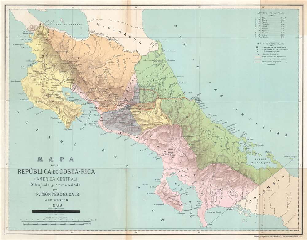
Mapa de la República de Costa-Rica (America Central).
1889 (dated) 16 x 20 in (40.64 x 50.8 cm) 1 : 1000000
1889 (dated) 16 x 20 in (40.64 x 50.8 cm) 1 : 1000000
Description
This is a rare 1889 Faustino Montes De Oca Ramírez map of Costa Rica illustrating plans for that country's first (and only) railroad.
Cities and towns, including San José, Cartago, and Heredia are labeled. Rivers are illustrated throughout the country, along with several volcanoes. A key in the upper right accompanies a table of the highest mountains in Costa Rica.
A Closer Look
A red line connecting Alajuela in the interior and Limon on the Caribbean highlightsThe map details Costa Rica's first railroad line, connecting Alajuela in the interior and Limon on the Caribbean. The railroad began operation on December 7, 1890. A secondary line from Alajuela to Tivives and Puntarenas illustrates the projected Pacific Extension, which opened on July 23, 1910.Cities and towns, including San José, Cartago, and Heredia are labeled. Rivers are illustrated throughout the country, along with several volcanoes. A key in the upper right accompanies a table of the highest mountains in Costa Rica.
Publication History and Census
This map was created by Faustino Montes De Oca Ramírez and engraved and printed by Georges Erhard in Paris in 1889. We note five examples in OCLC: Syracuse University, the Library of Congress, the University of Kansas, the Staatsbibliothek zu Berlin, and the Bibliothèque nationale de France.CartographerS
Faustino Montes De Oca Ramírez (October 9, 1859 - October 18, 1902) was a Costa Rican cartographer. The son of Prospero Montes de Oca and Gertrudis Ramirez, he married Juana Garnados Gomez on June 3, 1886, with whom he had two children. More by this mapmaker...
Georges Erhard Schièble (1823 – November 23, 1880) was a German printer active in Paris during the middle to late 19th century. Erhard was born in Forchheim, Baden-Württemberg, and relocated to Paris in his 16th year, where he apprenticed under his cousin, an engraver and mapmaker. In 1852, after 6 years with the Royal Printing Office, he started his own business. Around this time, he also became a naturalized French citizen. From his offices on Rue Bonaparte, he produced several important maps, and a detailed topography of Gaul for Napoleon III's History of Julius Caesar. In 1865 he took on larger offices expanding his operations to include a lithographic press. He was among the first to introduce printed color maps and pioneered photo-reduction, including the process known as Erhard reproduction. After Erhard's death in 1880, the firm was taken over by his sons and run under the imprint of 'Erhard Frères' until 1911. Learn More...
Condition
Very good. Light toning. Light wear along original fold lines.
References
OCLC 5478092, 494191008.