This item has been sold, but you can get on the Waitlist to be notified if another example becomes available, or purchase a digital scan.
1693 De Hooghe Map of the South Coast of England Including London
CostesAngleterre-dehooghe-1693$550.00

Title
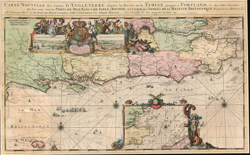
Carte Nouvelle des Costes d'Angleterre depuis la Riviere de la Tamise jusques à Portland, et des Isles Voisines: Ou l'on voit tous les Ports de Mer, Bancs de Sable et Rochers. A l'Usage des Armées de sa Majesté Britannique.
1693 (dated) 23.5 x 38 in (59.69 x 96.52 cm) 1 : 440000
1693 (dated) 23.5 x 38 in (59.69 x 96.52 cm) 1 : 440000
Description
This is a 1693 Romeyn de Hooghe map of the southern coast of England including the Thames estuary and London. The map depicts from the Isle of Portland east to the Thames estuary and from London to Aldernay, including the Isle of Wight. Cities and towns are labeled throughout. An inset along the bottom border focuses on southeastern England and the North Sea along with northeastern France around Calais and Dunkirk. A decorative cartouche appears in the upper left quadrant and includes views of Portsmouth and Rochester. Wonderfully decorated with compass roses and rhumb lines, this chart is part of a group of nine charts created by de Hooghe and published by Mortier, all of which are regarded as the most decorative sea charts of the 17th century.
Publication History and Census
This map was created by Romeyn de Hooghe and published by Pierre Mortier in 1693. Two examples are cataloged in OCLC and are part of the institutional collections at the Bavarian State Library and the National Library of Spain.CartographerS
Romeyn de Hooghe (Septemer 10, 1645 – June 10, 1708) was a Dutch engraver, portrait artist, caricaturist, painter, and sculptor active in Amsterdam during the second half of the 17th century and opening years of the 18th century. De Hooghe was born in Amsterdam and revealed an early talent for all forms of visual arts. He became known caricaturist and is admired today as one of the first great graphic satirists. During his life he was criticized for his proclivity towards humorous tongue-in-cheek subjects. He nonetheless developed a following and produced a prolific amount of work, some 5000 engravings. He was a member of the Confrerie Pictura in 1662 and 1683. Cartographically he is best known for his decorative border work. His disciples were Filibert Bouttats (1654-after 1731), Filibertus Bouttats (1635–1707), Frans Decker, François Harrewijn, Jacobus Harrewijn, Aernout Naghtegael, Laurens Scherm, and Adriaen Schoonebeek. De Hooghe died in Haarlem on June 10, 1708. Much of his work continued to be republished posthumously. More by this mapmaker...
Pierre Mortier (January 26, 1661 - February 18, 1711) or Pieter Mortier was a cartographer, engraver, and print seller active in Amsterdam during the later 17th and early 18th centuries. Mortier, then known as Pieter, was born in Leiden. He relocated to Paris from 1681 to 1685, adopting the French name Pierre, which he retained throughout his career. While in France, he developed deep French connections by bringing sophisticated Dutch printing technology and experience to nascent French map publishers such as Guillaume De L'Isle (1675 - 1726), Alexis-Hubert Jaillot (c. 1632 - 1712), and Nicholas de Fer (1646 - 1720). Consequently, much of Mortier's business was built upon issuing embellished high quality editions of contemporary French maps - generally with the permissions of their original authors. In the greater context of global cartography, this was a significant advantage as most Dutch map publishes had, at this point, fallen into the miasma of reprinting their own outdated works. By contrast, the cartographers of France were producing the most accurate and up to date charts anywhere. Mortier's cartographic work culminated in the magnificent nautical atlas, Le Neptune Francois. He was awarded the Privilege, an early form of copyright, in 1690. Upon Pierre's death in 1711 this business was inherited by his widow. In 1721, his son Cornelius Mortier took over the day to day operation of the firm. Cornelius partnered with his brother-in-law Jean Covens to form one of history's great cartographic partnerships - Covens and Mortier - which continued to publish maps and atlases until about 1866. Learn More...
Condition
Backed on archival tissue for stability. Exhibits verso repairs and reinforcements in lower left quadrant as well as some loss in the lower left near where it says 'La Mer'. Closed tear extending four inches into printed area from top left corner professionally repaired on verso. Verso reinforcement to left edge. Exhibits wear along original centerfold. Price reflects condition.
References
Rumsey 12095.051. OCLC 159834335.