1775 Mannevillette Nautical Chart or Map of the Coast of Burma (Myanmar)
CoteDePegou-mannevillette-1775-2$400.00

Title
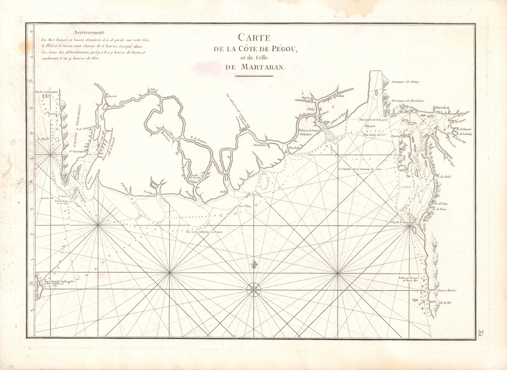
Carte de la Cote de Pegou et de Celle de Martaban.
1775 (undated) 13.5 x 19 in (34.29 x 48.26 cm) 1 : 1000000
1775 (undated) 13.5 x 19 in (34.29 x 48.26 cm) 1 : 1000000
Description
A scarce 1775 nautical chart or maritime map of the coast of Burma (Myanmar) in the Pegu (Bago) region composed by Jean-Baptiste d'Apres de Mannevillette for the 1775 edition of his magisterial Le Neptune Oriental.
A Closer Look
Coverage includes the Gulf of Martaban and the coast of Burma (Myanmar) from the Ayeyarwady region east as far as the city of Martaban (modern-day Mottama). The chart offers rich detail, including countless depth soundings, notes on the seafloor, hazard, commentary on reefs, rhumb lines, shoals, anchorages, place names, and a wealth of other practical information for the mariner. Coastal features including mountains, settlements, and temples are also indicated. The area marked here as 'Ragen' is likely Rangoon (Yangon) and the illustrated stupa the Shwedagon Pagoda.Publication History and Census
This chart was drawn by Jean-Baptiste d'Apres de Mannevillette for publication in the 1775 edition of his Neptune Oriental. The basic cartography of this map dates to Mannevillette's voyages as pilot for the Compagnie des Indies in the early 1700s. This chart did not appear in the 1745, whose coverage of this coast appeared on a much more general chart. This was one of the additions to the much-expanded 1775 second edition of Le Neptune Oriental. The scarcity of the 1745 atlas has led to frequent misdating of this work: five out of six listings of the chart in OCLC incorrectly date it 1745. The only listing dated 1775 or c. 1775 is with Leiden University.Cartographer
Jean-Baptiste Nicolas Denis d'Après de Mannevillette (February 11, 1707 - March 1, 1780) was a French sailor, navigator, and hydrographer active in the mid-18th century. Mannevillette was born in Le Havre to a family of wealthy seafarers. He completed his first major voyage at 12, when he accompanied his father, Jean-Baptiste-Claude d'Après de Blangy, a captain of the Compagnie des Indes (French East India Company) vessel Solide to Bengal. On his return to France, he he studied mathematics and navigation in Paris under Joseph Nicholas De L'Isle (1688 - 1768) before returning to the sea at 19 as a fourth officer as on the merchant vessel Marechel d'Estrees. Mannevillette himself eventually attained the rank of Captain with the Compagnie des Indes. In the course of numerous voyages around Africa to India and China, Mannevillette collected and revised numerous nautical charts. His sophisticated use of the most modern instruments, most specifically the Octant or English Quarter, and keen mathematical mind, enabled Mannevillette to correct many significant errors common to earlier maps. These updates were eventually compiled and published in Mannevillette's most significant work, the 1745 Le Neptune Oriental. The 1745 Neptune Oriental was commissioned by the Compagnie des Indes and its production earned Mannevillette admission into the Academy of Sciences. The atlas was well received, but shortly after publication, most unsold examples were destroyed by the French Admiralty, who considered the secrets of East Indian navigation too dangerous for dissemination. In 1762 the Compagnie des Indes appointed Mannevillette director of chart at Lorient. In 1767 King Louis XV conferred the Order of St. Michael upon him and made him an associate of the Royal Marine Academy. In the 30 years following his first publication of Le Neptune Oriental, Mannevillette worked doggedly with his lifelong friend, Alexander Dalrymple (1737 - 1808) to update his original work with new and improved charts. In 1775, he republished his opus in a greatly expanded format - by this time nautical information was less tightly guarded. Mannevillette died on March 1, 1780 at 75 years of age. More by this mapmaker...
Source
Mannevillette, Jean-Baptiste d'Apres de, Le Neptune Oriental, (Paris) 1775.
Le Neptune Oriental was a large-scale maritime atlas first issued in 1745 by Jean-Baptiste Nicolas Denis d'Après de Mannevillette, a wealthy French sailor and hydrographer. From his first voyage as an adult in 1726, Mannevillette collected, revised, and created new nautical charts. These he published 20 years later in the first edition of Le Neptune Oriental, an important work issued for the Compagnie des Indes (French East India Company), for whom Mannevillette was a captain. The first edition of Le Neptune Oriental containing 25 charts, was received and earned him accolade on both navigational and scientific circles. Nonetheless, according to Manonmani Filliozat, writing in the Indian Journal of the History of Science,
The French Admiralty considering that the Neptune Oriental was too dangerous ... ordered the remaining copies to be destroyed. (#292, 1994, p. 341)This accounts somewhat for the extreme scarcity of the first edition and all of the maps contained therein. We also note a supportive comment in a, 1763 catalog of maps and charts issued by the French chart and map dealer Roch-Joseph Julien (1745 - 1779). Mannevillette nonetheless continued to collect and revise charts for the next 30 years, often working with the important English cartographer Alexander Dalrymple (1737 - 1808). In 1775, he issued greatly expanded and updated second edition of Le Neptune Oriental. This time with an additional 41 charts, making a total of 63 charts. This edition also proved popular and was widely disseminated. As noted by multiple cartobibliographers, there are variations between examples and no two seem to be identical, suggesting that many were compiled to order, often with additional maps that could be purchased but which were not in the standard collation. The second edition was published in Paris by Demonville and in Brest by Malassis. In 1781, one year after Mannevillette's, another work, Supplement au Neptune Oriental was issued, also by Demonville and Malassis.
Condition
Good. Soiling in top margin. Foxing present, more prominent towards upper-left. Other imperfections in the margins and around the title text.
References
OCLC 1134991585.