
This item below is out of stock, but another example (left) is available. To view the available item, click "Details."
Details
1775 Sayer and Ross Map of the Mississippi River from the Gulf of Mexico to Fort Chartres
1775 (dated) $7,500.00
1775 Sayer and Ross Map of the Mississippi River from the Gulf of Mexico to Fort Chartres
CourseoftheRiverMississipi-sayer-1775$3,750.00

Title
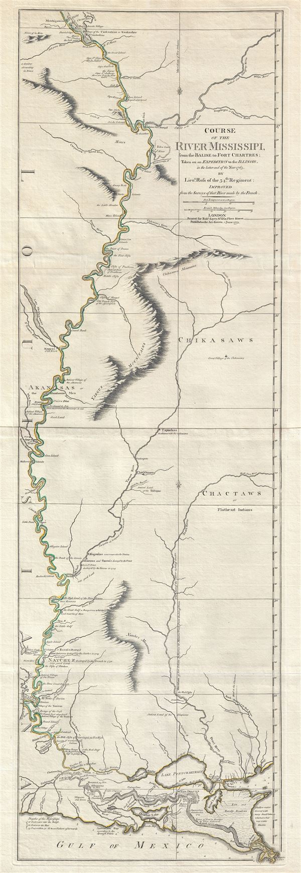
Course of the River Mississipi, from the Balise to Fort Chartres; Taken on an Expedition to the Illinois, in the latter end of the Year 1765.
1775 (dated) 45 x 14.5 in (114.3 x 36.83 cm) 1 : 870000
1775 (dated) 45 x 14.5 in (114.3 x 36.83 cm) 1 : 870000
Description
A scarce, important, and dramatic map of the Mississippi River Valley from the Gulf of Mexico to Fort Chartres (Illinois). Set on the meridian of New Orleans, this map covers the Mississippi Valley from the Delta of the Mississippi where it joins the Gulf of Mexico to Fort Chartres, located in present day Illinois just south of St. Louis, Missouri. The map also includes suburb detail of the lands to the immediate east of the Mississippi including numerous tributary rivers: the Pearl River, the Yasous River (Yazoo River), the Chickasaw River, and the Ohio River, among others. Also noted are various American Indian villages, old and abandoned fortifications, trading posts, mineral deposits, and other resources. Topography is rendered in profile.
Compiled by Lieut. John Ross of the 34th Foot Regiment, this map was commissioned immediately following the British acquisition of this territory at the end of the French and Indian War. Ross, who was trained as a field surveyor, was commanded to ascend the Mississippi from the Gulf of Mexico to Fort Chartres, the last French holdout in North America, where he was to accept the surrender of Commandant Louis Groston de Saint-Ange et de Bellerive. Along the way he made detailed notations and surveys which were later used by Sayer to update and revise the established French cartography as laid down by Jean Baptiste D'Anville.
Sayer published this work in his American Atlas, considered the most authoritative and comprehensive mappings of North America to date. His timing could not have been better, for a few years later, with the outbreak of the American Revolutionary War in 1776, both sides of the conflict relied on Sayer's large detailed maps to formulate strategies. After the war it took on even greater importance as the best available map of the western boundary of the newly formed United States.
The map offers exceptional detail throughout, though is most exhaustive in the lower reaches and to the East of the Mississippi. The site where Ferdinand de Soto discovered the Mississippi is marked near the center of the map. It is noteworthy that the most exceptional detail is to the east of the Mississippi River- a fact that can be understood in the political context of the period as Ross was not technically allowed to do any mapping in Spanish Louisiana (west of the Mississippi). The cartographer does identify three mysterious mountain Ranges: the Natchez Mountains, the Yazous Mountains, and the Chickasaws Mountains. These are most likely early mis-mappings of the Great Smokey Mountains and the Blue Ridge Mountains. Updates for the 1772 edition include the addition of Fort St. Leon and St. Mary as well as significant updates to the territory immediately surrounding New Orleans.
American Indian Tribes identified include the Flathead, Choctaw, Chickasaw, Chackhuma, 'Akansas or the Handsome Men,' Wiapes, Corrois, Yazoo, Ofogoulas, Chepoussea, Caskaskias, Colapissas (later known as Huoma), and others. In some case he even includes the number of warriors living in individual villages. Frederick Webb Hodge consulted this map extensively in the construction of his exhaustive Handbook of American Indians North of Mexico.
The present example represents Stevens and Tree state 'b.' This map was published in three states over multiple editions in several different atlases from 1772 to 1794. The Library of Congress holds examples from Thomas Jefferys' American Atlas as well as from Thomas Kitchin'sGeneral Atlas. The primary difference between the two editions lies in coloration. Jefferys used Yellow and brown, Kitchin used Yellow and Green. Later it was used by Joseph Frederick Wallet Des Barres as the basis of an even larger map of the Mississippi River.
CartographerS
John Ross (1744 - 1809) was a British career military officer and surveyor active in the America's during the American Revolution and the French and Indian War. While little is known of Ross's personal life before or after he joined the army, he military career is well documented. Most of his career was spent as an officer in the 34th Foot Regiment, where he was commissioned as a lieutenant on July 31 of 1762. Ross is most distinguished cartographic achievement was his mapping of the Mississippi River Valley from the Balise to Fort Chartres, the last French holdout on the Mississippi following the French and Indian War, on his way to accept the surrender of the French commandant Louis Groston de Saint-Ange et de Bellerive. This seminal map was the first British mapping of the Mississippi Valley and of great subsequent significance during the American Revolutionary War and afterwards. During the American Revolution Ross was stationed in Northern New York where lead various advances against colonial militia in the region and notably defended Carleton Island against superior forces. Following the war he arranged settlement of loyalist refugees in Canada and is considered the de facto 'founder of Kingston'. In 1785 Ross, now a Major, returned to England to care for his aging father. Ross formally retired from military service on February 17 of 1789. He returned to the service during the Napoleonic war and was promoted to lieutenant-colonel at some point during the conflict. He was killed at the Battle of Talavera in Spain in July 1809 during the Peninsular War. More by this mapmaker...
Robert Sayer (1725 - January 29, 1794) was an important English map publisher and engraver active from the mid to late 18th century. Sayer was born in Sunderland, England, in 1725. He may have clerked as a young man with the Bank of England, but this is unclear. His brother, James Sayer, married Mary Overton, daughter-in-law of John Overton and widow of Philip Overton. Sayer initially worked under Mary Overton, but by December of 1748 was managing the Overton enterprise and gradually took it over, transitioning the plates to his own name. When Thomas Jefferys went bankrupt in 1766, Sayer offered financial assistance to help him stay in business and, in this way, acquired rights to many of the important Jefferys map plates as well as his unpublished research. From about 1774, he began publishing with his apprentice, John Bennett (fl. 1770 - 1784), as Sayer and Bennett, but the partnership was not formalized until 1777. Bennett retired in 1784 following a mental collapse and the imprint reverted to Robert Sayer. From 1790, Sayer added Robert Laurie and James Whittle to his enterprise, renaming the firm Robert Sayer and Company. Ultimately, Laurie and Whittle partnered to take over his firm. Sayer retired to Bath, where, after a long illness, he died. During most of his career, Sayer was based at 53 Fleet Street, London. His work is particularly significant for its publication of many British maps relating to the American Revolutionary War. Unlike many map makers of his generation, Sayer was a good businessman and left a personal fortune and great estate to his son, James Sayer, who never worked in the publishing business. Learn More...
Thomas Kitchin (August 4, 1718 – June 23, 1784) was a London based engraver, cartographer, and publisher. He was born in London to a hat-dyer of the same name. At 14, Kitchin apprenticed under Emanuel Bowen, under whom he mastered the art of engraving. He married Bowen daughter, Sarah Bowen, and later inherited much of his preceptor's prosperous business. Their son, Thomas Bowen Kitchin, also an engraver joined the family business, which thereafter published in Thomas Kitchin and Son. From 1858 or so Kitchin was the engraver to the Duke of York, and from about 1773 acquired the title, 'Royal Hydrographer to King George III.' He is responsible for numerous maps published in the The Star, Gentleman's Magazine, and London Magazine, as well as partnering with, at various times, with Thomas Jefferys, Emmanuel Bowen, Thomas Hinton, Issac Tayor, Andrew Dury, John Rocque, Louis de la Rochette, and Alexander Hogg, among others. Kitchin passed his business on to his son, Thomas Bowen Kitchin, who continued to republish many of his maps well after his death. Kitchin's apprentices included George Rollos, Bryant Lodge, Thomas Bowen Kitchin, Samuel Turner Sparrow, John Page, and Francis Vivares. Learn More...
Source
Kitchin, T., A General Atlas, (London) 1780.
Condition
Very good, near fine. Several panels joined by publisher. Wide margins. Platemark visible. A minor margin repair on verso not impacting printed area.
References
Rumsey 0411.044. Phillips (Atlases) 4300. Smith, T. R., Maps of the 16th to 19th centuries in the University of Kansas Libraries, 123. Sellers, J. and Van Ee, P. M., Maps and Charts of North America and the West Indies 1750-1789, 780 (various eds.), Phillips (America) p. 439 (1772 and 1776 eds.). Library of Congress, Map Division, G4042.M5 1765 .R61. Boston Public Library, Leventhal Collection, G4042.M5 1775 .R68. Tooley, R. V., The Mapping of America, (Stevens and Tree) #31-b, page 69. Goss, J., The Mapping of North America: Three Centuries of Map-Making 1500-1860, (illus) no. 67.