This item has been sold, but you can get on the Waitlist to be notified if another example becomes available, or purchase a digital scan.
1747 Ratelband Map of the Black Sea, Crimea, and Northern Turkey
Crimea-ratelband-1747$87.50

Title
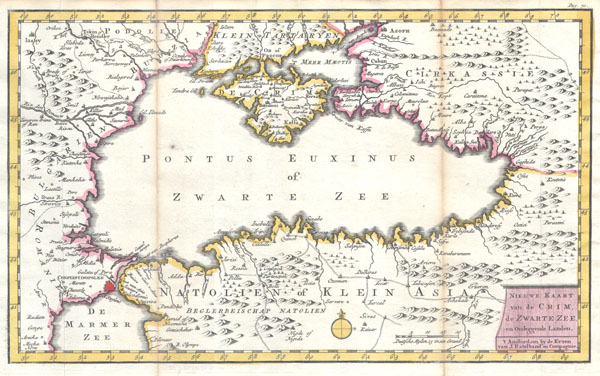
Nieuwe Kaart van de Crim de Zwarte Zee en Omleggende Landen.
c. 1747 (undated) 7.5 x 12 in (19.05 x 30.48 cm)
c. 1747 (undated) 7.5 x 12 in (19.05 x 30.48 cm)
Description
This is an extremely scarce 1747 Ratelband map of the the Black Sea. Details the Black Sea (Pontus Euxinus) and its immediate vicinity, including Crimea, Istanbul (Constantinople), northern Turkey, Circassia, parts of Armenia, and parts of Bulgaria and parts of Rumania. Set above a beautiful view of the strait showing the Rock of Gibraltar, the Barbary Coast and 16 sailing ships. Set within the frame of a decorative pink tapestry. Based upon the earlier charts prepared by Daniel de la Feuille. Prepared by an unknown engraver for inclusion as plate no. 30 in the 1747 issue of Ratelband's 'Geographisch-Toneel.'
Cartographer
Johannes Ratelband (1715 - 1793) was a European map publisher based in Amsterdam. Ratelband is a rather obscure fellow, but is known to have published a series of European maps and views in association with the La Feuille family. More by this mapmaker...
Source
Geographisch-Toneel, 1847 Ratelband issue.
Condition
Very good condition. Discoloration along original fold lines.