This item has been sold, but you can get on the Waitlist to be notified if another example becomes available, or purchase a digital scan.
1862 Torre / Colton Wall Map of Cuba
Cuba-torrecolton-1862$3,250.00

Title
Mapa Físico Político é Itinerario de la Isla De Cuba Acompañado de varios lanos particulares y de noticias estadisticas por D. Jose Maria de la Torre…
1862 (dated) 55.5 x 77.5 in (140.97 x 196.85 cm) 1 : 200000
1862 (dated) 55.5 x 77.5 in (140.97 x 196.85 cm) 1 : 200000
Description
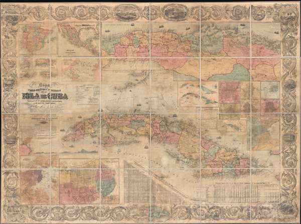
A wonderful 1862 wall map of Cuba by the Cuban historian José María de la Torre y de la Torre and the American map publisher Joseph H. Colton. The map covers all of Cuba and the surrounding waters with several massive insets, including a detail of the Havana region and insets of Mexico, Spain, the Atlantic, Puerto Rico, and other Caribbean islands. Inset plans of Cuban cities include Puerto de Habana, Plano de la Habana, Matanzas, Cienfuegos, Trinidad, Santiago de Cuba, Santa Maria del Puerto del Principe, Cardenas, and Guanabacoa.
This collaborative project brought together the best of Cuban and American cartographic publication in the form of Torre's mapmaking skills and Colton's masterful engraving and publishing abilities. Cartographically Torre derived the map from multiple sources including Francisco Coello de Portugal y Quesada's map of 1859 and Spanish Direccion Hidrografía maps. Stylistically the map is typical of Colton's early large-format separate-issue map work, comparable to his map of 1859 map of Bolivia and his 1836 map of New York. It bear's Colton's distinctive acanthus leave border work with inset vignettes of the Cuban countryside.
There are two known editions of this map, 1861 and 1862. This map is rare. We are aware of only 4 other examples, one in the Library of Congress (1861 edition), another in the British Library (1861), a third in the National Library of Spain (1862), and final example (1862) in private hands.
CartographerS
Joseph Hutchins Colton (July 5, 1800 - July 29, 1893), often publishing as J. H. Colton, was an important American map and atlas publisher active from 1833 to 1897. Colton's firm arose from humble beginnings when he moved to New York in 1831 and befriended the established engraver, Samuel Stiles. He worked under Stiles as the 'Co.' in Stiles and Co. from 1833 to 1836. Colton quickly recognized an emerging market in railroad maps and immigrant guides. Not a cartographer or engraver himself, Colton's initial business practice mostly involved purchasing the copyrights of other cartographers, most notably David H. Burr, and reissuing them with updated engraving and border work. His first maps, produced in 1833, were based on earlier Burr maps and depicted New York State and New York City. Between 1833 and 1855, Colton proceeded to publish a large corpus of guidebooks and railroad maps, which proved popular. In the early 1850s, Colton brought his two sons, George Woolworth Colton (1827 - 1901) and Charles B. Colton (1832 - 1916), into the map business. G. W. Colton, trained as a cartographer and engraver, was particularly inspired by the idea of creating a large and detailed world atlas to compete with established European firms for the U.S. market. In 1855, G.W. Colton issued volume one of the impressive two-volume Colton's Atlas of the World. Volume two followed a year later. Possibly because of the expense of purchasing a two-volume atlas set, the sales of the Atlas of the World did not meet Colton's expectations, and so, in 1856, the firm also issued the atlas as a single volume. The maps contained in this superb work were all original engravings, and most bear an 1855 copyright. All of the maps were surrounded by an attractive spiral motif border that would become a hallmark of Colton's atlas maps well into the 1880s. In 1857, the slightly smaller Colton's General Atlas replaced the Atlas of the World. Most early editions of the General Atlas published from 1857 to 1859 do not have the trademark Colton spiral border, which was removed to allow the maps to fit into a smaller format volume. Their customers must have missed the border because it was reinstated in 1860 and remained in all subsequent publications of the atlas. There were also darker times ahead; in 1858, Colton was commissioned at a sum of 25,000 USD by the government of Bolivia to produce and deliver 10,000 copies of a large format map of that country. Although Colton completed the contract in good faith, delivering the maps at his own expense, he was never paid by Bolivia, which was at the time in the midst of a series of national revolutions. Colton would spend the remainder of his days fighting with the Bolivian and Peruvian governments over this payment, and in the end, after a congressional intervention, he received as much as 100,000 USD in compensation. Nonetheless, at the time, it was a disastrous blow. J. H. Colton and Company is listed as one of New York's failed companies in the postal record of 1859. This led Colton into the arms of Alvin Jewett Johnson and Ross C. Browning. The 1859 edition of Colton's General Atlas lists Johnson and Browning as the 'Successor's to J. H. Colton' suggesting an outright buyout, but given that both companies continued to publish separately, the reality is likely more complex. Whatever the case may have been, this arrangement gave Johnson and Browning access to many of Colton's map plates and gave birth to Johnson's New Illustrated (Steel Plate) Family Atlas. The Johnson's Atlas was published parallel to Colton's atlases well into the 1880s. The Colton firm itself subsequently published several other atlases including an Atlas of America, the Illustrated Cabinet Atlas, the Octavo Atlas of the Union, and Colton's Quarto Atlas of the World. They also published a large corpus of wall maps, pocket maps, and guides. The last known publications of the Colton firm date to 1897 and include a map and a view, both issued in association with the Merchant's Association of New York. Alice M. Colton married August R. Ohman (May 3, 1859 - April 22, 1934) on January 5, 1897. In 1898, Ohman joined the Colton firm, which continued to publish as Colton, Ohman & Co. until 1901. More by this mapmaker...
José María de la Torre y de la Torre (September 1, 1815 – December 23, 1873) was a highly respected Cuban geographer, archeologist, historian and pedagogue. Torre was born in Havana and proved precocious as a child, graduating with a degree in jurisprudence and law at just 17. From as young 12, he worked with his uncle, Antonio María de la Torre, organizing and researching historical maps and documents relating to Cuban history. His first published map, Mapa Antiguo de la Isla de Cuba issued in 1833 when he was just 18, was a historical map of Cuba illustrating not only the European experience in Cuba, but also indigenous civilizations on the island at the time of Columbus. He worked with numerous Cuban newspaper and published works on history, archeology and geography. In 1848, the Cuban government sent him to the United States and Europe to study technological and agricultural advances that could be introduced to Cuba. There he joined the Royal Academy of History in Madrid and the Geographical Society of Paris, as well as other antiquarian and scientific learned societies. Torre died at sea in 1873. Learn More...
Condition
Good. Soiling and minor discoloration. Paper degradation. Professionally stabilized and laid down on fresh linen.
References
OCLC 431560080. Phillips (Cuba) p. 45.