
This item below is out of stock, but another example (left) is available. To view the available item, click "Details."
Details
1898 Colton Ohman Map of Cuba and Environs, Spanish-American War
$500.00
1898 Colton Ohman Map of Cuba and Environs, Spanish-American War
CubaFloridaSAWar-coltonohman-1898$250.00

Title
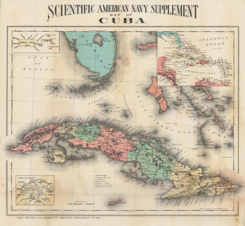
Scientific American Navy Supplement map of Cuba.
1898 (dated) 14.75 x 16 in (37.465 x 40.64 cm) 1 : 3000000
1898 (dated) 14.75 x 16 in (37.465 x 40.64 cm) 1 : 3000000
Description
A colorful representation of the Caribbean and South Florida focused on Cuba produced in for the Scientific American Navy Supplement. It was produced during the Spanish-American War and was distributed to help readers understand the geography of the conflict.
A Closer Look
Cuba is displayed divided into its provinces, which are color-shaded for easy distinction. Major cities and junctions are circled and shaded differently than their surrounding province for contrast. Railways are noted in detail, including a military railroad running north-south in the center of the island (Trocha de Júcaro a Morón), along with roads, rivers, mountains, and the dividing lines between dioceses. Florida, the Bahamas, and other surrounding islands and features are depicted. Three insets appear, one each focusing on Puerto Rico and Havana, with the inset at top-right providing a wider view of the Caribbean.The Spanish-American War
The Spanish-American War was fought between Spain and the United States between April 21, 1898, and August 13, 1898. The war started after the USS Maine suffered a massive explosion and sank in Havana Harbor. Tensions had been rising between the two countries for some time, with the U.S. showing support for Cuban independence while Spain claimed Cuba to be a province of Spain. The Spanish were quickly outgunned and outnumbered by the U.S. forces and surrendered after minimal conflict. After the fighting ended, the U.S. received the Philippines, Guam, and Puerto Rico along with Cuba as a U.S. protectorate.Publication History and Census
This map appeared in the Scientific American Navy Supplement No. 1165 in 1898. It was produced by Colton, Ohman, and Co., descendant of the firm founded by the great 19th century map publisher Joseph Hutchins Colton. The map is noted in OCLC as among the holdings of twelve institutions worldwide.CartographerS
August Reinhold Ohman (May 3, 1859 - April 22, 1934) was a Swedish-American map publisher, engraver, and draftsman. Ohman arrived in the United States in 1893. He married Alice Mary Colton (1868 - 193x), Charles B. Colton's daughter, on January 5, 1897. A year later, in 1898, Ohman began working with G.W. and C.B. Colton, when the firm became known as Colton, Ohman, and Company, which existed until about 1901. After that year, Ohman operated his own firm under his own name August R. Ohman, and advertised his firm as the 'successors to the Coltons'. The Ohman Map Company, as it became known, moved to 258 Broadway around 1914, where it operated until around 1925. George J. Nostrand, who became a major map publisher, operated in the same buiding and possibly even worked for Ohman. Some of Nostrand's work is very similar to Ohman's, particularly his bird's eye view of New York City. More by this mapmaker...
Joseph Hutchins Colton (July 5, 1800 - July 29, 1893), often publishing as J. H. Colton, was an important American map and atlas publisher active from 1833 to 1897. Colton's firm arose from humble beginnings when he moved to New York in 1831 and befriended the established engraver, Samuel Stiles. He worked under Stiles as the 'Co.' in Stiles and Co. from 1833 to 1836. Colton quickly recognized an emerging market in railroad maps and immigrant guides. Not a cartographer or engraver himself, Colton's initial business practice mostly involved purchasing the copyrights of other cartographers, most notably David H. Burr, and reissuing them with updated engraving and border work. His first maps, produced in 1833, were based on earlier Burr maps and depicted New York State and New York City. Between 1833 and 1855, Colton proceeded to publish a large corpus of guidebooks and railroad maps, which proved popular. In the early 1850s, Colton brought his two sons, George Woolworth Colton (1827 - 1901) and Charles B. Colton (1832 - 1916), into the map business. G. W. Colton, trained as a cartographer and engraver, was particularly inspired by the idea of creating a large and detailed world atlas to compete with established European firms for the U.S. market. In 1855, G.W. Colton issued volume one of the impressive two-volume Colton's Atlas of the World. Volume two followed a year later. Possibly because of the expense of purchasing a two-volume atlas set, the sales of the Atlas of the World did not meet Colton's expectations, and so, in 1856, the firm also issued the atlas as a single volume. The maps contained in this superb work were all original engravings, and most bear an 1855 copyright. All of the maps were surrounded by an attractive spiral motif border that would become a hallmark of Colton's atlas maps well into the 1880s. In 1857, the slightly smaller Colton's General Atlas replaced the Atlas of the World. Most early editions of the General Atlas published from 1857 to 1859 do not have the trademark Colton spiral border, which was removed to allow the maps to fit into a smaller format volume. Their customers must have missed the border because it was reinstated in 1860 and remained in all subsequent publications of the atlas. There were also darker times ahead; in 1858, Colton was commissioned at a sum of 25,000 USD by the government of Bolivia to produce and deliver 10,000 copies of a large format map of that country. Although Colton completed the contract in good faith, delivering the maps at his own expense, he was never paid by Bolivia, which was at the time in the midst of a series of national revolutions. Colton would spend the remainder of his days fighting with the Bolivian and Peruvian governments over this payment, and in the end, after a congressional intervention, he received as much as 100,000 USD in compensation. Nonetheless, at the time, it was a disastrous blow. J. H. Colton and Company is listed as one of New York's failed companies in the postal record of 1859. This led Colton into the arms of Alvin Jewett Johnson and Ross C. Browning. The 1859 edition of Colton's General Atlas lists Johnson and Browning as the 'Successor's to J. H. Colton' suggesting an outright buyout, but given that both companies continued to publish separately, the reality is likely more complex. Whatever the case may have been, this arrangement gave Johnson and Browning access to many of Colton's map plates and gave birth to Johnson's New Illustrated (Steel Plate) Family Atlas. The Johnson's Atlas was published parallel to Colton's atlases well into the 1880s. The Colton firm itself subsequently published several other atlases including an Atlas of America, the Illustrated Cabinet Atlas, the Octavo Atlas of the Union, and Colton's Quarto Atlas of the World. They also published a large corpus of wall maps, pocket maps, and guides. The last known publications of the Colton firm date to 1897 and include a map and a view, both issued in association with the Merchant's Association of New York. Alice M. Colton married August R. Ohman (May 3, 1859 - April 22, 1934) on January 5, 1897. In 1898, Ohman joined the Colton firm, which continued to publish as Colton, Ohman & Co. until 1901. Learn More...
Source
Scientific American special naval supplement : with map of Cuba, (Navy edition of the Scientific American supplement, no. 1165), (New York: Munn and Co.) 1898.
Condition
Good. Some discoloration.
References
OCLC 29892828, 84156713.