This item has been sold, but you can get on the Waitlist to be notified if another example becomes available, or purchase a digital scan.
1898 Johnston Map of Cuba and the Caribbean, Spanish-American War
CubaQuestion-johnston-1898$750.00

Title
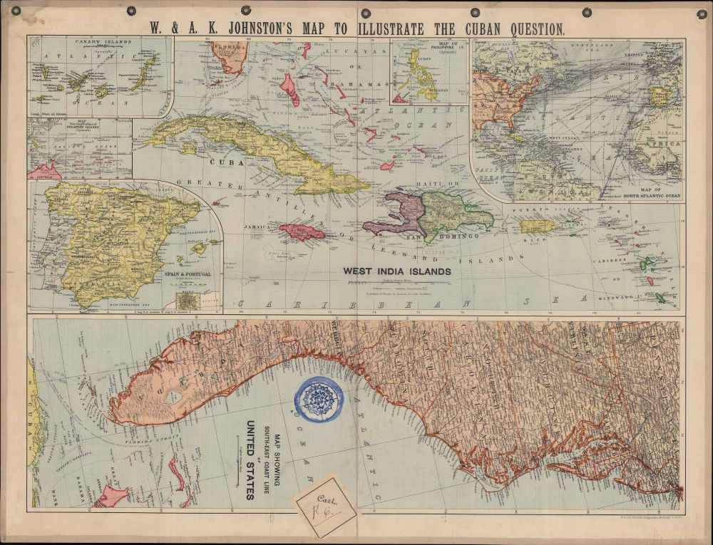
W. and A.K. Johnston's Map to illustrate the Cuban question.
1898 (undated) 17 x 21 in (43.18 x 53.34 cm)
1898 (undated) 17 x 21 in (43.18 x 53.34 cm)
Description
A series of maps related to the Spanish-American War, this sheet was published by W. and A.K. Johnston in 1898 to illustrate the theater of conflict and related territories. It was produced in the wake of the USS Maine explosion and rising tensions between the U.S. and Spain.
A Closer Look
The sheet is roughly divided in half, with the lower half being a map of the coastline of the southeastern United States and the top half focusing on Cuba and the Caribbean (West India Islands). The top half includes five inset maps, which are, clockwise from the top: the Philippine Islands, a map of the North Atlantic Ocean focusing on shipping lines, a map of Spain and Portugal (itself with an inset of Madrid), a map of the southwestern Pacific Ocean, and a map of the Canary Islands. Cities, railways, telegraph lines, rivers, mountains, shoals, and ocean currents are indicated throughout. Color-coded shading is used to distinguish different countries and their colonial possessions.The Spanish-American War
The Spanish-American War was fought between Spain and the United States between April 21, 1898, and August 13, 1898. The war started after the USS Maine suffered a massive explosion and sank in Havana Harbor, though it remains unclear if the cause was a Spanish mine or an accidental fire on board. Tensions had been rising between the two countries for some time, with the U.S. showing support for Cuban independence while Spain claimed Cuba to be a province of Spain. The Spanish were quickly outgunned by U.S. forces, while also combatting disease and local insurgents, and surrendered after minimal conflict. After the fighting ended, the U.S. received the Philippines, Guam, and Puerto Rico along with Cuba as a U.S. protectorate. Though much of the tension leading to the war was centered on Cuba, perhaps the most significant outcome of the conflict was America's emergence as a 'Pacific power.'Publication History and Census
This sheet was lithographed and published by W. and A.K. Johnston in 1898. It is held by the Huntington Library, the Boston Public Library, and the National Library of Scotland, and has no known history on the market. The examples of this map in institutional collections look to be folding maps, whereas this is mounted on linen and outfitted with grommets for hanging, making it perhaps a unique presentation of this map.Cartographer
Alexander Keith Johnston (December 28, 1804 - July 9, 1871) was a Scottish cartographer and map publisher active in the middle portion of the 19th century. Johnson was born at Kirkhill, near Edinburgh, Scotland. He studied at the University of Edinburgh where he apprenticed as an engraver. Around 1826, in partnership with his brother William, he founded a cartographic printing and engraving firm with the imprint "W. and A. K. Johnston." Johnston made a name for himself in educational geography, publishing numerous maps for use in schools. His brother, William Johnston, eventually left the firm to pursue a career in politics, eventually becoming the Lord Provost of Edinburgh. Alexander's son, who would bear the same name, became a geographer and explorer, suffering an untimely death on the Royal Geographical Society's 1879 expedition to Lake Nyasa. More by this mapmaker...
Condition
Very good. Mounted on linen.
References
OCLC 316615096, 83446810.