1863 Admiralty Nautical Chart of the Gujarati Coast and Mumbai (Bombay)
CutchViziadrug-admiralty-1863$550.00


Title
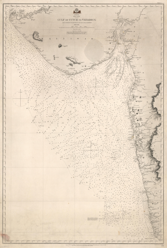
India. West Coast. Gulf of Cutch to Viziadrug.
1863 (dated) 39.25 x 26 in (99.695 x 66.04 cm) 1 : 840000
1863 (dated) 39.25 x 26 in (99.695 x 66.04 cm) 1 : 840000
Description
This is an 1863 British Admiralty nautical chart or maritime map of the Gujarati coast and the coast of Maharashtra including Mumbai / Bombay.
A Closer Look
Depicting from the Gulf of Kutch to Vengurla (Vingorla) and from the Arabian Sea to the Western Ghats, depth soundings (fathoms) are indicated up to the continental shelf. Significant coastal detail is provided, with towns, cities, forts, lakes, rivers, and other landmarks identified. Elevations for mountains and hills within sight of the coastline are also noted, allowing mariners to better situate themselves. Mumbai (Bombay), Khambhat (Cambay) and Vijaydurg (Viziadrug) are among the labeled coastal cities. The Bombay and Baroda Railway, the Railway to Nagpur, and the Railway to Punnah are also labeled.Publication History and Census
This map was published by the British Admiralty under the Superintendence of John Washington in 1863. We note only one holding, at the British Library.CartographerS
The British Admiralty Office (1795 - Present) or the United Kingdom Hydrographic Office refers to the Branch of the English government that is responsible for the command of the British Navy. In 1795 King George III created the United Kingdom Hydrographic Office, known in short as the U.K.H.O., to provide top notch nautical charts to the vast Royal Navy. Prior the founding of the Admiralty the surveying and creation of nautical charts was primarily a commercial venture wherein the cartographer himself, more of than not, actually financed the printing of his own material. The great navigator Cook himself is known to have scrambled for funds to publish his own seminal charts - the most important and advanced of the period. The system of privately funded nautical mapping and publishing left vast portions of the world uncharted and many excellent charts unpublished. King George III, responding significant loss in trade revenue related to shipwrecks and delay due to poor charts, recognized the need for an institutionalized government sponsored cartographic agency - the Admiralty. The first head of the Admiralty, a position known as Hydrographer, was the important cartographer Alexander Dalrymple. Dalrymple started by organizing and cataloging obtainable charts before initiating the laborious process of updating them and filling in the blanks. The first official Admiralty Chart appeared in 1800 and detailed Quiberon Bay in Brittany. By 1808 the position of Hydrographer fell to Captain Thomas Hurd. Hurd advocated the sale of Admiralty charts to the general public and, by the time he retired in 1829, had issued and published some 736 charts. Stewardship of the organization then passed to Rear Admiral Sir Francis Beaufort. It was under Beaufort's administration that the Admiralty truly developed as a "chart making" as opposed to a "chart cataloging" institution. Beaufort held his post from 1829 to 1854. In his 25 years at the Admiralty Beaufort created nearly 1500 new charts and sponsored countless surveying and scientific expeditions - including the 1831 to 1836 voyage of the H.M.S. Beagle. By 1855 the Admiralty's chart catalog listed some 1,981 charts. More by this mapmaker...
John Washington (1800 - September 16, 1863) was a hydrographer, Royal Navy officer, and founding member of the Geographical Society of London. In May 1812, Washington joined the Royal Navy and in November 1814 entered the Royal Naval Academy. He graduated from the Academy in May 1816 and on January 1, 1821 was promoted to lieutenant. He was one of the original members of the Royal Geographical Society and from 1836 until 1841 served as its secretary. He gained the rank of captain on March 16, 1842. Over the course of his career, Washington served on nearly one dozen different Royal Navy vessels. He became Hydrographer of the Navy following the resignation of Sir Francis Beaufort in 1855. He died at Le Havre on September 16, 1863. Learn More...
Condition
Very good. Even overall toning. Closed margin tears professionally repaired on verso.
References
OCLC 557746061.