
This item below is out of stock, but another example (left) is available. To view the available item, click "Details."
Details
1944 Turner Map of the World During World War II
1944 (dated) $300.00
1945 Turner Map of the World at the End of World War II
DatedEvents28thEdition-turner-1945-2$150.00

Title
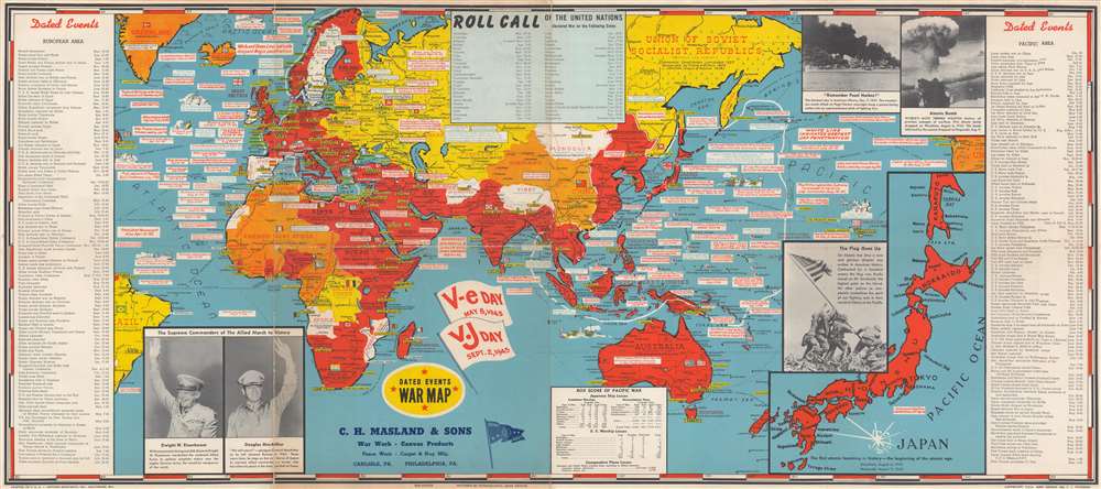
Dated Events War Map.
1945 (dated) 17.25 x 38.75 in (43.815 x 98.425 cm) 1 : 42500000
1945 (dated) 17.25 x 38.75 in (43.815 x 98.425 cm) 1 : 42500000
Description
This is a 1945 Stanley Francis Turner map of the world at the end of World War II. The map depicts the world from St. John's in Newfoundland, Canada to Salt Lake City, Utah and from the Barents Sea and the Arctic Ocean to Macquarie Island in the southwest Pacific Ocean. Myriad events throughout the European, North African, and Pacific Theaters of War are identified, including numerous declarations of war, the Japanese attack on Pearl Harbor, the D-Day Invasion of France, the liberation of Rome and Paris, and nearly all the amphibious landings in the Pacific island-hopping campaign. Rommel's retreat from Egypt through Libya into Tunisia is noted by a white line, while solid white lines in Europe, Africa, and the Pacific illustrate the greatest extent of Axis gains.
Two large flags, just below center, commemorate and celebrate V-E (Victory in Europe) Day, May 8, 1945, and V-J (Victory over Japan) Day, September 2, 1945. Events in the European Theater are chronicled along the map's left border, from the Munich Agreement on September 30, 1938 to Clement Attlee's inauguration as Prime Minister, replacing Winston Churchill. Events during the Pacific War are listed along the right border, from the beginning of the Shanghai Incident between China and Japan in January 1932 to V-J Day. A 'box score of the Pacific War', situated along the bottom border, lists the number of ships lost by both the Japanese and the U.S. during the course of the war, along with the comparative losses of the number of airplanes. A large inset map of Japan is located in the lower right corner, while photographs of the Pearl Harbor attack and one of the mushroom clouds from the atomic bombs dropped on Japan occupy the upper right corner. Photographs of General Eisenhower and General MacArthur are included in the lower left corner.
Two large flags, just below center, commemorate and celebrate V-E (Victory in Europe) Day, May 8, 1945, and V-J (Victory over Japan) Day, September 2, 1945. Events in the European Theater are chronicled along the map's left border, from the Munich Agreement on September 30, 1938 to Clement Attlee's inauguration as Prime Minister, replacing Winston Churchill. Events during the Pacific War are listed along the right border, from the beginning of the Shanghai Incident between China and Japan in January 1932 to V-J Day. A 'box score of the Pacific War', situated along the bottom border, lists the number of ships lost by both the Japanese and the U.S. during the course of the war, along with the comparative losses of the number of airplanes. A large inset map of Japan is located in the lower right corner, while photographs of the Pearl Harbor attack and one of the mushroom clouds from the atomic bombs dropped on Japan occupy the upper right corner. Photographs of General Eisenhower and General MacArthur are included in the lower left corner.
A Closer Look at the Map
Capitals and other cities throughout the world are labeled, with the capitals of important belligerents, such as Paris, Vichy, London, Berlin, and Tokyo, written in bold. Countries are labeled and shaded varying colors, signifying their status as having been liberated by the Allies, originally one of the Allies, neutral nations, and the Soviet Union. Surprisingly, Brazil is also yellow, even though it was not directly associate with the Soviet Union during the war. The United States, China, French West Africa, Iceland, and Greenland are shaded orange, potentially because they joined the Allied cause after the beginning of the war.Publication HistoryThis map was created by Stanley Turner and published by C.C. Peterson. C.C. Peterson never updated their copyright on Turner's maps, thus the date remains 1942 for all editions of the Dated War Maps of this design. This is the 28th edition of the Dated Events War Map and this particular example was promotes C.H. Masland and Sons, carpet and rug manufacturers from Carlisle and Philadelphia, Pennsylvania.
CartographerS
Stanley Francis Turner (1883 – 1953) was a visual artist and painter based in Toronto, Canada. Turner was born in Aylesbury, England. He studied art in London at the South Kensington School before migrating to Canada in 1903, where he studied at Ontario College of Art under George Reid and J. W. Beatty. Turner is best known as a painter and designer capable of working in a variety of mediums. During World War II, Turner took a contract with the Globe and Mail to illustrate pictorial maps of war events. Turner may have maintained the rights to his war maps, as he also seems to have had a contract with the advertiser and publisher, C.C. Peterson, also of Toronto, to publish and distribute his maps in the United States. Turner's maps are information dense and designed to illustrate the events of the war in an easily digestible pictorial format. Turner experimented with different ways of working with the cartographic ranging from simple Mercator projections to more contemporary equal-area projections. In 1930, Turner was elected an Associate of the Royal Canadian Academy of Arts. He died in Toronto in 1953. More by this mapmaker...
C. C. Peterson (fl. c. 1940 – 1950) was an advertising and publishing company based in Toronto Canada, but with distribution and licensing in both the United States and Canada. Peterson had contracts with the artist Stanley Francis Turner to publish pictorial 'war maps' during World War II. The company supplemented its income by selling advertisements on Turner's maps. Learn More...
Condition
Very good. Closed margin tears professionally repaired on verso. Verso repairs to fold separations. Exhibits some slight loss at fold intersections. Exhibits some wear along original fold lines.