1944 Turner Map of the World During World War II
DatedWarMap17thEd-turner-1944$300.00


Title
Dated Events War Map.
1944 (dated) 17 x 28.5 in (43.18 x 72.39 cm) 1 : 32000000
1944 (dated) 17 x 28.5 in (43.18 x 72.39 cm) 1 : 32000000
Description
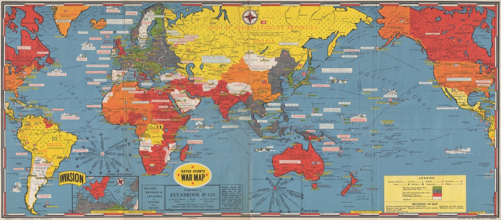
This is a 1944 Stanley Francis Turner world map detailing the events of World War II until mid-1944. This map, part of a series encompassing more than 25 editions, was meticulously and regularly updated, allowing the home front to digest the complex tides of war.
Myriad small text boxes appear throughout the map, each bearing a bit of information about the progress of the war. Some recount Allied defeats, such as the fall of France. Others commemorate Allied victories, such as the back and forth of the North African campaign, and the Allied invasions of Sicily and Italy. Diplomatic benchmarks are included as well, such as the Casablanca conference, the signing of the Atlantic Charter between Roosevelt and Churchill, and the Lend-Lease Act. The date that a certain country joined the Allied cause is also reported for numerous countries around the world.
A Closer Look
The map depicts the world from the Atlantic coast of North America and the whole of South America across Europe, Africa, Asia and the Pacific Ocean to the North American coast and the Pacific coast of South America. Combatants are illustrated by color: green for the Axis powers: Germany, Italy, and Japan.; Red for the United Kingdom and the British Empire; the United States is orange. Countries that became allies of the Allied Powers over the course of the war are shaded yellow, including the Soviet Union, as they did not join the Allied cause until after Nazi Germany invaded the Soviet Union on June 22, 1941 (Operation Barbarossa). Land conquered by the Axis is shaded gray, including both Occupied and Vichy France, most of Eastern Europe, and a significant amount of the territory conquered by Japan in the Pacific. The American Pacific War had not made significant gains by June 1944, but areas reconquered by the Americans in the Pacific and the Allies in North Africa and Europe are shaded red, such as the Solomon and Marshall Islands. By mid-1944, the Allies had reconquered all North Africa and had faced brutal fighting in southern Italy. Rome would not be liberated until June 4, 1944.Myriad small text boxes appear throughout the map, each bearing a bit of information about the progress of the war. Some recount Allied defeats, such as the fall of France. Others commemorate Allied victories, such as the back and forth of the North African campaign, and the Allied invasions of Sicily and Italy. Diplomatic benchmarks are included as well, such as the Casablanca conference, the signing of the Atlantic Charter between Roosevelt and Churchill, and the Lend-Lease Act. The date that a certain country joined the Allied cause is also reported for numerous countries around the world.
A Coming Invasion?
An inset map along the bottom border details possible locations for the presumed Allied invasion of France. Distances between different points along the English coast and the French coast are given. Countries that remained occupied by the Nazis are labeled as such: Nazi Occupied France and Nazi Occupied Denmark are two good examples. A big yellow arrow proclaims the INVASION in block lettering. Just above the inset map is a sort of inverted compass, entitled 'Closing In On Berlin', detailing the distances aerial bombing missions had to travel from European capitals to reach Berlin. The same sort of inverted compass is included along the bottom border giving distances from various locations around the Pacific theater to Tokyo.More Details
World capitals are labeled throughout the map, along with numerous other cities in countries the world over. The flags of the nations of the world are also depicted, including the American flag, the Union Jack, and the flags of Imperial Japan and Nazi Germany. Ships, some of which are illustrated with the camouflage paint schemes that were popular during World War I and World War II, are depicted throughout the world’s oceans. A legend explaining the different colors and symbols employed on the map appears in the lower right. A decal stating that this particular example of this map was furnished compliments of Estabrook and Company is situated along the bottom border near center.Publication History and Census
This map was drawn by Stanley Francis Turner and published by C. C. Peterson. This is the 17th edition of the Dated War Map. We are aware of 25 different editions, although there may be more. Each example that we have seen also was furnished by a different company, thus giving each example a different look. An example of the 17th edition of the Dated Events War Map (with a different advertiser) is part of the David Rumsey Map Collection.Cartographer
Stanley Francis Turner (1883 – 1953) was a visual artist and painter based in Toronto, Canada. Turner was born in Aylesbury, England. He studied art in London at the South Kensington School before migrating to Canada in 1903, where he studied at Ontario College of Art under George Reid and J. W. Beatty. Turner is best known as a painter and designer capable of working in a variety of mediums. During World War II, Turner took a contract with the Globe and Mail to illustrate pictorial maps of war events. Turner may have maintained the rights to his war maps, as he also seems to have had a contract with the advertiser and publisher, C.C. Peterson, also of Toronto, to publish and distribute his maps in the United States. Turner's maps are information dense and designed to illustrate the events of the war in an easily digestible pictorial format. Turner experimented with different ways of working with the cartographic ranging from simple Mercator projections to more contemporary equal-area projections. In 1930, Turner was elected an Associate of the Royal Canadian Academy of Arts. He died in Toronto in 1953. More by this mapmaker...
Condition
Very good. Old verso repairs along original fold lines.
References
Rumsey 15498.000.