This item has been sold, but you can get on the Waitlist to be notified if another example becomes available, or purchase a digital scan.
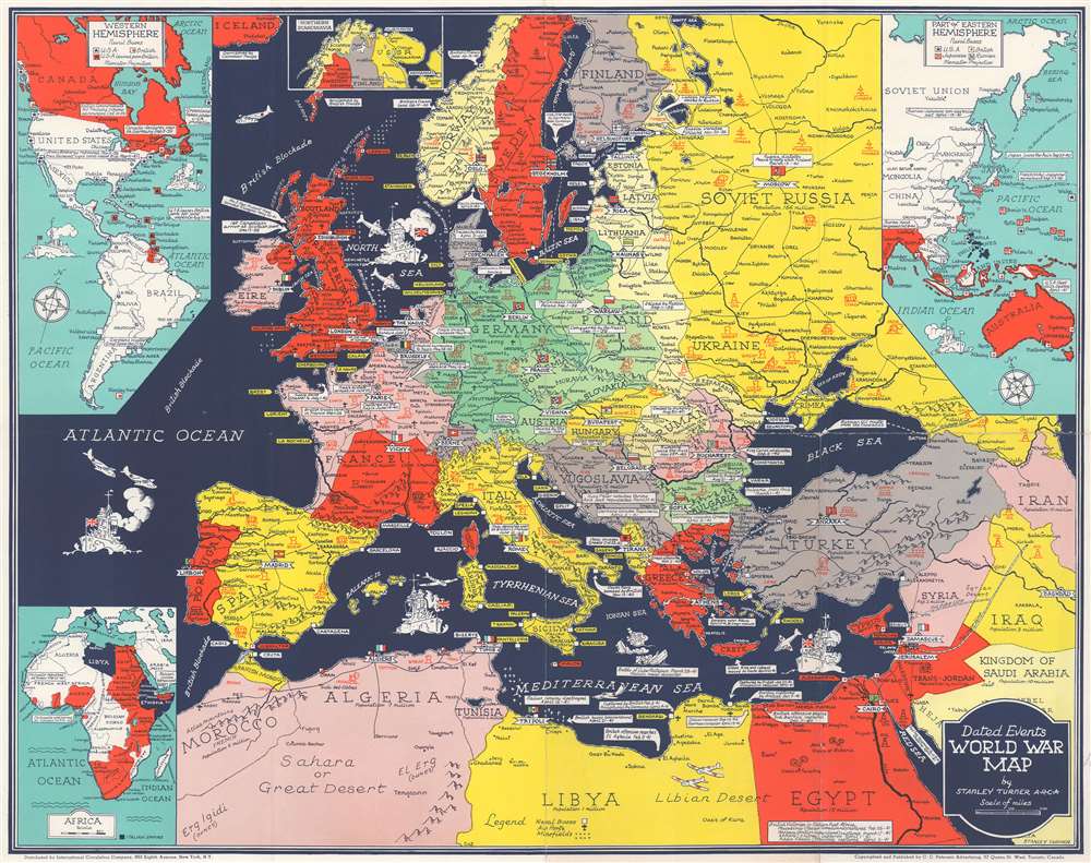
1941 Turner Map of Europe During World War II - his first map!
DatedEventsWarMap-turner-1941$250.00

Title
Dated Events World War Map.
1941 (undated) 16.75 x 21.25 in (42.545 x 53.975 cm) 1 : 10137600
1941 (undated) 16.75 x 21.25 in (42.545 x 53.975 cm) 1 : 10137600
Description
This is a 1941 Stanley Francis Turner map of Europe during World War II (1939 - 1945), likely Turner's first 'Dated Events' map. This map was issued in late May or early June, based on the events noted. Text boxes mark events, including combat actions and declarations of war, beginning with the 1938 Anschluss. Icons illustrate areas rich in resources, including steel, wheat, coal, and iron - valuable to the war effort on both sides. France is divided into the Occupied Zone and the Unoccupied Zone.
Inset Maps
An inset in the upper left details American forces and marks American and British naval bases, also naming a handful of events. A second inset, along the top, illustrates Norway, Sweden, Finland, and the Soviet Union. The third inset in the top half of the map details East Asia and the Pacific, marking American, British, Japanese, and Russian naval bases as far east as Wake Island. Curiously, no mention of fighting in Asia is made. In the lower-left, a fourth inset details the situation in Africa and marks the failed Free French attack on Dakar and De Gaulle's successful arrival in Douala.Turner's First World War II Map?
Unlike nearly every other map Turner published, the coloring on this map is not coordinated. Here, the color is only used to distinguish between countries, not to align them with one side of the conflict or another. It appears that this is also Turner's only map where oceans are black. We have been unable to locate an earlier Turner map, suggesting that this is his first. His many subsequent maps, published throughout World War II, represent individually and in aggregate a unique cartographic history of the war.Publication History and Census
This map was drawn by Stanley Francis Turner and published by C.C. Petersen in 1941. We have been unable to locate any other examples of the present - making it also the rarest Turner map.CartographerS
Stanley Francis Turner (1883 – 1953) was a visual artist and painter based in Toronto, Canada. Turner was born in Aylesbury, England. He studied art in London at the South Kensington School before migrating to Canada in 1903, where he studied at Ontario College of Art under George Reid and J. W. Beatty. Turner is best known as a painter and designer capable of working in a variety of mediums. During World War II, Turner took a contract with the Globe and Mail to illustrate pictorial maps of war events. Turner may have maintained the rights to his war maps, as he also seems to have had a contract with the advertiser and publisher, C.C. Peterson, also of Toronto, to publish and distribute his maps in the United States. Turner's maps are information dense and designed to illustrate the events of the war in an easily digestible pictorial format. Turner experimented with different ways of working with the cartographic ranging from simple Mercator projections to more contemporary equal-area projections. In 1930, Turner was elected an Associate of the Royal Canadian Academy of Arts. He died in Toronto in 1953. More by this mapmaker...
C. C. Peterson (fl. c. 1940 – 1950) was an advertising and publishing company based in Toronto Canada, but with distribution and licensing in both the United States and Canada. Peterson had contracts with the artist Stanley Francis Turner to publish pictorial 'war maps' during World War II. The company supplemented its income by selling advertisements on Turner's maps. Learn More...
Condition
Very good. Exhibits wear along original fold lines. Verso repairs to fold separations and at fold intersections.