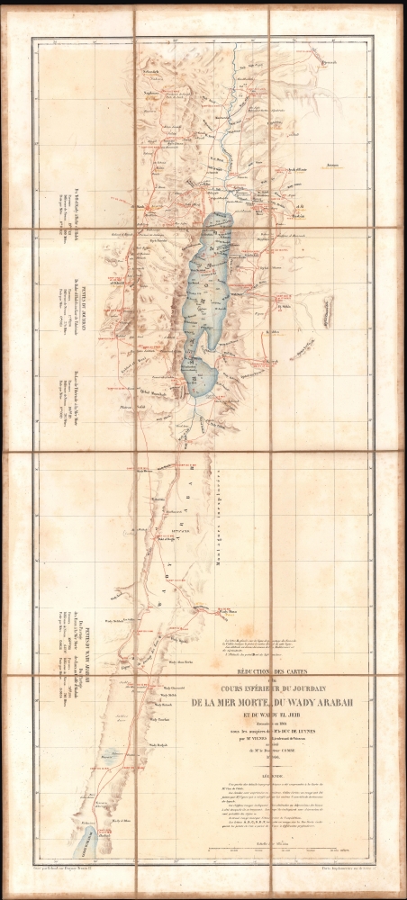
1866 Vignes / Lemercier Map of the Dead Sea and Environs, Holy Land
DeadSea-lemercier-1866$1,200.00

Title
Réduction des cartes du cours inférieur du Jourdain, de la mer Morte, du wady Arabah et du wady El Jeib.
1866 (dated) 27.5 x 11.25 in (69.85 x 28.575 cm) 1 : 480000
1866 (dated) 27.5 x 11.25 in (69.85 x 28.575 cm) 1 : 480000
Description
A scarce 1866 separate-issue folding map of the Dead Sea and the Jordan Rift Valley by Louis Vignes. It was the product of the Duc de Luynes's 1864 expedition to the Dead Sea, noted for its scientific discoveries, as well as the early photographs of the region taken by Vignes.
The locations of Jacob's Well and Joseph's Tomb are observed outside Naplouse (Nablus) near top-left. Jerusalem, here as el Kods (al-Quds), sits due west of the northernmost portion of the Dead Sea. Other ancient cities are similarly noted with their Arabic names predominating, as with er Riha (Ariha, Jericho) and el Kulil (al-Khalil, Hebron).
A Closer Look
Coverage extends from the Jordan River Valley roughly halfway between the Sea of Galilee and the Dead Sea down through the Dead Sea and to the Gulf of Akabah (Aqaba), which links to the Red Sea. The progress of the expedition is traced in red, including on the sea itself, with camp locations and dates indicated. Placenames are assiduously noted, along with explanations and tables on elevation (soundings on the sea).The locations of Jacob's Well and Joseph's Tomb are observed outside Naplouse (Nablus) near top-left. Jerusalem, here as el Kods (al-Quds), sits due west of the northernmost portion of the Dead Sea. Other ancient cities are similarly noted with their Arabic names predominating, as with er Riha (Ariha, Jericho) and el Kulil (al-Khalil, Hebron).
The Duc de Luynes's 1864 Expedition
The 1864 expedition led by Honoré Théodoric d'Albert de Luynes took place in the wake of the groundbreaking surveys of the Holy Land undertaken by the Dutch cartographer Charles William Meredith van de Velde in 1851, published in 1858. The Duc de Luynes was a wealthy nobleman and statesman who devoted most of his time to archaeological and numismatic research, initially in southern Italy and then more broadly around the Mediterranean. This led him to organize and finance an expedition to Palestine, the Dead Sea, and Petra, which, aside from its intended archaeological purposes, gained important insights on the mineralogy and geology of the Dead Sea region. However, it became best known for Vignes' photographs, which were among the earliest of the Dead Sea and Jordan.The Jordan Rift Valley and the Dead Sea
Aside from its historical importance for Abrahamic religions, the Jordan Rift Valley is also very significant in geological terms, as it reaches a deep depression, the lowest land elevation on Earth. As shown here, the shores of the Dead Sea sit at nearly 400 meters below sea level. The sea is also noted for its intense salinity, making it nearly impossible for animal or plant life to exist, the source of its name. This has led to remarkable and even unique deposits of minerals that have been prized since Antiquity. In recent years, the Dead Sea has seen significant recession as waters further north are diverted for civilian use; various proposals have been floated for replenishing the sea's waters, including a canal extending from the Gulf of Aqaba.Publication History and Census
This map was drawn by Louis Vignes with assistance from 'Dr. Combe,' another member of the expedition, in 1864 and then prepared for publication in 1866. Vignes and Combe also produced a second, smaller map titled 'Carte du cours inférieur du Jourdain de la Mer Morte.' However, the published account of the expedition, Voyage d'exploration à la Mer Morte, à Petra, et sur la rive gauche du Jourdain, did not appear until 1875, eight years after Luynes's death. Only one other example of this map is independently cataloged in the OCLC, at the Bibliothèque nationale de France, while the entire Voyage d'exploration is more widely distributed. However, the present example is dissected, laid on linen, and folds into an accompanying cover, indicating that it was issued separately from, and perhaps prior to, Voyage d'exploration.CartographerS
Louis Vignes (June 8, 1831 - July 1, 1896) was a French naval officer, photographer, and cartographer. After graduating from the École navale in 1846, he had risen to the rank of lieutenant by 1860. During these years, he took up an interest in photography as a hobby and became connected with pioneers in the field, such as the Société française de photographie. Taking photographs on postings around the Mediterranean, he earned a reputation within the navy as a skilled photographer. For this reason, he was asked to accompany Honoré Paul Joseph d'Albert, duc de Luynes on his first expedition to the Dead Sea region in 1863 - 1864. Afterwards, Vignes saw various postings around the world in the navy, eventually achieving the rank of vice admiral and becoming the Inspecteur général de la Marine. The photographs Vignes took during the duc de Luynes's expedition constitute some of the earliest of the region, and his use of glass negative plates produced especially good quality images for the time. More by this mapmaker...
Rose-Joseph Lemercier (June 29, 1803 - 1887) was a French photographer, lithographer, and printer. One of the most important Parisian lithographers of the 19th century, Lemercier was born in Paris into a family of seventeen children. His father was a basket maker, and he even began working as a basket maker at the age of fifteen, but Lemercier was drawn to lithography and printing and soon entered into an apprenticeship with Langlumé, where he worked from 1822 until 1825. After working for a handful of other printers, Lemercier started his own firm in 1828 at 2, rue Pierre Sarrazin with only one printing press. He subsequently moved a few more times before arriving at 57, rue de Seine, where he founded the printing firm Lemercier and Company. He created the firm Lemercier, Bénard and Company in 1837 with Jean François Bénard. Lemercier bought out Bénard's share in the firm in 1843 and, since his two sons died at a young age, he decided to bring his nephew Alfred into the business beginning in 1862, who would progressively take on more and more responsibility in running the firm. Between 1850 and 1870, Lemercier's firm was the largest lithographic company in Paris. The firm began to decline in prestige in the early 1870s, and, after Lemercier's death in 1887, its descent only quickened. It is unclear when the firm closed, but Alfred directed the firm until his death in 1901. Learn More...
Georges Erhard Schièble (1823 – November 23, 1880) was a German printer active in Paris during the middle to late 19th century. Erhard was born in Forchheim, Baden-Württemberg, and relocated to Paris in his 16th year, where he apprenticed under his cousin, an engraver and mapmaker. In 1852, after 6 years with the Royal Printing Office, he started his own business. Around this time, he also became a naturalized French citizen. From his offices on Rue Bonaparte, he produced several important maps, and a detailed topography of Gaul for Napoleon III's History of Julius Caesar. In 1865 he took on larger offices expanding his operations to include a lithographic press. He was among the first to introduce printed color maps and pioneered photo-reduction, including the process known as Erhard reproduction. After Erhard's death in 1880, the firm was taken over by his sons and run under the imprint of 'Erhard Frères' until 1911. Learn More...
Condition
Good. Foxing present throughout. Dissected and laid on linen. Folds into original cover.
References
OCLC 494974848.