This item has been sold, but you can get on the Waitlist to be notified if another example becomes available, or purchase a digital scan.
1761 Desnos / Mornas Diagram of Aerology / Meteorology
DeLAerologie-desnos-1761$150.00

Title
De L'Aerologie.
1761 (undated) 14.5 x 20.75 in (36.83 x 52.705 cm)
1761 (undated) 14.5 x 20.75 in (36.83 x 52.705 cm)
Description
This is a beautifully hand-colored example of Desnos and Mornas' curious c. 1761 sheet on 'Aerology' from their Atlas Méthodique et Elémentaire. A fascinating work of Enlightenment-era natural philosophy, it marks a stepping stone on the path towards modern atmospheric science.
Taken together, the sheet is a product of an intermediary stage between 'natural philosophy' and modern atmospheric science. Some of the terminology sounds antiquated, and some ideas proved to be inaccurate, but overall, there is an impressive understanding of the division of the atmosphere into distinct regions based on altitude, the varying density of air at different altitudes, the effects of air pressure, and the refraction of light in the atmosphere.
A Closer Look
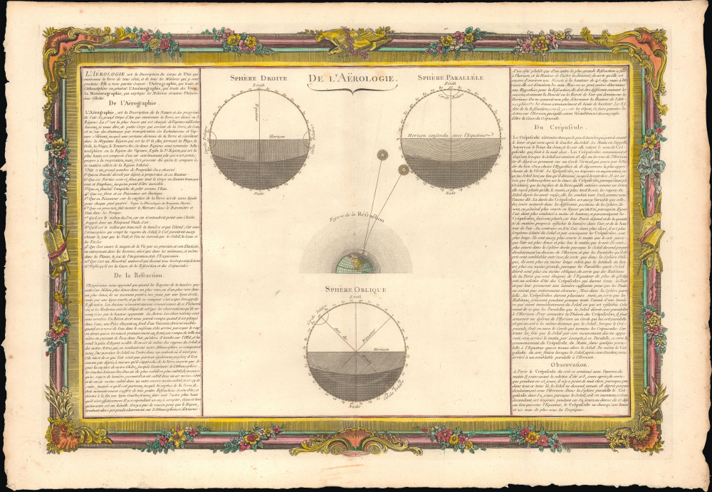
The sheet includes a central section with three circles, representing the Earth at an upright, right, and oblique angle, in each case with the poles, equator, and degrees noted. Lines representing the horizon and twilight ('crepuscule') are used to demonstrate the progression of sunlight, while a small globe at center demonstrates the principle of the refraction of the sun's light. Panels of text at left and right discuss the science of aerology, divided into aerography, anemography, and meteorography.Taken together, the sheet is a product of an intermediary stage between 'natural philosophy' and modern atmospheric science. Some of the terminology sounds antiquated, and some ideas proved to be inaccurate, but overall, there is an impressive understanding of the division of the atmosphere into distinct regions based on altitude, the varying density of air at different altitudes, the effects of air pressure, and the refraction of light in the atmosphere.
Publication History and Census
This sheet was issued in the 1761 edition of the Atlas General Methodique et Elementaire, pour l’Etude de la Geographie et de l’Histoire Moderne by Louis-Charles Desnos and Claude Buy du Mornas. This sheet is not independently cataloged in any institutional collections, while the entire atlas is well-represented.CartographerS
Louis Charles Desnos (1725 - April 18, 1805) was an important 18th century instrument maker, cartographer and globe maker based in Paris, France. Desnos was born in Pont-Sainte-Maxence, Oise, France, the son of a cloth merchant. From April of 1745 he apprenticed at a metal foundry. Desnos married the widow of Nicolas Hardy, sone of the map, globe, and instrument seller Jacques Hardy. Desnos held the coveted position of Royal Globemaker to the King of Denmark, Christian VII, for which he received a stipend of 500 Livres annually. In return Desnos sent the King roughly 200 Livres worth of maps, books and atlases each year. As a publisher, Desnos produced a substantial corpus of work and is often associated with Zannoni and Louis Brion de la Tour (1756-1823). Despite or perhaps because of the sheer quantity of maps Desnos published he acquired a poor reputation among serious cartographic experts, who considered him undiscerning and unscrupulous regarding what he would and would not publish. Desnos consequently had a long history of legal battles with other Parisian cartographers and publishers of the period. It is said that he published everything set before him without regard to accuracy, veracity, or copyright law. Desnos maintained offices on Rue St. Jacques, Paris. More by this mapmaker...
Claude Buy de Mornas (17xx - 1783) was a French geography professor. He published the Atlas Méthodique et Elémentaire de Géographie et d'Histoire jointly with Louis-Charles Desnos (1725 - 1805) in 1761. Desnos claimed the plates for the Atlas Méthodique after Buy de Mornas died. Learn More...
Source
Buy de Mornas, C. and L. C. Desnos, Atlas Méthodique et Elémentaire de Géographie et d'Histoire, (Paris: Mornas and Desnos) 1761.
Condition
Very good. Light wear along original centerfold.