This item has been sold, but you can get on the Waitlist to be notified if another example becomes available, or purchase a digital scan.
1785 Cook Map of Alaska and the Bering Strait
DetroitDeBhering-cook-1785$112.50

Title
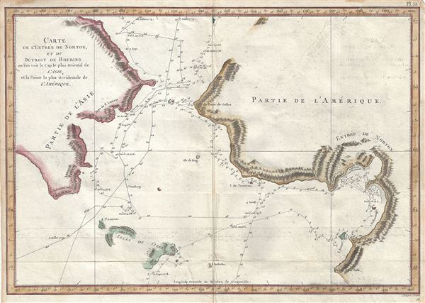
Carte de l'Entrée de Norton, et du Detroit de Bhering ou Von vou le Cap le plus oriental de l'Asie, et la Pointe la plus occidentale de l'Amerique.
1785 (undated) 11 x 15.5 in (27.94 x 39.37 cm) 1 : 1700000
1785 (undated) 11 x 15.5 in (27.94 x 39.37 cm) 1 : 1700000
Description
This is a scarce and important 1785 map of the Pacific Northwest, Alaska and the Bering Strait depicting the two expeditions of Captain Cook. It covers the Bering Strait from the Chukchi Sea north of Cape Prince of Wales south to St. Lawrence Island (Isle de Clerke) inclusive of Norton Sound and the Seward Peninsula of Alaska and the eastern tip of Russia. Capes, islands and bays are identified with relief beautifully rendered. The routes taken by Cook and the HMS Resolution between 1778 and 1779 is noted in some detail with soundings throughout
Cook was the first to accurately chart the Alaskan coastline and provide a detailed mapping of the Aleutian Islands. After his discovery of the Hawaiian Islands, Cook sailed north in search of the Northwest Passage, only to be blocked by Arctic Ice. From the Oxford Dictionary of National Biography:
Cook returned to Hawaii, where he was killed in 1779, and the expedition continued under the command of Captain Clerke, who made a final attempt to pass through the Bering Strait. This map was engraved by Robert Bernard and was issued in the French edition of the Official Account of Cook's Third Voyage.
Cook was the first to accurately chart the Alaskan coastline and provide a detailed mapping of the Aleutian Islands. After his discovery of the Hawaiian Islands, Cook sailed north in search of the Northwest Passage, only to be blocked by Arctic Ice. From the Oxford Dictionary of National Biography:
The north-west coast of North America was sighted on 7 March and for the next six and a half months Cook carried out a running survey of some 4000 miles of its coast from Cape Blanco on the coast of Oregon to Icy Cape on the north coast of Alaska, where he was forced to turn back by an impenetrable wall of ice. A search for a route back to Europe north of Siberia also proved fruitless. During this cruise Cook became the first European to enter Nootka Sound on the north-west coast of Vancouver Island, where he remained for a month taking astronomical observations and cutting spars for use as spare masts and yardarms.Cook's discoveries on this, his third voyage to the Pacific, finally put to rest confused notations of a Sea of the West as well as hopes for the discovery of a Arctic northwest passage.
Cook returned to Hawaii, where he was killed in 1779, and the expedition continued under the command of Captain Clerke, who made a final attempt to pass through the Bering Strait. This map was engraved by Robert Bernard and was issued in the French edition of the Official Account of Cook's Third Voyage.
Cartographer
Captain James Cook (7 November 1728 - 14 February 1779) is a seminal figure in the history of cartography for which we can offer only a cursory treatment here. Cook began sailing as a teenager in the British Merchant Navy before joining the Royal Navy in 1755. He was posted in America for a time where he worked Samuel Holland, William Bligh, and others in the mapping of the St. Lawrence River and Newfoundland. In 1766 Cook was commissioned to explore the Pacific and given a Captaincy with command of the Endeavour. What followed were three historic voyages of discovery, the highlights of which include the first European contact with eastern Australia, the discovery of the Hawaiian Islands (among many other Polynesian groups), the first circumnavigation of New Zealand, some of the first sightings of Antarctica, the first accurate mapping of the Pacific Northwest, and ultimately his own untimely death at the hands of angry Hawaiians in 1779. The influence of Cook work on the mapping and exploration of the Pacific cannot be understated. More by this mapmaker...
Condition
Very good. Some offsetting and foxing. Original platemark visible. Some wear along original fold lines.