1897 Garcia Cubas Map of Mexico City, Federal District
DistritoFederal-garciacubas-1897$800.00

Title
Distrito Federal.
1897 (dated) 19.25 x 23 in (48.895 x 58.42 cm) 1 : 245000
1897 (dated) 19.25 x 23 in (48.895 x 58.42 cm) 1 : 245000
Description
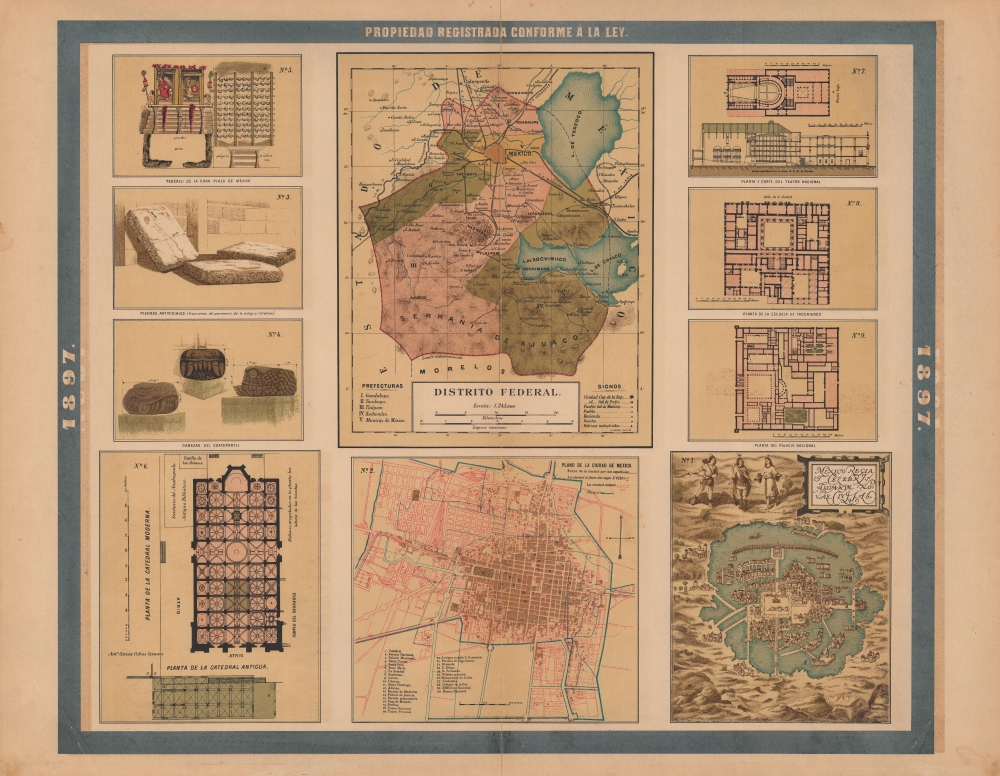
A colorful and fascinating sheet of maps and plates published in the 1897 edition of the Atlas Geográfico de los Estados Unidos Mexicanos. Together, the panels provide an overview of the history and present (1897) status of Mexico City and its environs.
Additional panels depict:
A Closer Look
The sheet consists of ten panels, with a 'main' map, including the title and appearing at top-center, covering the entire federal district consisting of Mexico City and its hinterland. Cities and towns, haciendas, ranchos, roads, railways, mountains, waterways, and administrative districts are indicated in the style common to the other maps in the Atlas Geográfico. Below the main map is a city plan (panel No. 2) of Mexico City highlighting its historic core and aqueducts, along with important historical and contemporary sites.Additional panels depict:
- No. 1 - Braun and Hogenberg's 1572 view 'Mexico Regia et Celebris Hispaniae Novae Civitas' from their Civitatus Orbis Terrarum.
- No. 3 - Artificial stones from the 'antiqua Catedral,' which likely refers to the oldest portion of the Metropolitan Cathedral, designed by Juan de Zumárraga in the mid-16th century, which was demolished in the late 16th century after the current structure began to be constructed around it.
- No. 4 - Serpent heads from a Coatepantli (Wall of Serpents) bas relief.
- No. 5 - The Templo Mayor (Teocalli de la Gran Plaza de México), with its famous 'skull rack.'
- No. 6 - Plan of the 'modern cathedral' (Metropolitan Cathedral).
- No. 7 - Plan and cross-section of the Gran Teatro Nacional.
- No. 8 - Plan of the School of Engineering.
- No. 9 - Plan of the Palacio Nacional.
Publication History and Census
This sheet was published in Mexico City in 1897 by Vega y Cie. It is based on the 1887 work of Antonio García Cubas and was updated with additional border work for the 1897 issue of the Atlas Geográfico de los Estados Unidos Mexicanos. The atlas is represented in several institutional collections but is extremely scarce on the market. The individual maps, likewise, are scarce to the market.Cartographer
Antonio Garcia y Cubas (July 24, 1832 - February 9, 1912) was a Mexican cartographer, writer, engineer, and geographer active in Mexico City in the second half of the 19th and the early 20th centuries. He is considered Mexico's first great geographer. Garcia y Cubas was born in Mexico City. He was orphaned at birth and was raised by is aunt. When he turned 18, he enrolled in the Dirección General de Industria, a government sponsored technical school. There he studied engineering and geography, which he further pursued at the Colegio de San Gregorio, Colegio de Ingenieros. He graduated with honors in geography and from 1856, became a member of the Sociedad Mexicana de Geografía y Estadística. His geographical work earned him the Order of Guadalupe, a Mexican second empire honorific, directly from the Emperor Maximillian. He published several atlases, including his important Atlas Geográfico, Estadístico e Histórico de la República Mexicana, and multiple decorative chromolithograph Atlas Pintoresco e Históricos covering Mexico, Cuba, Spain, and elsewhere. Today his work is scarce and highly desirable. More by this mapmaker...
Source
García Cubas, Antonio, Atlas Geográfico de los Estados Unidos Mexicanos, (Mexico City: Vega) 1897.
Atlas Geográfico de los Estados Unidos Mexicanos is a grand-format folio atlas of Mexico. It is based largely upon the Atlas Geográfico y Estadístico de los Estados Unidos Mexicanos published in 1887 by Antonio García Cubas and Debray. The present atlas incorporates the same maps, but adds a dramatic silver and gold border, which obscures the 1886 García Cubas imprint. It was issued during Porfirio Díaz's third term as president of Mexico - a period marked by rapid expansion of infrastructure and industry, including railroads, mines, bridges, roads, and broad scale electrification and waterworks. The atlases title page in this 1897 edition, celebrates Diaz with a large portrait and dedication. We have identified at least two editions of this atlas, both bearing the 1897 date: one by Cadena y Cie, features a red title page, another by Vega y Cie, featuring a blue title page. All 1897 editions we have identified have the silver borders, but these seem to be overprinted to cover an earlier gold border, with unidentifiable text and dating behind. We have been unable to find any examples with only the gold border. The atlases in general are showpieces of Mexican lithography in the golden age of the Porfiriato.
Condition
Fair. Centerfold separations repaired and reinforced. Closed tear extending 2 inches from printed area just to the right of the centerfold repaired on verso. Closed tears extending 1 inch into printed area in both bottom corners professionally repaired.
References
Rumsey 5758.028 (1886 edition).