This item has been sold, but you can get on the Waitlist to be notified if another example becomes available, or purchase a digital scan.
1924 Poole Bros. Map of the 'Dixie Route' from Chicago to Florida (Dixie Flyer)
DixieRteScenicRte-poolebros-1924$175.00


Title
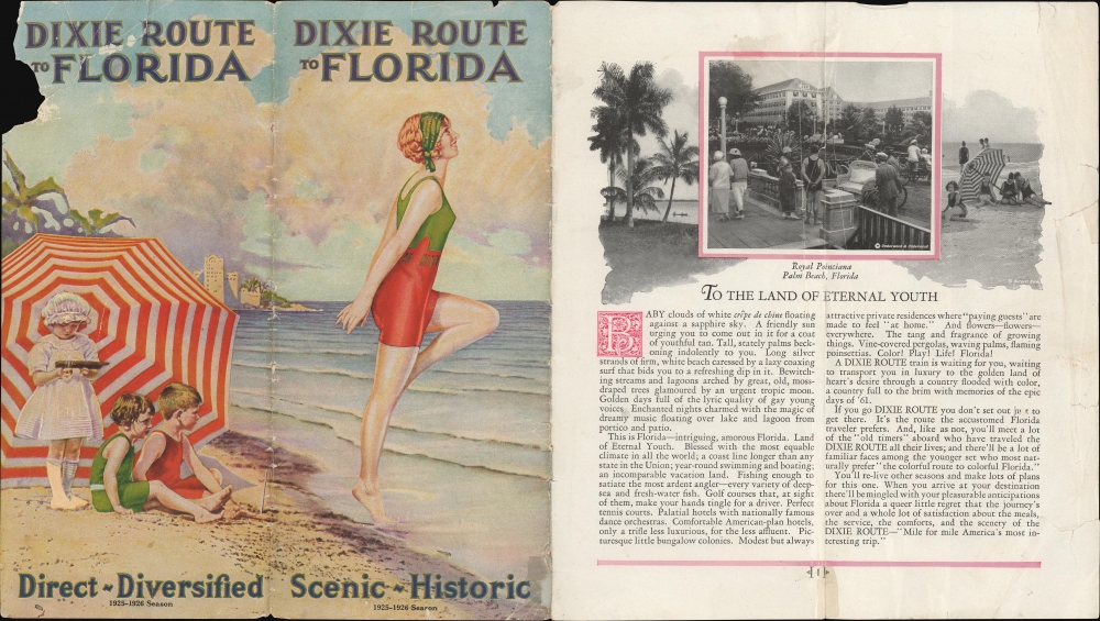
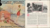
The Dixie Route is the Scenic Route. / Dixie Route to Florida.
1924 (dated) 15 x 8 in (38.1 x 20.32 cm) 1 : 7000000
1924 (dated) 15 x 8 in (38.1 x 20.32 cm) 1 : 7000000
Description
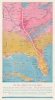
This is a 1924 Poole Brothers map of the 'Dixie Route' from Chicago, Illinois, to Jacksonville, Florida, which was operated by the named passenger train, the Dixie Flyer. The Dixie Flyer brought passengers from Chicago and St. Louis to Jacksonville for over 60 years.
A Closer Look
The map highlights the Dixie Route from Chicago to Jacksonville and connecting railroads. Stops along the Flyer's route are labeled, including Evansville, Indiana; Nashville, Tennessee; Chattanooga, Tennessee; Atlanta, Georgia' Macon, Georgia; and Jacksonville, Florida, along with the branch to St. Louis, Missouri, which was the other terminus of the Dixie Flyer. The railroads that operated each section of the route are identified with abbreviations. No state borders are illustrated, lending a more artistic flair to this piece.The Dixie Flyer
The Dixie Flyer was a named passenger train that operated from 1892 until 1966. The first service known as the Dixie Flyer operated between Nashville, Tennessee, and Jacksonville, Florida, and was only two sleeper cars. Service as a full train from Chicago, Illinois, to Jacksonville, Florida, began in January 1904, which caused the overnight sleeper cars to be discontinued. Several railroads mutually provided the service from Chicago to Jacksonville. They were the Chicago and Eastern Illinois; the Louisville and Nashville; the Nashville, Chattanooga, and St. Louis; the Central of Georgia; and the Atlantic Coast Line. The Florida Coast Line and the Atlantic Coast Line provided continuing service to Miami. The Nashville, Chattanooga, and St. Louis Railway had operated the Dixie Flyer from its inception in the 1890s and put time and effort into advertising and promoting the service. This proved beneficial when competition finally began to enter the market for rail travel from the Midwest to Florida in the 1910s. At the train's peak in the 1920s, as many as three different named trains, the Dixie Flyer, Dixie Limited, and Dixie Express, would operate during certain times of the year. The Dixie Flyer 's final run was a round trip between Atlanta and Chattanooga on January 20, 1966.Publication History and Census
This map was created and published by Poole Brothers in October 1924 and published by Poole Brothers in a 'Dixie Route' brochure in September 1925. A record exists in OCLC for this piece, but it represents a digital copy that has been populated throughout the database.Cartographer
Poole Brothers (1878 - 1968) were a Chicago based firm active in the late 19th and early 20th century with an initial focus on promotional railroad maps. Poole Brothers was founded by George Amos Poole (March 20, 1843 – September 7, 1918). In 1868, Poole, along with his uncle William H. Rand (1828 - 1915) and Andrew McNally (1836 - 1904), purchased the Chicago Tribune's job printing plant and formed the firm Rand McNally. In 1878, he left Rand McNally to form, with his brother William H. Poole, Poole Brothers, a direct competitor to Rand McNally for the lucrative railroad business. Like many of its competitors, Poole Brothers maintained an office on Chicago's Printer's Row (downtown Loop district). Their earliest known work is an 1880 map of Yellowstone National Park. In 1887, Poole Brothers, Andrew McNally, and several others formed the United Typothetae of America, a master printers association. In 1848, they were cited, along with Rand McNally and George Cram, by the Federal Trade Commission for price fixing. Their earliest known work is an 1880 map of Yellowstone National Park. Afterward they went on to produce a vast range of maps and other print products including tickets, cards, coupons, and restaurant menus. In time Poole Brothers merged with Newman-Randolph, which was then acquired by the American Can Company in the early 1960s. The American Can Company liquidated its printing concerns later in the same decade. More by this mapmaker...
Condition
Very good. Light wear along original fold lines. Old staple holes along centerfold. Text on verso. Accompanied by unbound original tourist booklet, which is in fair condition with some loss to the cover and old cellophane tape repairs. Image 1 and Image 2 are not the recto and verso of the same sheet.
References
Bogle, J.G., 'The Dixie Flyer', in The Railway and Locomotive Historical Society Bulletin (April 1971, No. 124) pp. 18-21. OCLC 978976167.