1704 / 1729 Cornelis Cruys Chart of the Don River, Russia
Don-cruys-1704$3,250.00


Title
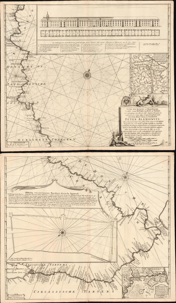
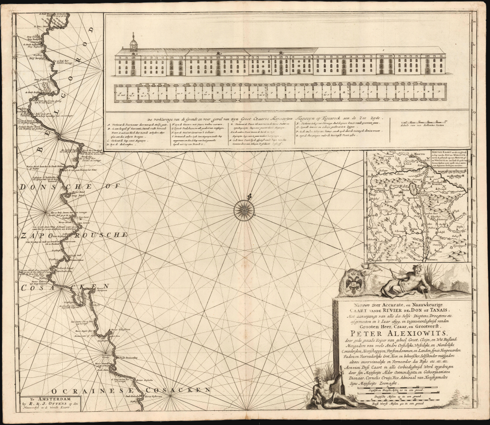
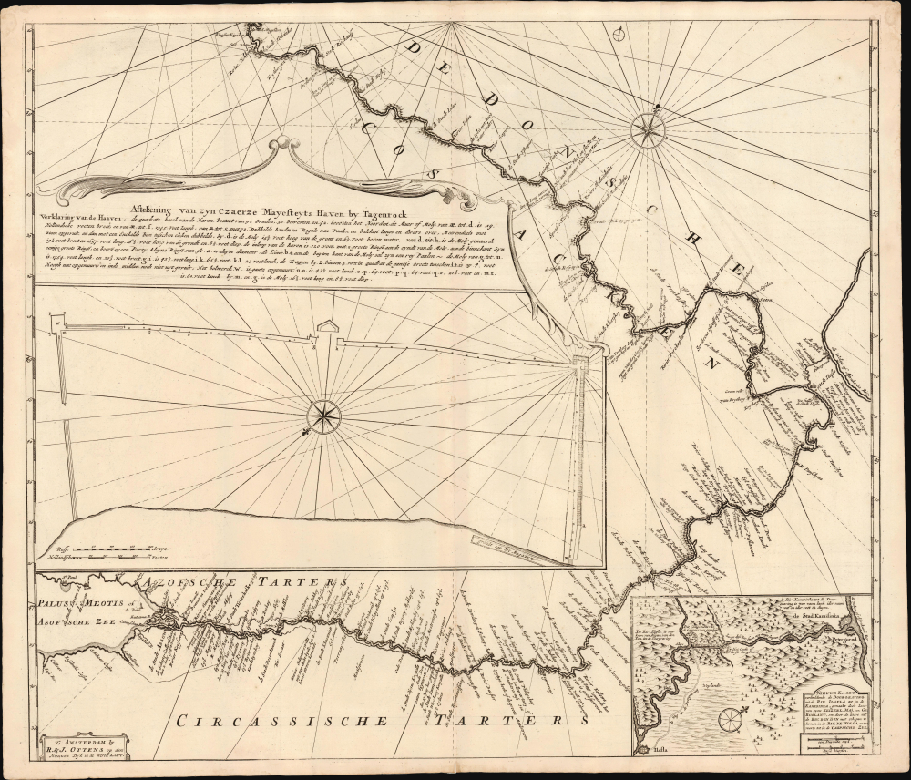
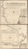
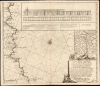
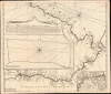
Nieuwe zeer Accurate, en Naauwkeurige Caart vande Rivierde Don of Tanais, Met aanwijzinge van alle des Selfs Dieptens, Droogtens etc. afgemeeten in 't Iaar 1699.
1704 (undated) 40.25 x 23.5 in (102.235 x 59.69 cm) 1 : 642000
1704 (undated) 40.25 x 23.5 in (102.235 x 59.69 cm) 1 : 642000
Description
This is Cornelis Cruys' rare, two-sheet chart of the Don River, the first modern astronomical survey of that waterway, based on his 1699 observations made while accompanying Peter the Great and the new Russian Black Sea Fleet from Voronezh to Azov. The plates were engraved by Hendrick Doncker for inclusion in Cruys' 1704 atlas of the Don; the present example is of the c. 1729 state, updated and printed by the Ottens firm for inclusion in their atlases. All states of the chart are rare, with the Doncker all but unacquirable.
Ottens' edition of this chart contains two further insets not present in Doncker's: a map focusing closely on a proposed canal connecting the Volga and the Don via the Ilovlya River, and a detailed map of the headwaters of the Don, emphasizing the established land route between Moscow and Voronezh. (These maps had not appeared in the Doncker edition because each was represented by a dedicated sheet in the Cruys atlas.) The map of the upper Don is in most respects identical to the dedicated map appearing in the atlas, with the major exception that Ottens' work includes a distinctive, tree-lined thoroughfare connecting Moscow and Voronezh not present on the Doncker state of the map. We do not see this route on any earlier map and are not aware of contemporary maps to show it. By 1711, Voronezh had become the most prominent southern Russian city due to the influence of its shipyards. The map's described 'beaten track from Moscow to Woronitz, planted with trees on both sides, 3 hours wide, provided with convenient inns' seems hard to miss, and its absence from later and contemporary maps suggests that it, as with Peter's Volga-Don canal, may have been a proposed development.
The work of surveying the Don preceded Cruys; as early as 1698, Russian hydrographers Vasily Zaretsky and Luka Zubov had begun surveys of the Voronezh and the Don as far as Korotoyak. Laval had charted the lower Don; under his authority, surveys of the mouth of the Don and the Sea of Azov had begun. But Cruys' thorough survey '...with indications of all its depths, droughts, etc. measured in the year 1699, in the presence of the Great Lord, Czar and Grand Prince Peter Alexiowits' would provide the basis for an authoritative charting of the river. By employing modern instruments and systematically including astronomical observations, Cruys was able to achieve a precision beyond his precursors.
He knew what he had. When Cruys returned to Holland briefly in 1702 on a recruiting trip for the Russian Navy, he brought his manuscript charts to Hendrick Doncker to be engraved for publication in atlas form. His Nieuw Pas-kaart Boek, Behelsende De Groote Rivier Don or Tanais may have been completed as early as 1703, but the work was not dated. The atlas contained descriptive text, pages of coastal profiles, twelve particular charts of the Don, the abovementioned maps of the upper Don and the proposed Don-Volga Canal, and this two-sheet general chart of the full course of the Don with its details of Taganrog, and a chart of the planned canal between the Don and the Volga. The general two-sheet chart, according to Bagrow, would appear with a new imprint in Ottens' c. 1729 Atlas Major.
A Closer Look
This two-sheet chart follows the Don from its confluence with the river Voronezh in the north to its mouth on the Sea of Azov. Cities and towns along the course of the river are named; the progress of Peter's flotilla is recorded from June 10 to the fleet's July 2 arrival at Azov. Cruys' astronomical measurements of latitude are marked along the river periodically, and characteristics along the shore are described. He notes problematic passages and dangerous currents as well. (Despite the claim in the title that the chart gives depths, there are none evident.) While the chart does not detail the lands away from the river, the surrounding territories are labeled, including the domains of the Azov and Circassian Tatars, the Don and Zaporizhian Cossacks, and the Ukrainian Cossacks.The Insets
Cruys' chart, as engraved by Doncker for inclusion in the Don atlas, featured two large insets: a detailed chart of Taganrog (Russia's first purpose-built naval port on the Sea of Azov) and a view and plan of the port's armory. Its presence here is of a piece with the chart itself: Peter's control over the Don and its surrounding territory was reinforced by his establishment of the port at Taganrog, and Peter placed Cruys himself as the naval town's first mayor.Ottens' edition of this chart contains two further insets not present in Doncker's: a map focusing closely on a proposed canal connecting the Volga and the Don via the Ilovlya River, and a detailed map of the headwaters of the Don, emphasizing the established land route between Moscow and Voronezh. (These maps had not appeared in the Doncker edition because each was represented by a dedicated sheet in the Cruys atlas.) The map of the upper Don is in most respects identical to the dedicated map appearing in the atlas, with the major exception that Ottens' work includes a distinctive, tree-lined thoroughfare connecting Moscow and Voronezh not present on the Doncker state of the map. We do not see this route on any earlier map and are not aware of contemporary maps to show it. By 1711, Voronezh had become the most prominent southern Russian city due to the influence of its shipyards. The map's described 'beaten track from Moscow to Woronitz, planted with trees on both sides, 3 hours wide, provided with convenient inns' seems hard to miss, and its absence from later and contemporary maps suggests that it, as with Peter's Volga-Don canal, may have been a proposed development.
Building a Russian Navy and Executing the First Scientific Survey of the Don
This map was closely tied to Peter I's efforts to produce, from scratch, a modern Russian navy. During his famous 1697 visit to Amsterdam, Peter recruited scholars, sailors, and craftsmen to enter Russian service; among the first of these was Cornelis Cruys, then Amsterdam's Depot Master for the Dutch Navy. Rewarded with a vice-admiralship in the as-yet-nonexistent Russian Navy, Cruys preceded Peter back to Russia, to Voronezh (on the Don tributary of the same name), where he was tasked with building Peter's new Black Sea fleet. Peter joined him there in 1699 to personally oversee the work. In June of that year, he sailed the new fleet down the Don to Azov. Cruys accompanied him with the flotilla, charting the Don in detail en route.The work of surveying the Don preceded Cruys; as early as 1698, Russian hydrographers Vasily Zaretsky and Luka Zubov had begun surveys of the Voronezh and the Don as far as Korotoyak. Laval had charted the lower Don; under his authority, surveys of the mouth of the Don and the Sea of Azov had begun. But Cruys' thorough survey '...with indications of all its depths, droughts, etc. measured in the year 1699, in the presence of the Great Lord, Czar and Grand Prince Peter Alexiowits' would provide the basis for an authoritative charting of the river. By employing modern instruments and systematically including astronomical observations, Cruys was able to achieve a precision beyond his precursors.
He knew what he had. When Cruys returned to Holland briefly in 1702 on a recruiting trip for the Russian Navy, he brought his manuscript charts to Hendrick Doncker to be engraved for publication in atlas form. His Nieuw Pas-kaart Boek, Behelsende De Groote Rivier Don or Tanais may have been completed as early as 1703, but the work was not dated. The atlas contained descriptive text, pages of coastal profiles, twelve particular charts of the Don, the abovementioned maps of the upper Don and the proposed Don-Volga Canal, and this two-sheet general chart of the full course of the Don with its details of Taganrog, and a chart of the planned canal between the Don and the Volga. The general two-sheet chart, according to Bagrow, would appear with a new imprint in Ottens' c. 1729 Atlas Major.
Publication History and Census
These plates were engraved in and around 1704 by Hendrick Doncker for inclusion in Cornelis Cruys' Nieuw pas-kaart boek behelsende de groote rivier Don of Tanais. The atlas itself is rare; we see perhaps a dozen examples in OCLC. The separate map, in its first state, is cataloged nowhere and has appeared neither in dealers' catalogs nor at auction. The present example, printed around 1729 by Reiner and Joshua Ottens for inclusion in their atlases, appears on the market from time to time, but it, too, is rare: we see only 6 examples in institutional collections.CartographerS
Cornelis Cruys (June 14, 1655 - June 14, 1727) was a Norwegian sailor and naval officer, best known for his service in the Dutch Navy, and later the Imperial Russian Navy on behalf of Tsar Peter the Great, under whom he rose to an admiralship. He was born Niels Olufsen in Stavanger, Norway. Eventually, he moved to the Dutch Republic, changing his name in the bargain. He married in Amsterdam in 1681, by which time he had already been captain of a merchant ship for a year. He became a citizen of the city seven months later. He continued as a merchant until 1696, when he joined the Dutch Navy. He received a posting as Naval Depot Master in Amsterdam, but he did not stay. Following Peter I of Russia's famed visit to the Dutch Republic in 1697, Cruys was one of the first sailors and skilled workers to accompany Peter back to Russia; he would enter Peter's service as a vice admiral of the navy and an advisor on nautical and naval matters. Under Cruys' guidance, Russia built a modern navy essentially from scratch. Cruys was tasked with building a Black Sea fleet to counter Turkey in the south; Cruys was then given the Mayoralty of the newly-founded Don fortified port of Taganrog, which guarded the approaches to the Don River from the Sea of Azov. He would serve as commander of the Russian Baltic fleet in the opening years of the Great Northern War with Sweden. He continued in his service in Russia for a quarter of a century, attaining the rank of Admiral in 1721. He died in 1727. Cruys is credited with having produced the first detailed, printed charts of the Sea of Azov and the Don River. More by this mapmaker...
Hendrick Doncker (1626 - 1699) (a.k.a. Henri Donker) was a Dutch bookseller and publisher of sea charts and nautical atlases active in Amsterdam during the middle part of the 17th century. He maintained a presence on Nieuwe Brugsteeg, Amsterdam. He married Elizabeth Abrahamsd Rensing in 1647. Doncker was somewhat unique to this period in that he did not copy the work of earlier cartographers, instead producing his own map. Moreover, Doncker's charts were widely admired for their constant revision and overall accuracy. In addition to producing his own charts, he also collaborated with Pieter Goos and Anthonie Jacobsz to producing the pilot guide De Zeespiegel. Following his 1699 death, Doncker's remaining stock and valuable map plates were acquired by Johannes van Keulen. He was survived by a daughter, Anna Doncker. Learn More...
Ottens (fl. c. 1680 - 1785) was a prominent Amsterdam map publishing family active for nearly 100 years. Joachim Ottens (1663 - 1719) was born in Amsterdam to a family of seafarers and educated in Amsterdam's Evangelical Lutheran community. He likely learned copperplate engraving under Frederick de Wit (1629 - 1706), for whom he worked until about 1710. In 1710, he was admitted to the Sint-Lucasgilde (Guild of St. Luke) and, in 1711, Joachim founded his own firm. Although Joachim died only a few years later, in 1719, his widow continued the business, either publishing as either 'I. Ottens', 'Ottens', or 'In de Wereldcaert' [In the World Map]. In 1726, Joachim Otten's sons, Renier (1698 - 1750) and Joshua (1698 - 1750), established a partnership and generally published as 'R. and I. Ottens'. Although they ran separate shops, on Nieuwendijk and Kalverstraat, they worked jointly as a singular business until Renier's death in 1750, at which point Joshua assumed full control. After Joshua's death in 1765, his widow continued the firm with their son, Renier II, changing the imprint to 'Joshua and Reinier Ottens.' Joshua's widow, Johanna de Lindt, held an auction sale of their engraved plates in 1784. Ottens' work stands out in that all of their maps were separate issues, though often found compiled into special, made-to-order multi-volume composite Atlas factice works, such as the Atlas. Some examples of the Atlas include over 800 separately issued maps. Because they were not uniformly issued in standard atlases, Ottens maps are often of the utmost rarity and are notable for their exceptionally rich engraving. Learn More...
Condition
Very good. Few marginal mends, else excellent. Upper sheet 20 x 23.5, lower 20.25 x 23.5.
References
OCLC Bagrow, L., A History of Russian Cartography up to 1800, pp. 98-102.