This item has been sold, but you can get on the Waitlist to be notified if another example becomes available, or purchase a digital scan.
1874 Barnes and Smith City Plan or Map of Philadelphia, Pennsylvania, and Vicinity
DrivingPhiladelphia-barnessmith-1874$275.00


Title
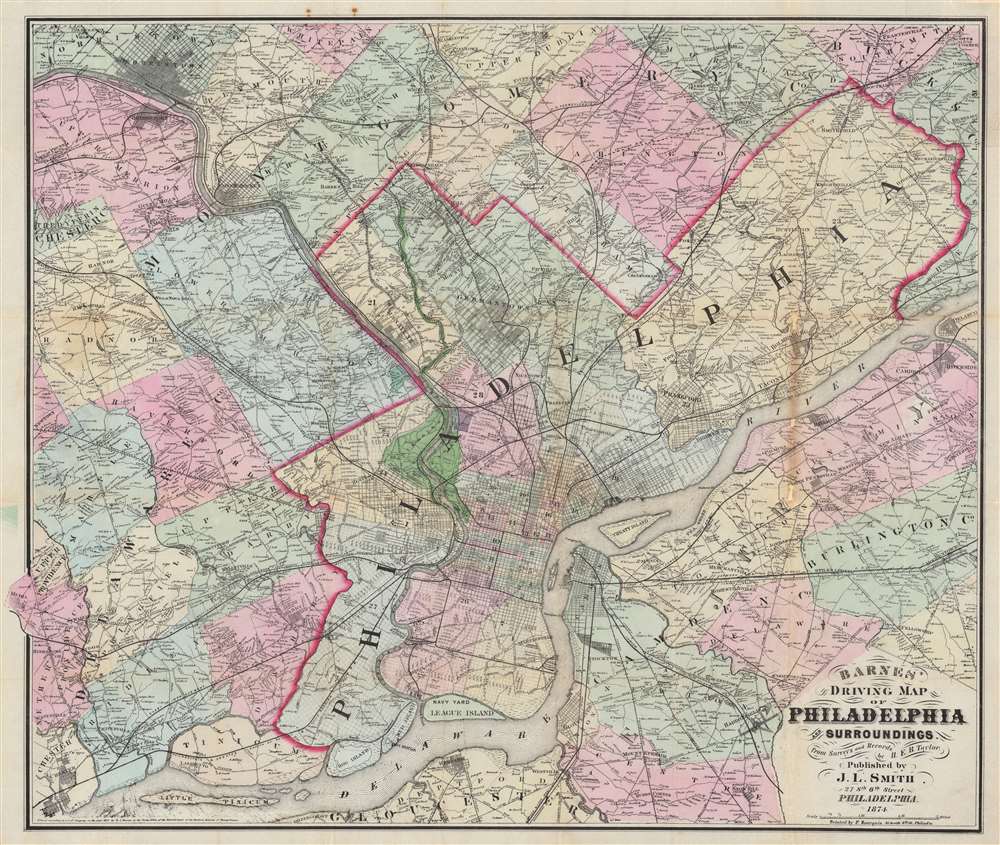
Barnes' Driving Map of Philadelphia and Surroundings.
1874 (dated) 25.25 x 30.25 in (64.135 x 76.835 cm) 1 : 52435
1874 (dated) 25.25 x 30.25 in (64.135 x 76.835 cm) 1 : 52435
Description
This 1874 John L. Smith map of Philadelphia presents a detailed picture of the city and vicinity, covering from Media and King of Prussia east to Delanco and Riverside and from Norristown south to the Delaware River. Philadelphia's streets are illustrated and labeled, and its city squares identified. Outside Philadelphia, many towns are illustrated with street grids. Individual homes are labeled by last name throughout.
Transportation Network
The map is intriguing for its detailed depiction of the transportation network in and around Philadelphia. Numerous rail lines are traced, including the Philadelphia and Reading Railroad, the Westchester Railroad, the Pennsylvania Central Railroad, and the Philadelphia Trenton Railroad. Turnpikes and plank roads, another important form of transportation, are marked by dashed black and white lines. Turnpike construction began in the 1790s as private toll roads. These toll roads created a means for better maintenance, which allowed for easier and safer transportation. In the 1840s, as railroad and canal construction began to boom, toll roads changed to free public use, which in turn led to a steep decline in road quality. This led to the implementation of plank roads, which were just like they sound - planks laid down to avoid ruts and other damage to dirt roads and less expensive than other road surfaces like macadam.Publication History and Census
This map was created and published by J. L. Smith from surveys and records by H. E. B. Taylor and printed in 1874 by Frederick Bourquin. We note a single cataloged example at the Hagley Museum and Library in Wilmington, Delaware. We are aware of just one other instance when this map appeared on the private market.CartographerS
John L. Smith (March 19, 1846 - April 1, 1921) was a Philadelphia based stationer, map seller, publisher, and printer active in the late 19th and early 20th centuries. Smith served in the Civil war with Company K, 118th Pennsylvania, the 'Corn Exchange Regiment' from roughly 1862. He served in the Battle of North Anna and Bethesda Church, where he was wounded. He mustered out of service in 1865 and settled in Philadelphia. Smith subsequently worked with Rufus L. Barnes (1794 - 1868), whose business he acquired in 1868. His offices were at 27 South Sixth Street, Philadelphia. He retired from the map business in 1920. Smith rose to prominence and wealth and, when he died, left a large estate of $54,500 USD to charity. He had no children and lived as a bachelor at the Columbia Club, 1600 North Broad Street, until his death of a heart attack in 1921. He had a brother, William C. Smith, who survived him. More by this mapmaker...
Rufus L. Barnes (fl. c. 1840 - 1867) was an American map publisher and seller based in Philadelphia during the early to mid-19th century. Barnes opened a map shop in Philadelphia in 1840 from which issued numerous maps on his account as well as reselling the work of others. Rufus' manuscript ledger, which is preserved in the Newbury Library, reveals connections to most of the prominent map publishers and cartographers of his period, including Robert Pearsall Smith, C.K. Stone, A.R.Z. Dawson, A. Pomeroy & Co., D.J. Lake and Company, Henry F. Walling, S. Willard Treat, John Homer French, R.S. Taintor, Jr. and Co., William Otis Shearer, surveyor Silas N. Beers, engravers Worley and Bracher, A.D. Ellis, Green and Wilbur, and O.W. Gray and Son. His work was used by both sides during the American Civil War and included some of the best Pennsylvania county maps available at the time. Barnes notably partnered with William Ellis Morris to reissue John Melish's important wall map of Pennsylvania in 1848. Barnes sold his business to his assistant John L. Smith in 1867. Learn More...
Frederick Bourquin (1808 - 1897), also spelled Bourgin, was a Swiss American engraver and lithographer active in Philadelphia in the mid- to late-19th century. Bourquin was born in Bern, Switzerland, and emigrated to the United States in 1817 accompanied by his brother, Charles F. Bourquin, also an engraver. They lived briefly in Bucks County, Pennsylvania, and New York City, before relocating to Philadelphia in 1829 to join the lithographic firm of Kennedy and Lucas. Bourquin was naturalized as a U.S. citizen in 1834. From 1842 the brothers worked for Peter Stephen Duval (1804/5 - 1886) at 'P. S. Duval and Co.' They became partners in the firm in 1857. In 1858, Frederick left Duval to partner with Robert Pearsall Smith (1827 - 1898), one of the lead publishers in the Philadelphia-based county map and state atlas industry, publishing as 'F. Bourquin and Company' (602 Chestnut Street). Smith completely and inexplicably retired from publishing around 1865, leaving the business to Bourquin. Subsequently Bourquin shared premises and often published with William Bracher's (1829 - 1912) firm, 'Worley and Bracher'. In the mid-1850s Bourquin relocated to Camden, New Jersey, where he served on the City Council from the 1870s - 1880s and in the New Jersey State legislature in 1872. His sons, Frederick Bourquin, Jr., Gordon M. Bourquin, David L. Bourquin, and Charles L. Bourquin, were all, to a greater or lesser extent, involved in the lithographic and/or printing business. Learn More...
Condition
Good. Wear and some toning along original fold lines. Areas of infill along a fold line and at a handful of fold intersections.
References
OCLC 81492987.