1926 Bacon Map of Dublin, Ireland
Dublin-bacon-1926$350.00


Title
Bacon's plan of Dublin and suburbs.
1926 (undated) 30.5 x 27 in (77.47 x 68.58 cm) 1 : 10560
1926 (undated) 30.5 x 27 in (77.47 x 68.58 cm) 1 : 10560
Description
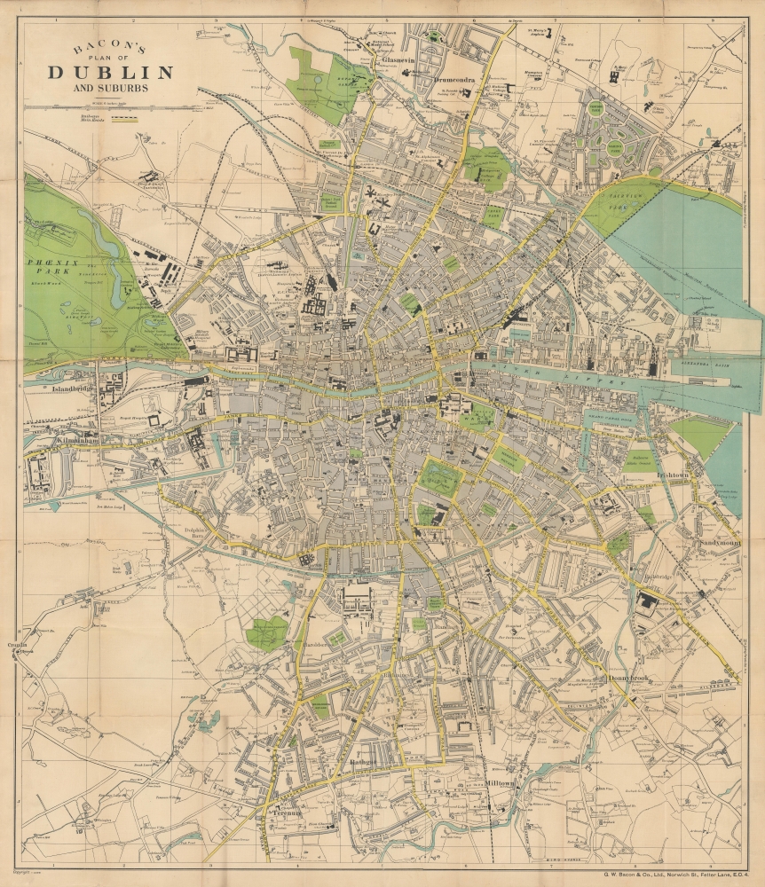
A highly detailed c. 1926 map of Dublin, Ireland published by G.W. Bacon and Co. It was produced soon after Ireland's turbulent revolutionary period and reflects the lingering effects of the conflict.
Northeast of the city center, planned 'garden city' suburbs are evident in Marino Park and Croydon Park. Several military facilities appear, which are helpful in dating. The names 'McKee Barracks,' the 'Civic Guard Depot,' 'Colins Barracks,' and others all suggest the late 1920s, when these names were adopted.
Historians debate the extent of support for the uprising in Dublin at the outset, but the heavy-handed British response undoubtedly angered many and converted them to supporters of republicanism. During the Irish War of Independence (1919 - 1921), Dublin saw assassinations and other guerrilla-style attacks, which were responded to with more executions and reprisal atrocities, especially at the hands of the 'Black and Tans.'
During the Irish Civil War (1922 - 1923), Irish Republican Army forces hostile to the Anglo-Irish Treaty seized the Four Courts near center here, leading to a tense standoff with pro-treaty forces of the new provisional government, led by Michael Collins, who had recently been one of the most successful anti-British guerrilla fighters. Under pressure from the British, who threatened to send troops back to Dublin to suppress the anti-treaty rebels, Collins ordered the Four Courts bombarded on June 28, 1922, often considered the opening shot of the Civil War. Nearly a year of assassinations (including of Collins), ambushes, and other attacks resulted in an uneasy truce. The Collins Barracks, just to the west of the Four Courts, was named in honor of the slain republican leader.
A Closer Look
Coverage embraces municipality of Dublin along with suburbs to the north and south. Hospitals, train stations, prisons, workhouses, schools and universities, barracks, and other public institutions are indicated with black, parks, football grounds, and school campuses with green, major roads with yellow, and waterways with blue. Industrial and commercial facilities line the city's east side, especially north of the River Liffey. The 'Brewery' along James St. is the Guinness Brewery (also known as the St. James's Gate Brewery), one of several breweries and distilleries noted. Handwritten annotations point out the location of the original city walls in the vicinity of Dublin Castle.Northeast of the city center, planned 'garden city' suburbs are evident in Marino Park and Croydon Park. Several military facilities appear, which are helpful in dating. The names 'McKee Barracks,' the 'Civic Guard Depot,' 'Colins Barracks,' and others all suggest the late 1920s, when these names were adopted.
Building a Free Ireland
The decade that preceded this map was a tumultuous for Ireland. Long-simmering Irish republican sentiment burst during the 1916 Easter Rising, when hundreds of rebels and volunteers seized key sites throughout Dublin. The British rushed in reinforcements, including heavy weapons, and managed to suppress the uprising after a week of intense street fighting. The rebels' ad hoc headquarters at the General Post Office (here as 'Post Office' on O'Connell St.) was heavily damaged in the fighting, and most of the leaders of the uprising were later executed at the Kilmainham Gaol, just beyond the scope of this map at left.Historians debate the extent of support for the uprising in Dublin at the outset, but the heavy-handed British response undoubtedly angered many and converted them to supporters of republicanism. During the Irish War of Independence (1919 - 1921), Dublin saw assassinations and other guerrilla-style attacks, which were responded to with more executions and reprisal atrocities, especially at the hands of the 'Black and Tans.'
During the Irish Civil War (1922 - 1923), Irish Republican Army forces hostile to the Anglo-Irish Treaty seized the Four Courts near center here, leading to a tense standoff with pro-treaty forces of the new provisional government, led by Michael Collins, who had recently been one of the most successful anti-British guerrilla fighters. Under pressure from the British, who threatened to send troops back to Dublin to suppress the anti-treaty rebels, Collins ordered the Four Courts bombarded on June 28, 1922, often considered the opening shot of the Civil War. Nearly a year of assassinations (including of Collins), ambushes, and other attacks resulted in an uneasy truce. The Collins Barracks, just to the west of the Four Courts, was named in honor of the slain republican leader.
Publication History and Census
This map was published around the year 1926 by G.W. Bacon. Due to uncertainty over the map's date and how many editions of a map with this title exist, it is difficult to establish a precise census. However, maps with the same title as the current example are included in five OCLC listings with speculative dates ranging from 1916 to 1937 and are held by thirteen institutions worldwide. For reasons explained above we can assume with a fair degree of confidence that this map dates from 1926 or soon thereafter. As some catalog listings include the copyright information at the bottom-left corner, we are able to establish that there are at least two editions of a map with this title (Copyright L-570 and Copyright K2399). The present edition looks to be held by five institutions in the United States: the New York Public Library, Rice University, Skidmore College, the University of Texas at Austin, and the University of California Berkeley.Cartographer
George Washington Bacon (1830 - 1922) was a London based book and map publisher active in the mid to late 19th century. Bacon's firm G.W. Bacon and Co. purchased the plates created by Edward Weller for the Weekly Dispatch Atlas then modified and updated them for several of their own important atlases, including The New Ordnance Atlas of the British Isles. In 1893, Bacon & Co. acquired the map publishing business of J. Wyld. Then, around the turn of the century, Bacon & Co. itself was folded into the Scottish publishing house of W.& A.K. Johnston. More by this mapmaker...
Condition
Good. Backed on linen. Reinforced on verso at fold intersections. Wear on fold lines and fold intersections, minor areas of loss at fold intersections.
References
OCLC 940139274.