This item has been sold, but you can get on the Waitlist to be notified if another example becomes available, or purchase a digital scan.
1890 Poole Brothers View Map of the Great Lakes
DuluthSouthShore-poolebros-1890$325.00

Title
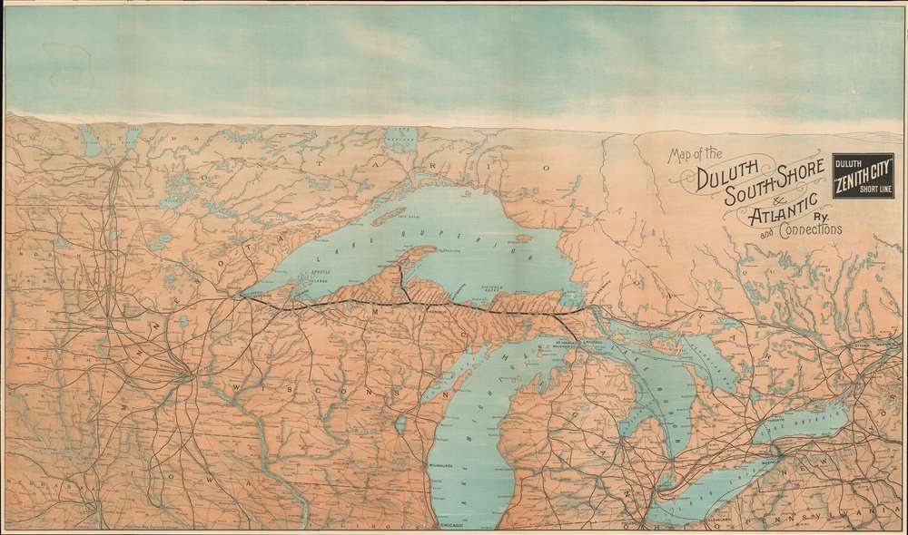
Map of the Duluth South-Shore and Atlantic Ry. And Connections. / Duluth 'Zenith City' Short Line.
1890 (undated) 21.5 x 36.5 in (54.61 x 92.71 cm) 1 : 1710000
1890 (undated) 21.5 x 36.5 in (54.61 x 92.71 cm) 1 : 1710000
Description
A stunning c. 1890 chromolithograph railroad map and view of the Great Lakes region. Issued to illustrate the route of the Duluth South-Shore and Atlantic Railway, the map covers from Montreal to the Dakotas, including all five Great Lakes, and most of Michigan, Wisconsin, Minnesota, North Dakota, and South Dakota. The map takes unusual view/map form, commonly seen in New England and European maps, but uncommon in maps of the American Midwest. While the map itself is presented on a uniform scale, the cartographer uses shading and a horizon line to suggest view-like qualities.
Duluth, South Shore and Atlantic Railway
The Duluth, South Shore and Atlantic Railway was founded in 1886 by the Detroit tycoon James McMillan. The railroad followed the development of hematite mines in the Upper Peninsula in the 1850s. This led to the construction of numerous small private railroads and spur lines. McMillan consolidated and merged many of these lines starting the early 1880s. Two years after its founding, in 1888, the DSSA was acquired by the Canadian Pacific Railroad, who financed additional trackwork as far as Duluth. The DSSA is still owned by the Canadian Pacific. Parts have been integrated into the Soo Line Railroad, while other sections are operated as a heritage line. Running through the stunning Upper Peninsula, the DSSA is one of the most beautiful railroad lines in the United States.Chromolithography
Chromolithography is a color lithographic technique developed in the mid-19th century. The process involved using multiple lithographic stones, one for each color, to yield a rich composite effect. Oftentimes, the process would start with a black basecoat upon which subsequent colors were layered. Some chromolithographs used 30 or more separate lithographic stones to achieve the desired effect. Chromolithograph color could also be effectively blended for even more dramatic effects. The process became extremely popular in the late 19th and early 20th centuries, when it emerged as the dominate method of color printing.Publication History and Census
This promotional map was issued by the railroad publisher Poole Brothers, probably on behalf of the railroad itself. It is a 2-color chromolithograph. The map is uncommon, with the OCLC identifying only 5 institutional holdings.Cartographer
Poole Brothers (1878 - 1968) were a Chicago based firm active in the late 19th and early 20th century with an initial focus on promotional railroad maps. Poole Brothers was founded by George Amos Poole (March 20, 1843 – September 7, 1918). In 1868, Poole, along with his uncle William H. Rand (1828 - 1915) and Andrew McNally (1836 - 1904), purchased the Chicago Tribune's job printing plant and formed the firm Rand McNally. In 1878, he left Rand McNally to form, with his brother William H. Poole, Poole Brothers, a direct competitor to Rand McNally for the lucrative railroad business. Like many of its competitors, Poole Brothers maintained an office on Chicago's Printer's Row (downtown Loop district). Their earliest known work is an 1880 map of Yellowstone National Park. In 1887, Poole Brothers, Andrew McNally, and several others formed the United Typothetae of America, a master printers association. In 1848, they were cited, along with Rand McNally and George Cram, by the Federal Trade Commission for price fixing. Their earliest known work is an 1880 map of Yellowstone National Park. Afterward they went on to produce a vast range of maps and other print products including tickets, cards, coupons, and restaurant menus. In time Poole Brothers merged with Newman-Randolph, which was then acquired by the American Can Company in the early 1960s. The American Can Company liquidated its printing concerns later in the same decade. More by this mapmaker...
Condition
Backed on archival tissue. Some wear on original fold lines.
References
Newberry Library, G 909 .73. OCLC 35065115.