1867 Beers Map of Dutchess County, New York
DutchessCountyNY-beers-1867$350.00

Title
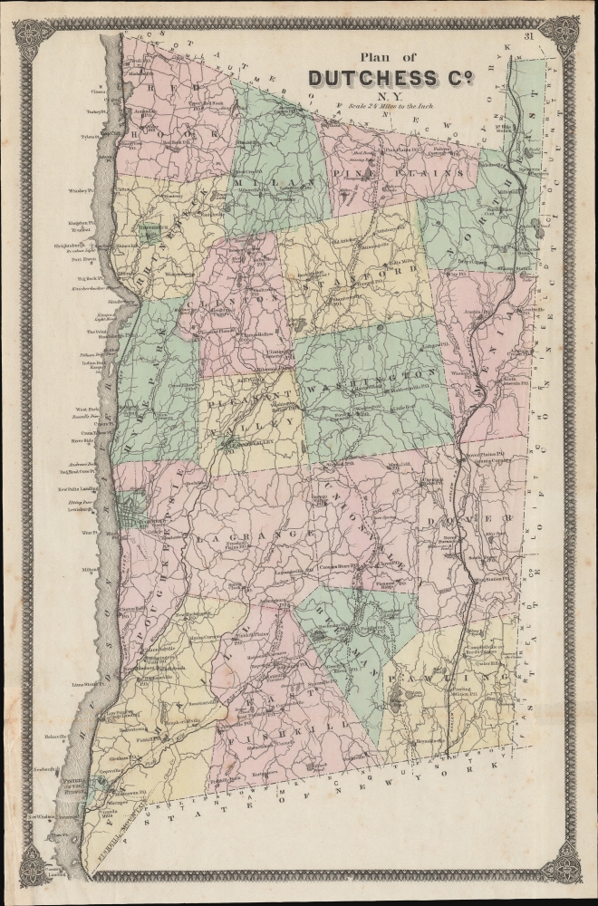
Plan of Dutchess Co. N. Y.
1867 (undated) 20.25 x 13.5 in (51.435 x 34.29 cm) 1 : 134640
1867 (undated) 20.25 x 13.5 in (51.435 x 34.29 cm) 1 : 134640
Description
A lovely example of F. W. Beers 1867 map of Dutchess County, New York that appeared in his Atlas of New York and Vicinity from Actual Surveys. This area is known for its scenic beauty, historical significance (especially its association with the Roosevelts), and educational institutions, notably Vassar College.
A Closer Look
Towns and cities, including Rhinebeck, Poughkeepsie, Fishkill, and Hyde Park (hometown of Franklin Delano Roosevelt and now the site of his presidential library), are color shaded for easy differentiation. Villages (often noted with a post office, 'P.O.'), roads, rail lines, waterways, mountains, and other features are noted throughout. In addition to the Hudson River Railroad and Harlem Railroad (now the Metro North), proposed railroads (the Boston, Hartford, and Erie Railroad, 'New York Railroad,' and Dutchess and Columbia Railroad) are indicated. Points, ferry landings, lighthouses, and settlements are recorded along both banks of the Hudson River. The location of Vassar College, founded just six years prior as a women's college, is recorded just outside of the center of Poughkeepsie. Neighboring counties of Columbia and Putnam in New York, and Fairfield and Litchfield in Connecticut are noted.Publication History and Census
This map was prepared by Frederick William Beers and published in 1867 in the Atlas of New York and Vicinity from Actual Surveys. Six printings of this atlas were issued in 1867, which differ considerably from each other (analyzed in Barbara McCorkle's 1990 article 'The Strange Case of E.W. Beers and the Atlas of New York and Vicinity'). The present map appeared in two of these printings (see Rumsey 0063.034, and 4631.034).CartographerS
The Beers family (Fredrick, Silas, James and Daniel) (fl. c. 1850 - 1886), along with Charles and Augustus Warner, were prominent map publishers working from the 1850s to the late 1880s. Often publishing under the Warner & Beers designation, the combined firms produced a series of important state and county atlases and map of much of the northeastern United States. Many of their regional maps are among the most detailed and well laid out maps ever produced of their respective regions. Because Warner & Beers county maps were often detailed down to the individual homes and landowners, they have become highly sought after by general and family historians. In additional to producing maps of surpassing detail, Warner & Beers also maintained an earlier generation's attention to detail and quality while publishing in an era ever increasingly dominated by the low cost printing methods used by the publishing empires of Rand McNally and George Cram. More by this mapmaker...
Frederick William Beers (August 17, 1839 - September 8, 1933) was an American map publisher, cartographer, and surveyor. Beers was born in Maryland, the son of map publisher James Botsford Beers (October 16, 1811 - June 3, 1901), but lived much of his life in New York where he was the chief of the map division and Commissioner of Public Records in Brooklyn. He joined the family business in 1870 and along with his father, published the Farm Line Atlas of the County of Kings and the Atlas of Long Island. He is credited with personally mapping every county in New York State. Frederick worked with his family into the mapmaking trade, including his brother, Charles Henry Beers (November 3, 1813 - March 5, 1892), and nephews Silas Norman Beers (September 3, 1837 - May 12, 1873) and Daniel Glover Beers (October 19, 1841 - February 12, 1913). He retired from the publishing business in 1930, when he was more than 90 years old. He died on September 8, 1933 in Bridgeport, Connecticut. Learn More...
Source
Beers, F. W., Atlas of New York and Vicinity, (New York: Beers, Ellis, Soule) 1867.
Condition
Good. Some toning and creasing along old fold lines.
References
Rumsey 0063.034. Barbara McCorkle, 'The Strange Case of E.W. Beers and the Atlas of New York and Vicinity' (Meridian, 5:39-43).