This item has been sold, but you can get on the Waitlist to be notified if another example becomes available, or purchase a digital scan.
1755 Bolton Map of Southeast Asia, the East Indies, China, Korea, and Japan
EastAsia-bolton-1755$1,125.00

Title
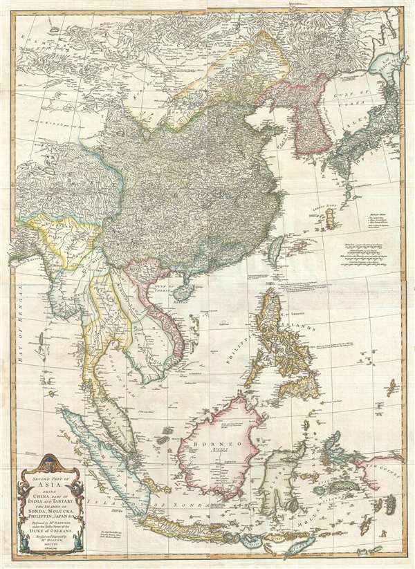
Second part of Asia, being China, part of India and Tartary: the islands of Sonda, Molucka, Philippin, Japan and c.
1755 (dated) 38 x 28 in (96.52 x 71.12 cm) 1 : 7350000
1755 (dated) 38 x 28 in (96.52 x 71.12 cm) 1 : 7350000
Description
An exceptional 1755 map of East Asia by Malachy Postlethwayte and Solomon Bolton. Centered on the South China Sea, the map covers from Mongolia to java and from the Bay of Bengal to Hokkaido and new Guinea. It includes the countries of China, Japan, Taiwan (Formosa), Korea, the Philippines, Vietnam (Tonquin and Chochine), Laos, Cambodia, Thailand (Siam), Pegu (Burma, Myanmar), Tibet, Malay, Singapore, Sumatra, and Borneo, as well as most of modern day Indonesia. Cartographically the map is derived from Jean Baptiste Bourguignon d'Anville's 1752 map of the same region, with numerous idiosyncratic Anglocentric annotations and revisions typical of Postlethwayte. Of course, the map is also primarily in English. Otherwise, Bolton has done an excellent job of adapting d'Anville's work for the English market and, as such, the map follows d'Anville with some precision.
Overall this map is deceptively sophisticated and dense, so much so that one is immediately inclined to praise its depth without considering its cartographic shortcomings. On the whole, d'Anville presents a highly impressive map of a region then only tenuously understood by European geographers. Korea is notably square at the base. Hokkaido, or Yesso, is attached to the Japanese mainland as well as grossly malformed. Okinawa is so massively oversized that it nearly eclipses Taiwan - a clear indication that D'Anville is drawing from Japanese manuscript sources that typically mapped the island as such. The map's density rapidly diminishes as once moves south out of China into the lesser known kingdoms of Southeast Asia and the East India Islands. While the major river systems are mapped with some accuracy, particularly in Pegu (Burma), Siam (Thailand), Laos, and Cambodia, the remainder of the region is vague at best. The interiors, with the exception of Java and the Philippines, both of which had been aggressively mapped by the Dutch and Spanish, respectively, are generally empty and vague. The Straits of Singapore (Sin Capura) are noted and the island of Singapore is present, if unlabeled.
One item of some note is a great wall in Vietnam separating the kingdoms of Tonkin and Cokinchina (Chochina), essentially North and South Vietnam. Although very little is known about this wall, it is factual. William Dampier reported observing the wall when he visited Vietnam in 1688. It was built in 1540 by the Chinese to mediate a conflict between the Trinh and Nguyen Vietnamese. Today little remains of this legendary wall.
Engraved by R. W. Seale, this map was issued in the second edition of Postlethwayt's Dictionary of Trade and Commerce, 1757. The first edition, published in 1751, did not contain any maps. The second edition was issued in 1757, and was the first to incorporate maps, including the present offering. A third edition was followed in 1766 and fourth edition was published posthumously in 1774.
CartographerS
Malachy Postlethwayt (c. 1707 - 1767) was a British economist and commercial expert famous for his publication of the commercial dictionary titled The Universal Dictionary of Trade and Commerce in 1751. The dictionary was a translation and adaptation of the Dictionnaire économique of the French Inspector General of the Manufactures for the King, Jacques Savary des Brûlons. Malachy claims to have spent nearly 20 years adapting and researching his important dictionary, which attained a popular following. The second edition of the Dictionary issued in 1752, was updated with a series of fine maps based upon D'Anville's work, but updated by Postlethwayt to reflect his political and social views. Politically Postlethwayt was extremely conservative and highly patriotic though his views more often than not took the form of rants against the social and political enemies of the British Empire. In the mid-1740s Postlethwayt lobbied for the Royal Africa Company and was known for his pro-slavery advocacy. His belief that the slave trade had a place in the larger "political arithmetic" of empire, promoted through his many popular books and other publications, in time became the party line for the ruling class. Despite his misguided feelings about the Africa slave trade, Postlethwayt was an influential and thoughtful economist whose ideas influenced Adam Smith, Samuel von Pufendorf, Alexander Hamilton, and others. Postlethwayt also commonly spelled his name as Postlethawyte and Postlethwait. More by this mapmaker...
Jean Baptiste Bourguignon d'Anville (1697 - 1782) was perhaps the most important and prolific cartographer of the 18th century. D'Anville's passion for cartography manifested during his school years when he amused himself by composing maps for Latin texts. There is a preserved manuscript dating to 1712, Graecia Vetus, which may be his earliest surviving map - he was only 15 when he drew it. He would retain an interest in the cartography of antiquity throughout his long career and published numerous atlases to focusing on the ancient world. At twenty-two D'Anville, sponsored by the Duke of Orleans, was appointed Geographer to the King of France. As both a cartographer and a geographer, he instituted a reform in the general practice of cartography. Unlike most period cartographers, D'Anville did not rely exclusively on earlier maps to inform his work, rather he based his maps on intense study and research. His maps were thus the most accurate and comprehensive of his period - truly the first modern maps. Thomas Basset and Philip Porter write: "It was because of D'Anville's resolve to depict only those features which could be proven to be true that his maps are often said to represent a scientific reformation in cartography." (The Journal of African History, Vol. 32, No. 3 (1991), pp. 367-413). In 1754, when D'Anville turned 57 and had reached the height of his career, he was elected to the Academie des Inscriptions. Later, at 76, following the death of Philippe Buache, D'Anville was appointed to both of the coveted positions Buache held: Premier Geographe du Roi, and Adjoint-Geographer of the Academie des Sciences. During his long career D'Anville published some 211 maps as well as 78 treatises on geography. D'Anville's vast reference library, consisting of over 9000 volumes, was acquired by the French government in 1779 and became the basis of the Depot Geographique - though D'Anville retained physical possession his death in 1782. Remarkably almost all of D'Anville's maps were produced by his own hand. His published maps, most of which were engraved by Guillaume de la Haye, are known to be near exact reproductions of D'Anville' manuscripts. The borders as well as the decorative cartouche work present on many of his maps were produced by his brother Hubert-Francois Bourguignon Gravelot. The work of D'Anville thus marked a transitional point in the history of cartography and opened the way to the maps of English cartographers Cary, Thomson and Pinkerton in the early 19th century. Learn More...
Richard William Seale (December 1703 - May 25, 1762) was an English a mapmaker and engraver active in London during the middle part of the 18th century. Seale was the son of Richard and Elizabeth Seale. Richard, his father, was a member of the Stationers Company, suggesting that printing and engraving must have been a family trade. Nonetheless, he did not learn the trade from his father, but rather from Samuel Parker of Clerkenwell, to whom he was apprenticed in 1719. Seale was extremely active as an engraver and publisher from about 1740 until his death in 1762. His cartographic corpus is vast; including pieces engraved for most other notable English cartographers of his period: Willdey, Baron, Toms, Rocque, Basire, Bowles, Benning, among others. In addition to cartographic work, Seale also produce numerous architectural engravings. Learn More...
Source
Postlethwayte, M., Mr. Postlethwayt's Universal Dictionary of Commerce, London), 1757.
Condition
Very good. Four panels joined. Slight offset where joined.
References
OCLC 940385275. Suarez, Thomas, Early mapping of Southeast Asia, (Hong Kong: Periplus) page 254, fig 160.