This item has been sold, but you can get on the Waitlist to be notified if another example becomes available, or purchase a digital scan.
1834 Blunt Map of the United States East Coast: New York City to St. John's River, Florida
EastCoast-blunt-1834$750.00

Title
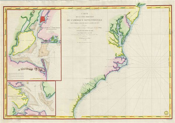
Carte de la Cote Orientale de l'Amerique Septentrionale Partie Comprise Entre New York et la Riviere Saint Jean.
1834 (dated) 25 x 36 in (63.5 x 91.44 cm)
1834 (dated) 25 x 36 in (63.5 x 91.44 cm)
Description
This is a highly scarce 1834 map of the eastern coast of the United States. The map covers the entire coastline from New York City to the St. John River in Florida, inclusive of the Chesapeake Bay, the Outer Banks, and the Carolina, Virginia, and Georgia coastlines. Two inset maps are included on the left. The upper map details the entrance to New York Harbor from Sandy Hook to Manhattan and from Staten Island to Rockaway Inlet. The lower inset details the entrance to the Chesapeake Bay. The whole is typical of nautical charts, offering limited inland detail but a wealth of nautical information including countless depth soundings, shore lines, river soundings, shipping lanes, and other practical information for the mariner. A fine example of a working sea chart.
Cartographically this map was derived from the work of e. Blunt an American hydrographer and chart maker active in the private sector. It was updated and revised in 1834 by J. M Hacq and Chassant for issue by the French Depot-General da la Marine. The lower right corner bears the 'Depot General de la Marine' imprint. The map is dedicated to the King of France, Louis-Philippe, whose short post-Napoleon reign is best known as the July Monarchy.
Cartographically this map was derived from the work of e. Blunt an American hydrographer and chart maker active in the private sector. It was updated and revised in 1834 by J. M Hacq and Chassant for issue by the French Depot-General da la Marine. The lower right corner bears the 'Depot General de la Marine' imprint. The map is dedicated to the King of France, Louis-Philippe, whose short post-Napoleon reign is best known as the July Monarchy.
CartographerS
Edmund March Blunt (June 20, 1770 - 1862) was an American navigator, bookseller, chartmaker, and cartographer based in Newburyport, Massachusetts. Blunt was born in Portsmouth, New Hampshire in 1770. In 1796, along with the nominal assistance of prominent navigator Captain Lawrence Furlong, Blunt published The American Coast Pilot, one of the most important published works on American navigation. Although much of the work was plagiarized from British publications, the Coast Pilot was an immediate popular success. In response to the popularity of his work, Blunt published 21 subsequent editions, each with important updates and revisions. The first edition to contain map plates was printed in 1804. Following a fire that destroyed his offices at The Sign of the Bible in 1811, Blunt moved his business to New York and opened a new shop, The Sign of the Quadrant. His sons Edmund Jr. (1799 - 1866) and George William (1802 - 1878), joined the firm in 1824 and eventually took over the family business, renaming the firm 'E. and G. W. Blunt'. They both produced their own nautical books, charts, and instruments, as well as republished their father’s work. In 1830, Edmund accepted a position under Ferdinand Hassler at the United States Office of the Coast Survey. Much of Blunt's original work eventually found its way into U.S. Coast Survey Publications. George closed the firm in 1872 and sold the plates and chart copyrights to the U.S. Coast Survey and the U.S. Navy Hydrographic Office. Due to the quality and detail of Blunt's work, revised editions of his most important charts were republished well into the 1880s. More by this mapmaker...
Dépôt des Cartes et Plans de la Marine (fl. 1720 - present), often called the Dépôt de Marine, was a French hydrographic mapping organization founded in 1720 under Charles-Hercule of Albert de Luynes (1674 - 1734). Much like the U.S. Coast Survey, the British Admiralty, and the Spanish Deposito Hydrografico, the Dépôt was initiated as a storehouse and distribution center of existing nautical and marine charts. Eventually the Dépôt initiated its own mapping activities in an attempt to improve and expand upon existing material. Some of the more prominent cartographers and hydrographers associated with the of Dépôt des Cartes were, Philippe Buache, Jacques-Nicholas Bellin, Giovanni Rizzi-Zannoni, Rigobert Bonne, and Jean Nicolas Buache. Learn More...
Condition
Very good. Original centerfold visible. Blank on verso. Minor fill repair lower left corner.