
1963 / 1981 Aramco Map of Eastern Arabia, Onshore and Offshore Oil Fields

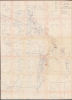
Road Map Eastern Province Saudi Arabia.
Aramco's Transition to Nationalization and Offshore Fields
Aramco's Transition to Nationalization and Offshore Fields
This is a rare, large-format 1963 map of eastern Arabia, updated to 1981, produced by the Arabian American Oil Company (Aramco). In addition to including Saudi Arabia's largest and most important onshore oil fields, it also marks several offshore oil fields at a time when offshore oil exploration and exploitation was increasing.A Closer Look
The map covers from the contemporary Saudi-Kuwaiti Neutral Zone in the north to Qatar in the south. Villages, roads (paved, unpaved, and 'of questionable permanency'), terrain (including sabkhahs or saltflats), water wells, and intermittent waterways (or wadis) are indicated throughout, according to the symbols and lines in the legend to the left of the title. The main focus is on oil and gas fields and related infrastructure, including oil wells, gas wells, injection wells, pipelines, plants, triangulation stations, and power lines. A great number of local placenames are transliterated, and the boundaries of both onshore and offshore oil fields are traced, including the Dammam and Ghawar Fields and the offshore Safaniya Field. Several locations important to the industry are shaded brown, and handwritten annotations denoting pipelines appear near Al-Hofuf and Abqaiq. At the bottom right is an inset map of the Shaybah Oil Field and environs on the disputed Saudi border with Abu Dhabi. The remote location was only developed in the 1990s, with the eponymous settlement of Shaybah being built and Aramco bringing the project on-stream in 1998, with a pipeline linking to Abqaiq.Historical Context
This map was first issued in 1963, a transformative era for the eastern coast of Arabia as oil exploration shifted from desert sands to the waters of the Persian Gulf. Building on the early success of Safaniya (at center-top here), the world's largest offshore field discovered in the 1950s, operators leveraged rapid advancements in marine drilling technology to unlock vast undersea reserves. This decade witnessed a flurry of landmark discoveries, including Saudi Arabia's Zuluf (1965) and Marjan (1967) Fields, at top here, just to the left of the title and legend.The momentum towards offshore drilling accelerated through the 1970s and early 1980s, a period fundamentally reshaped by skyrocketing oil prices and resource nationalism. Following the 1973 Oil Crisis, regional governments aggressively transitioned from concession agreements with foreign majors to full state ownership, giving rise to state-controlled giants like the nationalized Saudi Aramco.
Brief History of Aramco
In 1933, Standard Oil of California (Chevron) was granted a concession by the Saudi government (still in the process of unifying the country) to seek oil reserves under a subsidiary, the California-Arabian Standard Oil (CASOC), which employed American geologists, including veterans of the U.S. Geological Survey. After several years of searching with little success, the company finally hit paydirt at Dhahran in 1938, an event which drastically changed the history of the Arabian Peninsula and the world. In 1944, CASOC changed its name to the Arabian American Oil Co. (Aramco), and in the postwar period, it flourished. A dispute with King Abdulaziz in 1950 led to the company splitting profits with the Saudi government. Thus, even though a consortium of American oil companies initially owned Aramco, the profit-sharing arrangement incentivized both the Saudi and the U.S. governments, seeking to support American corporations and provide cheap oil to American consumers, to continuously seek out and exploit additional reserves.Moves towards effective nationalization increased, particularly after the 1973 Yom Kippur War, when the Saudi government took a one-quarter share of Aramco's assets and, over the following months, acquired a majority of the company's shares. The company nominally operated under the terms of the concessionary agreement until 1988, when a new entity, the Saudi Arabian Oil Company (Saudi Aramco), took over Aramco's assets and operations. It is now one of the largest companies in the world by revenue, operating over 100 oil and gas fields, and has been publicly traded on the Saudi stock exchange since 2019.
Publication History and Census
This map was initially prepared by Aramco in 1963, then updated repeatedly in the following years (a full list of updates is noted to the left of the title), with the present example being an update of May 31, 1981. It was drawn by one Whb Aid, presumably an abbreviation of a surveyor's name. We are only aware of one example of this map in any edition in institutional collections, a 1971 update held at the Library of Congress.Cartographer
Arabian American Oil Company (active 1932 - Present) Dhahran-based Aramco (now Saudi Aramco (Arabic: أرامكو السعودية ʾArāmkū s-Saʿūdiyyah) is a Saudi Arabian public petroleum and natural gas company. Initially named California-Arabian Standard Oil Co., it was formed by a coalition of American companies seeking new sources of oil, having been excluded from Mesopotamian oil fields by United Kingdom and France since 1920. In the late forties the company's headquarters were moved from New York to Dhahran, but the company maintained offices in the United States (including the company's P.R. department.) Further Details...
Condition
Very good. Some light dampstaining and wrinkling, folds a bit toned and with some nicks, some repaired with archival tape.
References
OCLC 420718676.