
This item below is out of stock, but another example (left) is available. To view the available item, click "Details."
Details
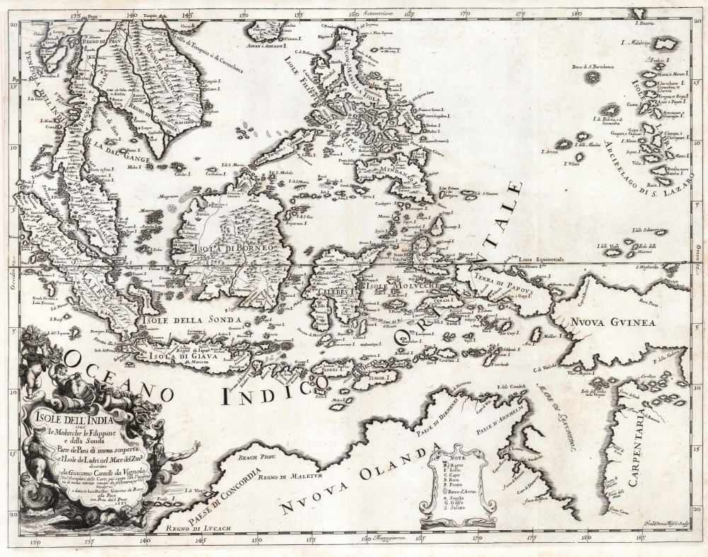
1683 Cantelli da Vignola Map of Southeast Asia, the Spice Islands and Australia
$1,500.00
1683 Cantelli da Vignola Map of Southeast Asia, the Spice Islands and Australia
EastIndia-cantellidavignola-1683-2$750.00

Title
Isole dell'India cio è le Molucche, le Filippine e della Sonda, parte de paesi di nuova scoperta e l'isole de Ladri nel mare del zud / descritte da Giacomo Cantelli de Vignola ; Fran. Donia Messis sculp.
1683 (dated) 17.5 x 22.75 in (44.45 x 57.785 cm) 1 : 12300000
1683 (dated) 17.5 x 22.75 in (44.45 x 57.785 cm) 1 : 12300000
Description
A rare, highly decorative 1683 map of Southeast Asia and the East Indies by Giacomo Cantelli da Vignola and Giacomo de Rossi.
There is a lush cartouche in the lower left surrounded by putti and Mer-men, bearing a wealth of sea-shells and cornucopia filled with spice-pods.
A Closer Look
The map depicts the Malay Peninsula, Cochinchina, and the kingdom of Siam. Sumatra, Java, Borneo, and the Spice Islands appear to be based primarily on the Dutch maps of the period, as is also the case with the Philippines. Singapore Island is named. The island 'Terra di Papous' is appears as a separate landmass from 'Nuova Guinea,' an error preserved from Nicolosi's large map of Asia, whose geography this map otherwise improves upon. The southern portion of the map is dominated by Nuova Olanda, that is to say, New Holland aka Australia. Much of the detail here appears to be drawn from Thevenot's map based on Tazman, but there are some place names retained from Marco Polo, such as the hypothetical provinces of Lucach and Maletur.There is a lush cartouche in the lower left surrounded by putti and Mer-men, bearing a wealth of sea-shells and cornucopia filled with spice-pods.
Publication History and Census
This map was prepared by Giacomo Cantelli da Vignola, engraved by Francisus Donia Messis, and published by Giacomo de Rossi in his c. 1683 Mercurio Geografico. We identify only three institutional collections to hold separate examples of this map: Princeton, the National Library Board of Singapore, and the Bibliothèque nationale de France. We count fifteen examples of the Mercurio Geografico in institutional collections.CartographerS
Giacomo Cantelli da Vignola (February 22, 1643 - November 30, 1695) was an important Italian cartographer and engraver active in 17th century Italy. Cantelli was born in Montorsello, near Vignola, Italy to a prominent local family. After studying literature at the University of Bologna, Cantelli took a position as secretary to the Marquis Obizzi de Ferrara. Eventually Cantelli relocated to Venice where he developed an interest in cartography. He later traveled to Paris in the company of the French ambassador where became acquainted with the French cartographer Guillaume Sanson, as well as his contemporaries Jacques-Andre Duval and Michel-Antoin Baudrand. It was most likely the influence of these innovative French cartographers that inspired Cantelli's careful and meticulous approach, in which he based his cartography not just on earlier maps, but also very much in the French style upon accounts written by travelers and merchants regarding actual travel to foreign lands. Back in Italy, Cantelli took service with Count Rinieri Marescotti, with whom he traveled extensively throughout Italy, becoming in the process acquainted with the Italian publisher Giovanni Giacomo de Rossi. It is with Rossi that Cantelli began officially publishing his maps. The earliest maps to bear the Cantelli-Rossi imprint date to 1672 and detail the Holy Land, Persia, and the Ottoman Empire. Around 1680 the duo also began to publish the Mercurio Geografico, a large format atlas illustrating all parts of the world in a splendid Italian baroque detail defined by elaborate finely engraved cartouche work, high quality paper, bold Roman lettering, and dark rich inks. Some have compared his style go that of Giovanni Antonio Magini, another Italian cartographer of the previous generation. Cantelli da Vignola in fact pioneered the Italian style of fine bold engraving that would eventually be embraced and expanded upon by Vincenzo Coronelli. His work drew the attention of Pope Innocent XI and Reggio Francesco II d'Este, the Duke of Modena, both of whom offered him a position as court geographer. Cantelli chose to work with the Duke of Modena, in the service of whom he produced numerous maps and well as two large globes. He died in Modena in November 1695. More by this mapmaker...
Giovanni Giacomo de Rossi (1627 - 1691) was an Italian engraver and printer, active in Rome during the second half of the 17th century. His father, Giuseppe de Rossi (1570 - 1639), was the founder of the most important and active printing press of the 17th century in Rome. The printing press was begun in 1633, by Giuseppe de Rossi, and it passed firstly to Giovanni Giacomo and to his brother Giandomenico (1619 - 1653), and then later to Lorenzo Filippo (1682-?), then Domenico de Rossi (1659 - 1730). Giovanni Giacomo de Rossi was most active between 1638 and 1691 and was to take the company to the height of its success. The artists that he printed the etchings for included Giovanni Benedetto Castiglione (1609 - 1665), Pietro Testa (1612-1650), and Giovan Francesco Grimaldi (1606 – 1680). Cartographically he is best known for producing the maps of Giacomo Cantelli da Vignola and publishing them in his c. 1683 Mercurio Geografico. In 1738 the firm became the Calcografia Camerale, from 1870 until 1945 the Regia Calcografica, and today it is known as the Calcografia Nazionale. The Calcografia Nazionale holds is one of the finest collections of early printing plates and prints in the world. Learn More...
Source
Rossi, G., Mercurio geografico overo guida geographica in tutte le partie del Modo, (Rome) 1683.
Condition
Good. Left margin extended; top margin extended with manuscript reinstatement of border. Else a very attractive example with a bold, sharp strike.
References
OCLC 495096742. Rumsey 11438.158. Saurez, T., Early Mapping of Southeast Asia…, p. 212.