This item has been sold, but you can get on the Waitlist to be notified if another example becomes available, or purchase a digital scan.
1794 Dunn and Laurie and Whittle Map of the East Indies and the Philippines
EastIndiaIslands-dunn-1794$275.00

Title
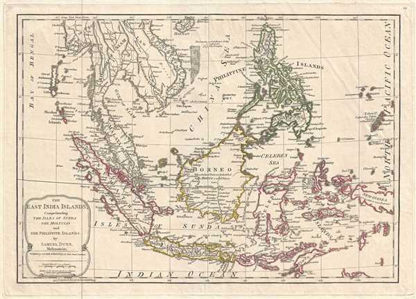
The East India Islands, Comprehending the Isles of Sunda the Maluccas and the Philippine Islands.
1794 (undated) 12.75 x 17.5 in (32.385 x 44.45 cm) 1 : 12000000
1794 (undated) 12.75 x 17.5 in (32.385 x 44.45 cm) 1 : 12000000
Description
This is a 1794 Samuel Dunn and Laurie and Whittle map of the East Indies and Southeast Asia. The map depicts the region from the Bay of Bengal to Palau and from Hainan to Java, Timor, and the Indian Ocean. Highly detailed, locations throughout the region are labeled. The islands of Luzon, Palawan, Mindoro, Mindanao, and Leyte are all labeled in the Philippines, along with Borneo, Celebes, Java, Sumatra, and the Maluku Islands in Indonesia. New Guinea is also labeled. In Southeast Asia, the Malay Peninsula, the Kingdom of Siam (Thailand), the Kingdom of Pegu (Burma or Myanmar), the Kingdom of Lao (Laos), the Kingdom of Camboja (Cambodia), and Cochinchina (Vietnam) are all illustrated and labeled. The Chinese island province of Hainan is also illustrated and labeled. Cities, towns, and villages throughout the region, including Malacca, Manila, Borneo, and Batavia, are labeled, along with coastal locations in most places. Rivers and mountain ranges are also illustrated.
This map was originally created and published by Samuel Dunn and this example was published by Laurie and Whittle in 1794.
This map was originally created and published by Samuel Dunn and this example was published by Laurie and Whittle in 1794.
CartographerS
Samuel Dunn (1723 - January 1794) was a teacher of mathematics, navigation, and astronomy, an engraver, and a publisher active in London, England, during the second half of the 18th century. Dunn was born in Crediton, Devonshire, England. He was active as a teacher of navigation, running his own school, as early as 1742, when he was just 19. In 1758 Dunn became master of an academy at Ormond House, Paradise Row, Chelsea, London. He is credited with observing the transit of a comet in January of 1760 and the thrust of Venus in 1761. Dunn was a member of the Commission for the Discovery of the Longitude at Sea. As such he was one of the few teachers appointed to issued ship masters with 'Certificates of Competence' for the Board of Longitude. Dunn was also an official teacher of navigation for the East India Company and succeeded William Herbert as the editor of the New Directory for the East Indies. He published a number of scientific and astronomical texts as well as several important maps and charts. He lived until his death at No. 1 Boar's Head Court, Fleet Street, London, England. More by this mapmaker...
Laurie and Whittle (fl. 1794 - 1858) were London, England, based map and atlas publishers active in the late 18th and early 19th century. Generally considered to be the successors to the Robert Sayer firm, Laurie and Whittle was founded by Robert Laurie (c. 1755 - 1836) and James Whittle (1757-1818). Robert Laurie was a skilled mezzotint engraver and is known to have worked with Robert Sayer on numerous projects. James Whittle was a well-known London socialite and print seller whose Fleet Street shop was a popular haunt for intellectual luminaries. The partnership began taking over the general management of Sayer's firm around 1787; however, they did not alter the Sayer imprint until after Sayer's death in 1794. Apparently Laurie did most of the work in managing the firm and hence his name appeared first in the "Laurie and Whittle" imprint. Together Laurie and Whittle published numerous maps and atlases, often bringing in other important cartographers of the day, including Kitchin, Faden, Jefferys and others to update and modify their existing Sayer plates. Robert Laurie retired in 1812, leaving the day to day management of the firm to his son, Richard Holmes Laurie (1777 - 1858). Under R. H. Laurie and James Whittle, the firm renamed itself "Whittle and Laurie". Whittle himself died six years later in 1818, and thereafter the firm continued under the imprint of "R. H. Laurie". After R. H. Laurie's death the publishing house and its printing stock came under control of Alexander George Findlay, who had long been associated with Laurie and Whittle. Since, Laurie and Whittle has passed through numerous permeations, with part of the firm still extant as an English publisher of maritime or nautical charts, 'Imray, Laurie, Norie and Wilson Ltd.' The firm remains the oldest surviving chart publisher in Europe. Learn More...
Condition
Very good. Even overall toning. Blank on verso.
References
OCLC 844775167.