This item has been sold, but you can get on the Waitlist to be notified if another example becomes available, or purchase a digital scan.
1757 Covens and Mortier Map of Southeast Asia and the Spice Islands
EastIndies-covensmortier-1757$1,125.00

Title
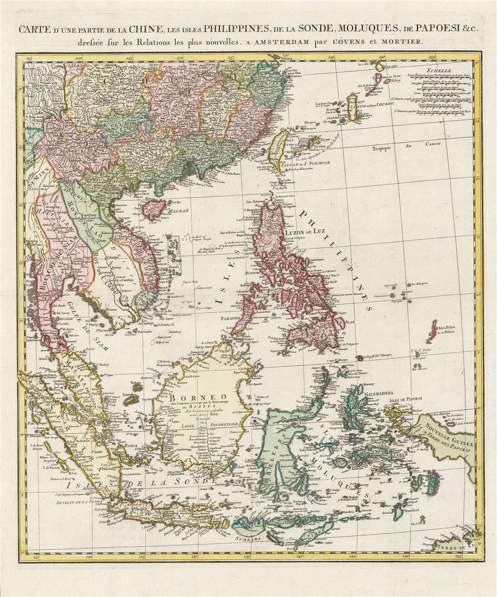
Carte d'une partie de la Chine, les isles Philippines, de la Sonde, Moluques, de Papoesi, etc.
1757 (undated) 22.75 x 19.75 in (57.785 x 50.165 cm) 1 : 8000000
1757 (undated) 22.75 x 19.75 in (57.785 x 50.165 cm) 1 : 8000000
Description
This is a 1757 Covens and Mortier map of southern China, the Malay Peninsula, and the East Indies. It includes Taiwan (Formosa), the Philippines, Vietnam (Tonquin and Cochinchine), Laos, Cambodia, Thailand (Siam), Malay, Singapore, Sumatra, and Borneo, as well as most of modern-day Indonesia. The map replaces earlier Covens and Mortier maps based on the work of Guillaume De l'Isle, instead drawing on newer maps by Jean Baptiste Bourguignon d'Anville.
Updating the Mapping of the East
Though Covens and Mortier were an Amsterdam publisher, this map's dense detail and overall sophistication reflect the continuing effort of French cartographers to come to grips with the geography East Asia, Southeast Asia, and the East Indies. Despite centuries of colonial engagement, geographical knowledge, especially of the interior, remained limited. D'Anville's influence is most apparent in the presentation of Vietnam and Cambodia. The Mekong Valley includes verbatim the notation from the French mapmaker's 1752 Seconde partie de la Carte d'Asie. Also, the present work includes a wall separating the Trịnh and Nguyễn kingdoms, which among European works first appears in D'Anville's maps. Similarly, the toponomy for the interior of Borneo is also drawn from directly from D'Anville. Although densely mapped with spurious geography on many earlier maps, here D'Anville's leaves open space, reflecting a lack of reliable data, rather than retain questionable outdated content - a convention typical of his scientific approach. The firm's use of D'Anville's cartography was neither plagiarism nor flattery, rather it resulted from a close ongoing relationship with D'Anville. In fact, the engraver Johannes Condet's father Claas, and brother Gerardus, both engraved for D'Anville.Publication History and Census
This map was engraved by Johannes Condet for inclusion in Covens and Mortier's 1757 Atlas Nouveau. We are aware of a single state. We see eleven examples of the separate map in institutional collections. It appears on the market from time to time.CartographerS
Covens and Mortier (1721 - c. 1862) was an Amsterdam publishing firm, the successor to the extensive publishing empire built by Pierre Mortier (1661 - 1711). Covens and Mortier maps are often criticized as derivative - but this is not fully the case. Pierre Mortier lived in Paris from 1681 to 1685. There he established close relationships the the greatest French cartographers of the era, including De L'Isle and D'Anville. His business model was based upon leveraging Dutch printing technology and sophistication to co-publish state of the art French cartography. Upon Mortier's death in 1711 his firm was taken over by his son, Cornelius Mortier (1699 - 1783). Cornelius married the sister of Johannes Covens (1697 - 1774) in 1721 and, partnering with his brother in law, established the Covens and Mortier firm. Under the Covens and Mortier imprint, Cornelius and Johannes continued in Pierre's model of publishing the most up-to-date French works with permission. They quickly became one of the largest and most prolific Dutch publishing concerns of the 18th century. The firm and its successors published thousands of maps over a 120 year period from 1721 to the mid-1800s. During their long lifespan the Covens and Mortier firm published as Covens and Mortier (1721 - 1778), J. Covens and Son (1778 - 94) and Mortier, Covens and Son (1794 - c. 1862). More by this mapmaker...
Jean Baptiste Bourguignon d'Anville (1697 - 1782) was perhaps the most important and prolific cartographer of the 18th century. D'Anville's passion for cartography manifested during his school years when he amused himself by composing maps for Latin texts. There is a preserved manuscript dating to 1712, Graecia Vetus, which may be his earliest surviving map - he was only 15 when he drew it. He would retain an interest in the cartography of antiquity throughout his long career and published numerous atlases to focusing on the ancient world. At twenty-two D'Anville, sponsored by the Duke of Orleans, was appointed Geographer to the King of France. As both a cartographer and a geographer, he instituted a reform in the general practice of cartography. Unlike most period cartographers, D'Anville did not rely exclusively on earlier maps to inform his work, rather he based his maps on intense study and research. His maps were thus the most accurate and comprehensive of his period - truly the first modern maps. Thomas Basset and Philip Porter write: "It was because of D'Anville's resolve to depict only those features which could be proven to be true that his maps are often said to represent a scientific reformation in cartography." (The Journal of African History, Vol. 32, No. 3 (1991), pp. 367-413). In 1754, when D'Anville turned 57 and had reached the height of his career, he was elected to the Academie des Inscriptions. Later, at 76, following the death of Philippe Buache, D'Anville was appointed to both of the coveted positions Buache held: Premier Geographe du Roi, and Adjoint-Geographer of the Academie des Sciences. During his long career D'Anville published some 211 maps as well as 78 treatises on geography. D'Anville's vast reference library, consisting of over 9000 volumes, was acquired by the French government in 1779 and became the basis of the Depot Geographique - though D'Anville retained physical possession his death in 1782. Remarkably almost all of D'Anville's maps were produced by his own hand. His published maps, most of which were engraved by Guillaume de la Haye, are known to be near exact reproductions of D'Anville' manuscripts. The borders as well as the decorative cartouche work present on many of his maps were produced by his brother Hubert-Francois Bourguignon Gravelot. The work of D'Anville thus marked a transitional point in the history of cartography and opened the way to the maps of English cartographers Cary, Thomson and Pinkerton in the early 19th century. Learn More...
Johannes Condet (1711 - 1781) was a Dutch engraver, and a member of a family of engravers active in The Hague during the late 17th and early 18th centuries. His father Claas and younger brother Gerardus worked for d'Anville; Johannes' imprint appeared on the maps of Mortier, Popple and De l'Isle. Learn More...
Source
Covens and Mortier, Atlas nouveau, contenant toutes les parties du monde, (Amsterdam) 1757.
Condition
Fine. A superb, unmarred example with generous margins, original outline and wash color, and a bold strike.
References
OCLC 1027763480.