This item has been sold, but you can get on the Waitlist to be notified if another example becomes available, or purchase a digital scan.
1578 De Jode / Gastaldi Map of Southeast Asia
EastIndies-jode-1578$4,750.00

Title
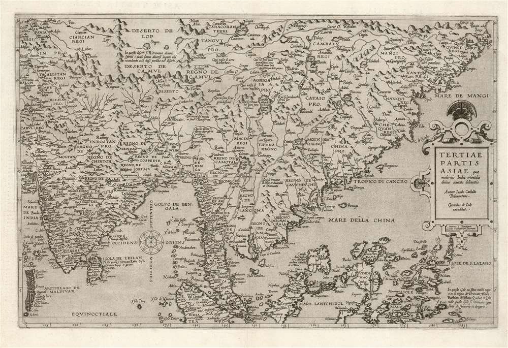
Tertiae Partis Asiae quae modernis India orientalis dicitur acurata delineatio Autore Iacobo Castaldo Pedemontano. Gerardus de Iode excudebat.
1578 (undated) 13 x 19.75 in (33.02 x 50.165 cm) 1 : 18000000
1578 (undated) 13 x 19.75 in (33.02 x 50.165 cm) 1 : 18000000
Description
This is a flawless example of the rare 1578 first edition of Gerard De Jode's map of India, the East Indies, and the Philippines. It is broad in scope, including all of India, most of China, the Philippine Islands, and the Malay Peninsula. Singapore appears under the name 'Cingatola.'
Sources
De Jode adheres closely to his model, Gastaldi's extremely rare 1561 four-sheet Il Dísegno Della Terza Parte Dell' Asía. Gastaldi's mapping of China, informed by Portuguese missionary reports, was not materially improved until the 17th century Sino-Jesuit surveys. His mapping of South Asia was standard convention until the revelations of Jan van Linschoten's 1596 Itinerario. De Jode preserves Gastaldi's comments in the original Italian, such as a reference to a 'Salt lake in which beautiful pearls can be found' and that in northwestern China, 'Here oxen are as large as elephants, producing the finest wool more than sheep.' In the Lop Desert of central Asia ( Xinjiang Uyghur Autonomous Region) it is noted that 'spirits give various deceptions so that wayfarers get lost in the desert.' The mapping of the Philippines and East Indies taps the travels of Magellan and Álvaro de Saavedra. An exploding volcano is pictured, marked 'Vulcan' based upon Ruy López de Villalobos' reports. A note accompanying the islands avers that in these islands are many kingdoms, namely Ternate, Titore and Bachian, Messana, Zubut and Zolo; in which islands can be found all sorts of spices and medicines.A Scarce Imprint from the Second Modern Atlas
Gerard De Jode was a successful publisher well established in Antwerp by the 1560s, so much so that Abraham Ortelius' first maps were printed on De Jode's presses. In spite of this, the 1570 advent of Ortelius' Theatrum Orbis Terrarum represented a challenge that De Jode does not seem to have been equal to. Gerard De Jode's atlas, Speculum Orbis Terrarum, did not appear until Ortelius's work was well established in the market. And while the execution of the De Jode maps was generally superior Ortelius', commercially it proved no match. Ortelius' diligent search for contemporary sources often outstripped De Jode's, and the well-connected Ortelius was able to stifle De Jode's output by successfully defending his privilege. Much of the stock of De Jode's 1578 edition was purchased by Ortelius and destroyed, to actively remove it from the market. Ortelius' atlas would run to approximately forty editions, while the elder De Jode was only able to produce one edition in his lifetime. His son Cornelis printed a sole updated edition of the work in 1593 which was nonetheless ineffective in breaking Ortelius' hammerlock on the market. As a result of Ortelius' success at the expense of the De Jodes, maps of the Speculum are as rare as they are important.Publication History and Census
This map was engraved by Johannes and Lucas Doetecum for inclusion in the 1578 first edition of Gerard De Jode's Speculum Orbis Terrarum. Gerard's son Cornelis produced a second edition in 1593, unchanged but clearly distinguishable by the typography on the verso. 1578 examples are paginated in Roman numerals, whilst the 1593 used Arabic numerals. We see only two separate examples of the 1578 edition appearing in institutional collections: the Bayerische Staatsbibliotek and the Sachsische Landesbibliothek (seven examples of the 1593 are cataloged in OCLC. Six copies of the Speculum are so listed.CartographerS
Gerard De Jode (1516/17 - February 5, 1591) was a Dutch publisher, engraver and cartographer active in Antwerp in the mid-to-late 16th century. De Jode was born in Nijmegen. Following a period as an apprentice and journeyman, (about which nothing comes down to us), he was admitted as a free master to Antwerp's artists' Guild of Saint Luke in 1547. He received the right to publish in that city in 1551. Henceforth he worked as a publisher and printseller in that city - although records also refer to him as a bookseller, art seller, map painter, engraver, and plate printer. He became one of Antwerp's most successful and prolific printers: he built up a large and varied stock of more than 1,200 prints and maps, and in addition to his own children maintained a shop and was taking on apprentices as early as 1549. De Jode's shop was home to many of Antwerp's best engravers, including the famous Van Doetecum brothers.
His publication in 1579 of the Thesaurus sacrarumhistoriarum veteris testamenti set the standard for over a century of Biblical illustration. His cartographic work began with the printing of other mapmakers' work (for example Gastaldi's map of the world in 1555, Jacob van Deventer's map of Brabant in 1558, and Ortelius' eight sheet map of the world in 1564.) He is best known for his 1578 atlas Speculum Orbis Terrarum. Despite the excellence of this work, it performed poorly due to the overwhelming competition posed by Abraham Ortelius' Theatrum Orbis Terrarum, which had already been eight years in publication. Between the Theatrum's popularity (and Ortelius' superior political connections, employed successfully in a vigorous defense of his license and monopoly on the work) De Jode's atlas was never a strong seller. Gerard printed only one edition of the work, compared to something on the order of 40 for the Ortelius atlas. Gerard de Jode planned an enlarged edition, but died before it could be finished. His son Cornelis de Jode completed the labor, publishing the Speculum Orbis Terrae in 1593. This edition, too, of the Speculum failed to compete with Ortelius' powerhouse. On top of that, much of the De Jodes' stock was actively purchased and destroyed by Ortelius and his executors in order to remove it from the market. Thus, oneresult of De Jode's ill-starred competition with Ortelius is that while most of Ortelius' maps are relatively ubiquitous on the market, all of De Jode's maps are rare, and sought after by the discerning collector. More by this mapmaker...
Giacomo Gastaldi (c. 1500 - October, 1566) was an Italian astronomer, cartographer, and engineer active in the second half of the 16th century. Gastaldi (sometimes referred to as Jacopo or Iacobo) began his career as an engineer, serving the Venetian Republic in that capacity until the fourth decade of the sixteenth century. During this time he traveled extensively, building a large library relating to voyages and exploration. From about 1544 he turned his attention to mapmaking, working extensively with Gextantiovanni Battista Ramusio, Nicolo Bascarini, and Giovanbattista Pedrezano, as well as taking private commissions for, among others, Venice's Council of Ten. He is credited with the fresco maps of Asia and Africa still extant in the map room of the Doge's Palace. Gastaldi was also one of the first cartographers to embrace copper plate over woodblock engraving, marking an important development in the history of cartography. His 1548 edition of Ptolemy's Geographia was the first to be printed in a vernacular; it was the first to be printed in copperplate. As with his Swiss/German contemporary Münster, Gastaldi's work contained many maps depicting newly discovered regions for the first time, including the first map to focus on the East Coast of North America, and the first modern map of the Indian Peninsula. His works provided the source for the vast majority of the Venetian and Roman map publishers of the 1560s and 70s, and would continue to provide an outsize influence on the early maps of Ortelius, De Jode, and Mercator. Learn More...
Johannes van Doetecum I (1528/32 - 1605, also spelled Duetecom, Duetecum, van Doetechum) was the patriarch of a Durch family of etchers and engravers, originally from Deventer. With his brother Lucas (died c. 1589), Johannes moved to Antwerp where they would work for a variety of publishers, inclufing Hieronymus Cock and Gerard de Jode. Their oeuvre included etched landscapes and ornamental work, but they are perhaps best known for the maps they produced not only for De Jode but also for Lucas Waghenaer, Petrus Plancius, and Linschoten. Learn More...
Source
De Jode, Gerard, Speculum Orbis Terrarum, (Antwerp: De Jode) 1578.
Gerard De Jode (1516/17 - 1591) first issued his spectacular atlas, the Speculum Orbis Terrae, in Antwerp in 1578. The atlas was intended to compete with Abraham Ortelius' Theatrum Orbis Terrarum, and as such, was a lavish production, beautifully engraved and compiled from the best cartography of the period. De Jode drew from such illustrious sources as G. Gastaldi, Pirro Ligorio, Alvaro Seco, Lieven Algoet, Heinrich Zell, Wolfgang Lazius, Augustin Hirsvogel, Sebastian Rotenhan, Aegidius Tschudi, Bartholomaeus Scultetus, and Caspar Vopel. Like due to his lack of political connects and general business acumen, De Jode's Speculum never attained the widespread popularity of Ortelius' Theatrum. When Gerard died in 1591, the firm was taken over by his son, Cornelis de Jode (1568 - 1600) and, his wife, Paschina. C. De Jode partnered with Arnold Coninx to publish a new edition of the Speculum Orbis Terrae in 1593. Cornelius died young at 32, and the De Jode stock was sold to Johannes Baptista Vrients (1552 - 1612). Vrients had earlier acquired Ortelius's map plates and was actively republishing them. He did not similarly republish the Speculum Orbis Terrae; rather, his purchase of the De Jode plates was intended to keep them off the market. Most were destroyed at his hands, resulting in them never being reprinted and being exceptionally scarce today.
Condition
Fine. A superb, unmarred example.
References
OCLC 159851987. Suarez, Thomas, Early mapping of Southeast Asia, (Hong Kong: Periplus).