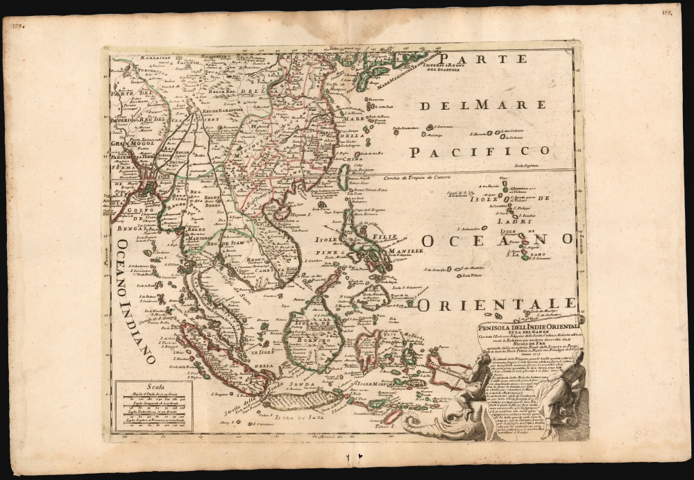
1717 Rare Petrini Map of Southeast Asia and the East Indies
EastIndies-petrini-1717
Title
1717 (dated) 16.5 x 20.25 in (41.91 x 51.435 cm) 1 : 14400000
Description
A Closer Look
The map presents the area of southeastern Asia spanning from the Gulf of Bengal in the west to just beyond the Mariana Islands (Isole de Ladri). It reaches from the southern coasts of Japan in the north to the island of Timor in the south, thus encompassing Indonesia, the Philippines, New Guinea, Southern China (with Hainan and Formosa), the kingdom of Siam, Cochinchina, and Cambodia. In the lower right, an attractive cartouche contains the title, imprint, and descriptive text. The image presents a scroll - containing the text - supported between two figures astride an elephant.Petrini's Source
Predominantly, Petrini draws his content from De Fer's 1698 wall map of Asia. Amongst other details, for example, the text in Borneo explaining that diamonds can be found in its two rivers also appears on De Fer's wall map. Similarly, he also draws from De Fer regarding Barantola (Tibet), which is described as the abode of the 'Grand Lama, head of all the lamas, that is, of the Western Tatar priests.' For the title, Petrini drew on another Italian mapmaker, Cantelli da Vignola: although Petrini's work does not resemble Cantelli's 1683 Penisola Dell India di la dal Gange.Apocryphal Lake Chiamay
The mythical Lake of Chiamay appears at the western extreme of the map, roughly in today's Assam, India. Early cartographers postulated that such a lake must exist to source the four important Southeast Asian river systems: the Irrawaddy, the Dharla, the Chao Phraya, and the Brahmaputra. This lake began to appear in maps of Asia as early as the 16th century and persisted well into the mid-18th century. Its origins are unknown but may originate in a lost 16th-century geography prepared by the Portuguese scholar Jao de Barros. It was also heavily discussed in the journals of Sven Hedin, who believed it to be associated with the Indian legend that a sacred lake, Mansarovar, linked several of the holy subcontinent river systems. There are even records that the King of Siam led an invasionary force to take control of the lake in the 16th century. Nonetheless, the theory of Lake Chiamay was ultimately disproved, and it disappeared from maps entirely by the 1760s.Publication History and Census
Petrini engraved this map for inclusion in his Atlante Partenopeo in 1717. A single known example is cataloged in the Eran Lau collection of the National Library of Israel. No record on the market.CartographerS
Paolo Petrini (c. 1670 - 1722) was an Italian bookseller, engraver, and publisher active in Naples at the turn of the 18th century. He was not primarily a cartographer, but rather a publisher and engraver, and as such his maps are cartographically derivative of Nicolas (1600 - 1667), Guillaume Sanson (1633 - 1703), Nicolas De Fer (1646 - 1720), and Giacomo Cantelli da Vignola (1643 - 1695). He issued allegorical prints (many made after Painter Luca Giordano), a handful of wall maps, and his supremely rare 1700 atlas, Atlante Partenopeo. At some point in his career in or after 1700, Petrini received an Privilege, a kind of early copyright, likely from Philip V of Spain, who was the King of Naples. After his death in 1722, the firm was taken over by his son, Michele Angelo Petrini, who reissued some of his works. Little else is known of Petrini, whose life is as obscure as his works are rare. More by this mapmaker...
Nicholas de Fer (1646 - October 25, 1720) was a French cartographer and publisher, the son of cartographer Antoine de Fer. He apprenticed with the Paris engraver Louis Spirinx, producing his first map, of the Canal du Midi, at 23. When his father died in June of 1673 he took over the family engraving business and established himself on Quai de L'Horloge, Paris, as an engraver, cartographer, and map publisher. De Fer was a prolific cartographer with over 600 maps and atlases to his credit. De Fer's work, though replete with geographical errors, earned a large following because of its considerable decorative appeal. In the late 17th century, De Fer's fame culminated in his appointment as Geographe de le Dauphin, a position that offered him unprecedented access to the most up to date cartographic information. This was a partner position to another simultaneously held by the more scientific geographer Guillaume De L'Isle, Premier Geograph de Roi. Despite very different cartographic approaches, De L'Isle and De Fer seem to have stepped carefully around one another and were rarely publicly at odds. Upon his death of old age in 1720, Nicolas was succeeded by two of his sons-in-law, who also happened to be brothers, Guillaume Danet (who had married his daughter Marguerite-Geneviève De Fer), and Jacques-François Bénard (Besnard) Danet (husband of Marie-Anne De Fer), and their heirs, who continued to publish under the De Fer imprint until about 1760. It is of note that part of the De Fer legacy also passed to the engraver Remi Rircher, who married De Fer's third daughter, but Richer had little interest in the business and sold his share to the Danet brothers in 1721. Learn More...

