This item has been sold, but you can get on the Waitlist to be notified if another example becomes available, or purchase a digital scan.
1863 Colton Map of Eastern North Carolina w/interesting provenance
EaternNorthCarolina-colton-1863$3,000.00

Title
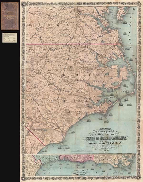
Colton's New Topographical Map of the Eastern Portion of the State of North Carolina with Part of Virginia and South Carolina from the latest and best authorities.
1863 (dated) 41.5 x 28 in (105.41 x 71.12 cm) 1 : 506880
1863 (dated) 41.5 x 28 in (105.41 x 71.12 cm) 1 : 506880
Description
This is an impressive large scale 1863 J. H. Colton map of the eastern part of North Carolina during the American Civil War. It is from the library of Union Brigadier General Edward Augustus Wild, the abolitionist leader of the United Stated Colored Troops. This stunning map covers from Virginia and the entrance to the Chesapeake Bay to South Carolina, focusing on the eastern part of North Carolina and the Outer Banks. The Union blockade of the North Carolina coast is illustrated by the presence of 18 ships. The topography throughout is beautifully detailed with rail lines, towns, swamps, political boundaries, and more identified. Along the bottom of the sheet, a secondary map, 'Plan of the Sea Coast from Virginia to Florida offers an overall picture of the Atlantic seaboard during the war.
This map comes with a fascinating provenance. It was originally owned by Union Brigadier General Edward Augustus Wild during the American Civil War. Wild was a staunch abolitionist and organized and commanded the United Stated Colored Troops, an infantry regiment comprised from freedmen recruits. 'Wild's African Brigade,' as it came to be known, was headquartered in Norfolk and comprised the 55th Massachusetts Infantry, and the 2nd and 3rd North Carolina Colored Volunteers (which later became renumbered as the 36th and 37th U.S. Colored Troops respectively). Wild's men served primarily in North Carolina – as covered by our map – and took part in meaningful action against Confederate guerillas, where they destroyed rebel camps and freed hundreds, if not thousands, of slaves. Wild's signature appears on the inside of the binder. From Wild, the map passed into the hands of the Boston based 'Library of the Commandery of the State of Massachusetts Military Order of the Loyal Legion of the United States,' whose pastedown, also bearing a reference to Wild, is included. It was next acquired by Harvard University, who sold it in their duplicate sale on March 5, 1947.
The identifier 'No. 11' appears in the upper left corner, suggesting that this map may have been part of a series intended to illustrate the events of the Civil War, and indeed we have identified a more common but similar map Colton's Topographical Map of the Seat of War in Virginia, Maryland … as part of the same series.
There appear to be several issues of this map. Our example, printed by Lang and Cooper, bears a copyright of 1860 and an issue date, under the cartouche of 1863. Another version, printed by Lang and Laing, a predecessor of Lang and Cooper, appears with an 1861 copyright date, and an 1862 date under the cartouche. Rumsey suggests that this map first issued in 1861, despite the 1860 copyright, and was last issued in 1864 – although we have found no examples of that edition. Today this map is exceedingly rare outside of institutional collections.
CartographerS
Joseph Hutchins Colton (July 5, 1800 - July 29, 1893), often publishing as J. H. Colton, was an important American map and atlas publisher active from 1833 to 1897. Colton's firm arose from humble beginnings when he moved to New York in 1831 and befriended the established engraver, Samuel Stiles. He worked under Stiles as the 'Co.' in Stiles and Co. from 1833 to 1836. Colton quickly recognized an emerging market in railroad maps and immigrant guides. Not a cartographer or engraver himself, Colton's initial business practice mostly involved purchasing the copyrights of other cartographers, most notably David H. Burr, and reissuing them with updated engraving and border work. His first maps, produced in 1833, were based on earlier Burr maps and depicted New York State and New York City. Between 1833 and 1855, Colton proceeded to publish a large corpus of guidebooks and railroad maps, which proved popular. In the early 1850s, Colton brought his two sons, George Woolworth Colton (1827 - 1901) and Charles B. Colton (1832 - 1916), into the map business. G. W. Colton, trained as a cartographer and engraver, was particularly inspired by the idea of creating a large and detailed world atlas to compete with established European firms for the U.S. market. In 1855, G.W. Colton issued volume one of the impressive two-volume Colton's Atlas of the World. Volume two followed a year later. Possibly because of the expense of purchasing a two-volume atlas set, the sales of the Atlas of the World did not meet Colton's expectations, and so, in 1856, the firm also issued the atlas as a single volume. The maps contained in this superb work were all original engravings, and most bear an 1855 copyright. All of the maps were surrounded by an attractive spiral motif border that would become a hallmark of Colton's atlas maps well into the 1880s. In 1857, the slightly smaller Colton's General Atlas replaced the Atlas of the World. Most early editions of the General Atlas published from 1857 to 1859 do not have the trademark Colton spiral border, which was removed to allow the maps to fit into a smaller format volume. Their customers must have missed the border because it was reinstated in 1860 and remained in all subsequent publications of the atlas. There were also darker times ahead; in 1858, Colton was commissioned at a sum of 25,000 USD by the government of Bolivia to produce and deliver 10,000 copies of a large format map of that country. Although Colton completed the contract in good faith, delivering the maps at his own expense, he was never paid by Bolivia, which was at the time in the midst of a series of national revolutions. Colton would spend the remainder of his days fighting with the Bolivian and Peruvian governments over this payment, and in the end, after a congressional intervention, he received as much as 100,000 USD in compensation. Nonetheless, at the time, it was a disastrous blow. J. H. Colton and Company is listed as one of New York's failed companies in the postal record of 1859. This led Colton into the arms of Alvin Jewett Johnson and Ross C. Browning. The 1859 edition of Colton's General Atlas lists Johnson and Browning as the 'Successor's to J. H. Colton' suggesting an outright buyout, but given that both companies continued to publish separately, the reality is likely more complex. Whatever the case may have been, this arrangement gave Johnson and Browning access to many of Colton's map plates and gave birth to Johnson's New Illustrated (Steel Plate) Family Atlas. The Johnson's Atlas was published parallel to Colton's atlases well into the 1880s. The Colton firm itself subsequently published several other atlases including an Atlas of America, the Illustrated Cabinet Atlas, the Octavo Atlas of the Union, and Colton's Quarto Atlas of the World. They also published a large corpus of wall maps, pocket maps, and guides. The last known publications of the Colton firm date to 1897 and include a map and a view, both issued in association with the Merchant's Association of New York. Alice M. Colton married August R. Ohman (May 3, 1859 - April 22, 1934) on January 5, 1897. In 1898, Ohman joined the Colton firm, which continued to publish as Colton, Ohman & Co. until 1901. More by this mapmaker...
Lang and Cooper (fl. August 16, 1862 - May 2, 1864) were a New York City based engravers and printers active in the middle part of the 19th century. The firm was founded by William Lang and Henry Pooley Cooper. The firm came into being following the dissolution of Lang and Laing where in Cooper took the place of Joseph Laing. In May 1864, Cooper bought out Lang's shares and subsequently published under his own imprint, H. P. Cooper. They specialized in transferring copper and steel plates to lithographic stone for more economical printing. Among others, the firm worked with J.H. Colton and J. Disturnell. Learn More...
Condition
Very good. Backed on archival tissue and removed from, but accompanied by, original binder and old library stamp. Minor fill repair to upper right margin, just to the right of the letters 'ATLA' in 'ATLANTIC' impacting printed area by about 1mm.
References
LC Civil War maps (2nd ed.) 304.85. Stephenson 304.85. Rumsey 3044.000.