1725 Allard map of England and Wales
England-allard-1697$950.00
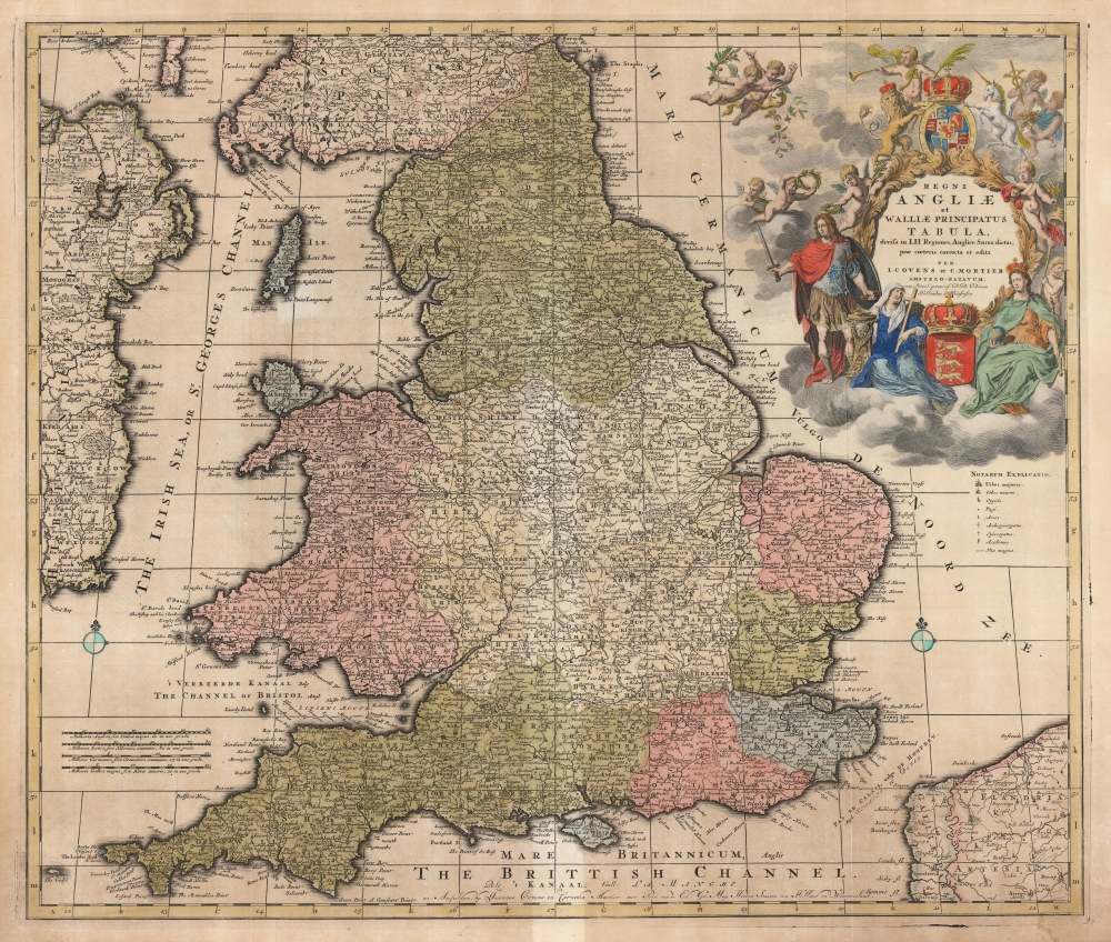

Title
Regni Angliae et Walliae Principatus Tabula, divisa in LII Regiones, Anglice Shire dictas, prae coeteris correcta et edita per I. Covens et C. Mortier Amstelo-Batavum.
1697 (undated) 19.75 x 23.25 in (50.165 x 59.055 cm) 1 : 1300000
1697 (undated) 19.75 x 23.25 in (50.165 x 59.055 cm) 1 : 1300000
Description
This is Carel Allard's 1697 map of England and Wales, in its 1725 Covens and Mortier edition. Between the superb engraving of the map and its ornate cartouches, it is one of the most richly decorative maps of England produced in that era.
The cartouche is surmounted by William's royal arms as King of England, the arms are accompanied by England's lion and unicorn. A riot of putti flutter about, allowing Tideman to include a broad array of allegorical references. Behind the seated Mary/Britannia, a putto takes the role of the Dutch Maiden (bearing a phrygian cap on a liberty pole, the Dutch Maiden had become a symbol of the United Provinces. In this case, this 'Dutch putto' represents the power behind the throne. Another of these pudgy cherubim clutches a bundle of thistles, a reference to Scotland. In the background a pair of putti congratulate one another: one brandishing Hermes' cadeuceus, the other cradling a cornucopia - expressing the idea that the change of the English throne would be good for business. On the left, a quintet of putti on the wing scatter flowers at William, and hold laurels of victory over his head. Atop all, a putto puffing on a trumpet and clutching a palm branch takes the role of fame, proclaiming the deeds of William and Mary to the world.
The Reach of the Map
Centered on England and Wales, the map includes the east coast of Ireland, the southern border region of Scotland, and the coast of France and Flanders across the English Channel.A Superb Engraving
Allard's fine engraving and generous plate size allows for granular detail and a multitude of place names. The relative size of towns is indicated with symbols listed in a key; there are also symbols for colleges, bishoprics, archbishoprics, and high roads. Hadrian's wall, spanning from Newcastle to Carlisle, is marked at the southern extreme, here named 'The Pictes Wall.' It is the map's elaborate cartouche, however, which most commands the eye. It was engraved by Gilliam van der Gouwen, but composed by allegorist Philip Tideman. It is a celebration of the Glorious Revolution of 1688-89, which resulted in the ascension of William III, Prince of Orange, and his wife Mary II to the British throne. William is presented at left in a martial pose; to the left, a seated and crowned figure - often identified as Britannia - may in fact depict Mary, bearing the orb and scepter. Much of William's claim to the throne, after all, was tied to his marriage to an undisputed heir. Another Marian figure - veiled, bearing a cross - is on the ground at William's left hand, next to a holy water basin, perhaps an allusion to the subordination of the Catholic Church by the staunchly Protestant William.The cartouche is surmounted by William's royal arms as King of England, the arms are accompanied by England's lion and unicorn. A riot of putti flutter about, allowing Tideman to include a broad array of allegorical references. Behind the seated Mary/Britannia, a putto takes the role of the Dutch Maiden (bearing a phrygian cap on a liberty pole, the Dutch Maiden had become a symbol of the United Provinces. In this case, this 'Dutch putto' represents the power behind the throne. Another of these pudgy cherubim clutches a bundle of thistles, a reference to Scotland. In the background a pair of putti congratulate one another: one brandishing Hermes' cadeuceus, the other cradling a cornucopia - expressing the idea that the change of the English throne would be good for business. On the left, a quintet of putti on the wing scatter flowers at William, and hold laurels of victory over his head. Atop all, a putto puffing on a trumpet and clutching a palm branch takes the role of fame, proclaiming the deeds of William and Mary to the world.
Publication History and Census
This map was engraved for Carel Allard around 1697 for inclusion in his atlases. The plate was eventually acquired by Amsterdam publishers Covens and Mortier, who replaced Allard's imprints throughout with their own but made no further changes to the work; they kept it in print as late as the 1740s. The map is well represented in institutional collections and appears on the market from time to time.CartographerS
Carel Allard (1648 - 1709) was a Dutch art dealer, cartographer and engraver. In the 17th century, the Allard family published various maps in Amsterdam. Carel was the son of mapmaker and engraver Hugo Allard. He appears to have been somewhat prolific and successful than his father: he produced in his lifetime a 1697 Atlas Minor, the c. 1705 Atlas Major and several other works with engraved plates, as well as continuing to publish from his father's stock. He passed along his copperplates to his son Abraham (1676-1725) prior to going bankrupt in 1706. More by this mapmaker...
Covens and Mortier (1721 - c. 1862) was an Amsterdam publishing firm, the successor to the extensive publishing empire built by Pierre Mortier (1661 - 1711). Covens and Mortier maps are often criticized as derivative - but this is not fully the case. Pierre Mortier lived in Paris from 1681 to 1685. There he established close relationships the the greatest French cartographers of the era, including De L'Isle and D'Anville. His business model was based upon leveraging Dutch printing technology and sophistication to co-publish state of the art French cartography. Upon Mortier's death in 1711 his firm was taken over by his son, Cornelius Mortier (1699 - 1783). Cornelius married the sister of Johannes Covens (1697 - 1774) in 1721 and, partnering with his brother in law, established the Covens and Mortier firm. Under the Covens and Mortier imprint, Cornelius and Johannes continued in Pierre's model of publishing the most up-to-date French works with permission. They quickly became one of the largest and most prolific Dutch publishing concerns of the 18th century. The firm and its successors published thousands of maps over a 120 year period from 1721 to the mid-1800s. During their long lifespan the Covens and Mortier firm published as Covens and Mortier (1721 - 1778), J. Covens and Son (1778 - 94) and Mortier, Covens and Son (1794 - c. 1862). Learn More...
Philip Tideman (1657-1705) was a Hamburg-born painter, active in Amsterdam during the Dutch Golden Age. There, he became associated with painter Gerard de Lairess, in whose work Tideman's compositions sometimes appear. Tideman began to make a name for himself with his allegorical paintings with which he decorated the homes of many of the important men; these have been captured in de Lairess' paintings of those spaces. Tideman also partnered with engraver Gilliam van der Gouwen 1650-1720), who committed Tideman's images to print. Their partnership extended to maps, for example in the allegorical cartouches featured on many of the maps printed by Carel Allard. Learn More...
Gilliam van der Gouwen, (c. 1657 - March 15, 1716) was a Flemish engraver active in the Netherlands during the Dutch Golden Age. He is known for his reproductive engravings and various title pages, maps and illustrations produced in Amsterdam. He was born in Antwerp, and was trained there as an engraver by Pieter van Lisebetten. In June 1680 was in Amsterdam taking drawing classes with German painter Pieter Rodingh. He also is understood to have studied with painter Gerard de Lairesse, and collaborated with him on a number of publications. It is likely that this association put him in contact with artist Philip Tideman (1657-1705) with whom he would collaborate extensively. Learn More...
Condition
Very good. Lightly toned with some marginal staining; pale along centerfold. Early hand color, possibly original.
References
OCLC 611361126.